
 Dundee Precious Metals (T.DPM) is a Canadian-based international mining company engaged in the acquisition, exploration, development, mining and processing of precious metal properties. Our current operations are in Namibia and Bulgaria, with exploration in Armenia, Bulgaria and Serbia.
Click for TMX Money Dundee Precious Metals (T.DPM) stock price
For more information please go to the Dundee Precious Metals website.
Updates
click the headline
Press Releases
click the headline
The Stream
Everything about Dundee Precious Metals
Cartier Silver Corp. Announces Second-Phase Diamond Drilling Program at the High-Grade Silver (Lead and Zinc) Chorrillos Project in Southern Bolivia. Dewatering and Rehabilitation of Underground Adits at the Gonalbert Zone to Commence
Cartier Silver Corporation (CSE: CFE) (“Cartier Silver” or the “Company”) is pleased to announce the second-phase diamond drilling campaign comprising 5,000 metres across 12 drillholes at the Company’s Chorrillos high-grade Silver-Lead-Zinc Project (the “Chorrillos Project”), together with the commencement of a structured underground dewatering and rehabilitation program.
Tom Larsen, CEO of Cartier Silver, commented: “We are on track to resume diamond drilling in June 2026. The program is designed to identify new high-grade mineralized structures and expand our understanding of the existing veins and confirm the newly discovered high-grade silver, lead and zinc structures identified during the first drilling phase. Additionally, we are looking forward to drilling, for first time, highly prospective target areas such as Quimbalete – Hoyada and Felicidad.”
Mr. Larsen continued: “The dewatering and rehabilitation program on the previous underground mining operations, outlined by our geological and engineering group, represents a critical step in advancing the project, as it will enable the Company to quickly procure vital data that can be used for future economic modelling.”
The Second-Phase Drilling Program
The 5,000 m 12-hole second-phase diamond drilling program at the Chorrillos Property is scheduled to commence in June with the following key objectives:
- To assess the continuity of known mineralization: primarily along the southern projection of the Central Vein (at Mina Central), where underground sampling at levels -40 and -60 identified areas with high grades of silver and lead, and significant zinc content.
- To evaluate possible new vein structures: Primarily from two veins first intersected by drill hole DGL-01 during the Company’s 2023 drilling campaign (refer to the Company’s press release dated September 7, 2023).
- To extend the continuity of previously defined mineralization in both surface and underground workings beneath and within the pyroclastic cover in the volcanic area approximately 500m north of the Central vein target area.
- To test the continuity of the Quimbalete vein below the -30 level, and explore possible parallel structures associated with the main vein at the La Hoyada-Quimbalete zone.
Details of the drilling campaign are presented in Table 1, including location coordinates, depths, and specific targets for each drillhole.
Table 1: Scheduled Second-Phase Drilling Program
| Drillhole ID | Easting | Northing | Elevation (m) | Target Depth (m) | Area | Objective |
| DGL-04 | 219004 | 7637366 | 3667 | 500 | Ordovician Sedimentary Central South | Southern projection of Central vein system. Exploration for new mineralized structures |
| DGL-05 | 219004 | 7637366 | 3667 | 450 | Ordovician Sedimentary Central South | Southern projection of Central vein system. Exploration for new mineralized structures |
| DGL-06 | 218841 | 7638058 | 3597 | 200 | Tertiary Volcanic – Hoyada | Projection to depth of Quimbalete vein |
| DGL-07 | 218923 | 7637992 | 3594 | 150 | Tertiary Volcanic – Hoyada | Projection to depth of Quimbalete vein |
| DGL-08 | 218712 | 7638087 | 3561 | 150 | Tertiary Volcanic – Hoyada | Projection to depth of Quimbalete vein |
| DGL-09 | 218738 | 7638238 | 3584 | 150 | Tertiary Volcanic -Hoyada | Exploration of a geophysical and geochemical anomalies |
| DGL-10 | 218877 | 7637496 | 3654 | 700 | Ordovician Sedimentary Central North | Intersect three vein-type structures of similar trend of Central Vein |
| DGL-11 | 219006 | 7637265 | 3660 | 500 | Ordovician Sedimentary Central South | Southern projection of Central vein system. Exploration for new mineralized structures |
| DGL-12 | 218877 | 7637496 | 3654 | 600 | Ordovician Sedimentary Central North | Intersect three vein-type structures of similar trend of Central Vein |
| DGL-13 | 218837 | 7637711 | 3615 | 600 | Ordovician Sedimentary – Volcanic Central North | Intersect three vein-type structures of similar trend of Central Vein |
| DFL-01 | 216648 | 7644231 | 3557 | 500 | Tertiary Epiclastics-Volcanic Felicidad | Intercept the mineralized trend system with the projection of the Felicidad vein |
| DFL-02 | 216648 | 7644231 | 3557 | 500 | Tertiary Epiclastics-Volcanic Felicidad | Intercept the mineralized trend system with the projection of the Felicidad vein |
| TOTAL | 5000 |

Figure 1: Geological Plan Map of Gonalbert Property Showing Locations of Completed and Proposed Diamond Drill Holes.
To view an enhanced version of this graphic, please visit:
https://images.newsfilecorp.com/files/11987/298836_e8b6953004f62a18_002full.jpg

Figure 2: Geological Plan Map of Gonalbert Property Showing Locations of Executed and Proposed Diamond Drill Holes.
To view an enhanced version of this graphic, please visit:
https://images.newsfilecorp.com/files/11987/298836_e8b6953004f62a18_003full.jpg
Dewatering and Rehabilitation of Underground Workings in the Central Mine – Gonalbert zone
The Company is proceeding with the dewatering of former mine underground workings (-140 -180 Levels), including an existing 180 m shaft (Central Mine), together with rehabilitation activities at the Chorrillos Project.
Dewatering of the Central Mine in the Gonalbert Zone with access to the underground workings from the Central Mine is expected to be completed by the end of the third quarter 2026. Access to the underground workings will enable the Company to evaluate and formulate further development and exploration programs on an expedited basis.
Preliminary Mineral Characterization on samples from Gonalbert Zone
Wardell Armstrong International was commissioned by Cartier Silver to complete characterisation testwork on two samples originating from the Gonalbert Pb-Zn-Ag zone. Head assay analysis on the oxide sample indicated the sample contained 0.59% Pb and 14.6ppm Ag with the sulphide sample containing 39.7% Pb, 7.4% Zn and 1,112ppm Ag.
The sulphide sample mineralogy confirmed that virtually 100% of the lead was in the form of galena and all the zinc was in the form of sphalerite. Both galena and sphalerite were seen to have high liberation, with 96% of the galena and 90% of the sphalerite present as free/liberated particles.
The potential processing flowsheet for the sulphide material could involve a primary grind of 150-250µm followed by standard differential lead-zinc froth flotation. Due to the liberation observed, it is unlikely that any regrinding of rougher concentrates will be required which would further reduce capital costs and simplify the circuit. The liberation statistics for the galena and sphalerite would likely result in good metal recoveries and concentrate grades with low loss of zinc to the lead concentrate.
Positive results from preliminary mineral characterization confirm the technical viability of extracting target metals or minerals from representative samples in the Chorrillos project. Such data provides the necessary foundation to advance the project.
The Chorrillos Project
The Chorrillos Project is situated within a polymetallic belt in the Eastern Cordillera, Southern Bolivia, which is characterized by complex tectonic and magmatic evolution favorable for the development of mineralized systems rich in silver, lead and zinc. It comprises two main areas: Gonalbert and Felicidad (Figure 2). The mineralization is hosted in Ordovician rocks and in Tertiary volcanic sequences (lithic tuffs) and epiclastic intruded by dacitic dikes and controlled by two major structural systems-oriented NW-SE and WNW-ESE, which significantly influence the direction and/or continuity of the mineralized structures.
Qualified Person
Dr. Osvaldo Arce, P.Geo. General Manager of Cartier Silver’s Bolivian subsidiary, Cartier Silver Bolivia S.R.L, and a Qualified Person (“QP”) as defined by National Instrument (“NI”) 43-101 has reviewed and approved the technical content of this news release. Dr. Arce who has more than 35 years of mineral exploration and extensive mining expertise across several countries in North and South America manages the overall technical program and supervises all field work conducted at Chorrillos project.
Cartier Silver utilized both ALS and AHK for drill core analyses, both of whom are major international accredited laboratories. Drill samples sent to ALS were prepared in both ALS Bolivia Ltda’s preparation facility in Oruro, Bolivia and the preparation facility operated by AHK in Tupiza with pulps sent to the main ALS Global laboratory in Lima for analysis. Drill core samples sent to AHK Laboratories are also prepared by AHK in Tupiza with pulps sent to the AHK laboratory in Lima, Peru.
Silver (Ag), zinc (Zn) and lead (Pb) are analyzed by Inductively Coupled Plasma Atomic Emission Spectroscopy (ICP-AES) using a four-acid digestion; Sn is analyzed by X-Ray Fluorescence (XRF) and Au is analyzed by fire assay on 50g pulps with an Atomic Absorption Spectroscopy (AAS) finish. AAS measures absorbed light to quantify elements, while ICP, such as ICP-OES or ICP-MS, measure emitted light or ions to determine elements. XRF uses fluorescent X-rays to excite atoms and to emit X-rays that reveal the presence and concentration of tin. Sample size in ICP typically ranges from 100 mg (0.1 g) to 1 g, for AAS, is usually less than 100 mg (0.1 g) and for XRF is ideally below 75 µm.
Check samples between ALS and AHK are regularly done as a QA/QC check. AHK is following the same analytical protocols used as with ALS and with the same QA/QC protocols except for Sn for which a sodium peroxide fusion is used at AHK following by ICP. Check comparisons of Sn results from ALS and ALS indicate no statistically significant difference between results using the two different analytical techniques.
Cartier employs an industry standard QA/QC program with standards, blanks and duplicates inserted into each batch of samples analyzed at both laboratories with selected check samples sent to a separate accredited laboratory. Check results are regularly monitored.
About Cartier Silver Corporation
Cartier Silver is an exploration and development Company focused on discovering and developing its silver property assets, including the Chorrillos Project and claims staked by the Company’s subsidiary, all of which are located in the Potosi Department of southern Bolivia. The Company also holds significant iron ore resources at its Gagnon Holdings in the southern Labrador Trough region of east-central Quebec, and the Big Easy gold property in the Burin Peninsula epithermal gold belt in the Avalon Zone of eastern Newfoundland and Labrador.
For further information please visit Cartier Silver’s website at www.cartiersilvercorp.com
For further information please contact:
Thomas G. Larsen
Chief Executive Officer
(800) 360-8006
(416) 360-8006
Jorge Estepa
Vice-President
(800) 360-8006
(416) 360-8006
The CSE has not reviewed nor accepts responsibility for the adequacy or accuracy of this release.
Information in this news release may contain forward-looking information. Statements containing forward-looking information express, as at the date of this news release, the Company’s plans, estimates, forecasts, projections, expectations, or beliefs as to future events or results and are believed to be reasonable based on information currently available to the Company. There can be no assurance that forward-looking statements will prove to be accurate. Actual results and future events could differ materially from those anticipated in such statements. Readers should not place undue reliance on forward-looking information.
Source: Cartier Silver Corporation
NexGen Announces the Appointment of Ryan Podrasky as Chief Financial Officer
Ryan Podrasky is a CPA-designated finance executive with more than 25 years of leadership across global mining and oil and gas companies. He most recently served as Chief Financial Officer of Elk Valley Resources – formerly the coal business of Teck Resources and now majority-owned by Glencore – where he led the finance function for a $10B+ revenue business that is the largest steelmaking coal producer in Canada and the second-largest seaborne supplier globally. In that capacity he had oversight of approximately $5B in annual operating and capital expenditures across a complex, multi-site, fully integrated mine-to-port value chain employing 5,700+ people and led a comprehensive and strategic finance organization. Ryan has served for over five years as Board Director of Neptune Bulk Terminals (Canada) Ltd., where he chaired the Audit, Finance, and Insurance Committees.
Prior to being appointed full-time CFO, Ryan served as Acting CFO during the separation of Teck’s coal business into a standalone entity, where he helped lead one of Canada’s most complex large-scale corporate carve-outs. He worked closely with the corporate teams in Vancouver establishing the standalone capital structure, treasury framework, financial systems, and governance model for a multi-billion-dollar mining organization.
Before joining Teck, Ryan spent over a decade at Nexen Inc. in Calgary, progressing from Joint Venture Auditor through to Corporate Development, where he supported enterprise strategy, capital projects, and joint venture partnerships across large-scale oil sands and international operations. He also held a commercial leadership role at Talisman Energy, where he led a cross-functional team supporting planning, performance management, and strategic decision-making across North American operations.
Leigh Curyer, Founder & Chief Executive Officer, commented: “It’s with great pleasure that we announce Ryan has been appointed Chief Financial Officer of NexGen effective May 25, 2026. Ryan joins NexGen with significant experience on successful large-scale resource projects covering the financing, reporting, budgetary management and commercial functions during the construction and operating phases. I would like to take the opportunity to acknowledge and thank Ben for his commitment, dedication and positive influence in his role as Chief Financial Officer of NexGen for the past 3 years.
He has overseen the finance function with distinction and has been an absolute pleasure to work alongside in the senior executive team. His contribution to NexGen is and will always be highly regarded.
The Board and Executive wish Ben all the very best in his future as he takes some well-deserved time off to spend with his family and pursue personal interests.”
About NexGen
NexGen Energy is a Canadian company focused on delivering clean energy fuel for the future. The Company’s flagship Rook I Project is being optimally developed into the largest low cost producing uranium mine globally, incorporating the most elite standards in environmental and social governance. The Rook I Project is supported by a NI 43-101 compliant Feasibility Study which outlines the elite environmental performance and industry leading economics. NexGen is led by a team of experienced uranium and mining industry professionals with expertise across the entire mining life cycle, including exploration, financing, project engineering and construction, operations and closure. NexGen is leveraging its proven experience to deliver a Project that leads the entire mining industry socially, technically and environmentally. The Project and prospective portfolio in northern Saskatchewan will provide generational long-term economic, environmental, and social benefits for Saskatchewan, Canada, and the world.
NexGen is listed on the Toronto Stock Exchange, the New York Stock Exchange under the ticker symbol “NXE” and on the Australian Securities Exchange under the ticker symbol “NXG” providing access to global investors to participate in NexGen’s mission of solving three major global challenges in decarbonization, energy security and access to power. The Company is headquartered in Vancouver, British Columbia, with its primary operations office in Saskatoon, Saskatchewan.
Contact Information
Leigh Curyer
Chief Executive Officer
NexGen Energy Ltd.
+1 604 428 4112
lcuryer@nxe-energy.ca
www.nexgenenergy.ca
Travis McPherson
Chief Commercial Officer
NexGen Energy Ltd.
+1 604 428 4112
tmcpherson@nxe-energy.ca
www.nexgenenergy.ca
Monica Kras
Vice President, Corporate Development
NexGen Energy Ltd.
+44 7307 191933
mkras@nxe-energy.ca
www.nexgenenergy.ca
Forward-Looking Information
The information contained herein contains “forward-looking statements” within the meaning of applicable United States securities laws and regulations and “forward-looking information” within the meaning of applicable Canadian securities legislation. “Forward-looking information” includes, but is not limited to, statements with respect to mineral reserve and mineral resource estimates, the 2021 Arrow Deposit, Rook I Project and estimates of uranium production, grade and long-term average uranium prices, anticipated effects of completed drill results on the Rook I Project, planned work programs, completion of further site investigations and engineering work to support basic engineering of the project and expected outcomes. Generally, but not always, forward-looking information and statements can be identified by the use of words such as “plans”, “expects”, “is expected”, “budget”, “scheduled”, “estimates”, “forecasts”, “intends”, “anticipates”, or “believes” or the negative connotation thereof or variations of such words and phrases or state that certain actions, events or results “may”, “could”, “would”, “might” or “will be taken”, “occur” or “be achieved” or the negative connotation thereof. Statements relating to “mineral resources” are deemed to be forward-looking information, as they involve the implied assessment that, based on certain estimates and assumptions, the mineral resources described can be profitably produced in the future.
Forward-looking information and statements are based on the then current expectations, beliefs, assumptions, estimates and forecasts about NexGen’s business and the industry and markets in which it operates. Forward-looking information and statements are made based upon numerous assumptions, including among others, that the mineral reserve and resources estimates and the key assumptions and parameters on which such estimates are based are as set out in this news release and the technical report for the property, the results of planned exploration activities are as anticipated, the price and market supply of uranium, the cost of planned exploration activities, that financing will be available if and when needed and on reasonable terms, that third party contractors, equipment, supplies and governmental and other approvals required to conduct NexGen’s planned exploration activities will be available on reasonable terms and in a timely manner and that general business and economic conditions will not change in a materially adverse manner. Although the assumptions made by the Company in providing forward-looking information or making forward-looking statements are considered reasonable by management at the time, there can be no assurance that such assumptions will prove to be accurate in the future.
Forward-looking information and statements also involve known and unknown risks and uncertainties and other factors, which may cause actual results, performances and achievements of NexGen to differ materially from any projections of results, performances and achievements of NexGen expressed or implied by such forward-looking information or statements, including, among others, the existence of negative operating cash flow and dependence on third party financing, uncertainty of the availability of additional financing, the risk that pending assay results will not confirm previously announced preliminary results, conclusions of economic valuations, the risk that actual results of exploration activities will be different than anticipated, the cost of labour, equipment or materials will increase more than expected, that the future price of uranium will decline or otherwise not rise to an economic level, the appeal of alternate sources of energy to uranium-produced energy, that the Canadian dollar will strengthen against the U.S. dollar, that mineral resources and reserves are not as estimated, that actual costs or actual results of reclamation activities are greater than expected, that changes in project parameters and plans continue to be refined and may result in increased costs, of unexpected variations in mineral resources and reserves, grade or recovery rates or other risks generally associated with mining, unanticipated delays in obtaining governmental, regulatory or First Nations approvals, risks related to First Nations title and consultation, reliance upon key management and other personnel, deficiencies in the Company’s title to its properties, uninsurable risks, failure to manage conflicts of interest, failure to obtain or maintain required permits and licences, risks related to changes in laws, regulations, policy and public perception, as well as those factors or other risks as more fully described in NexGen’s Annual Information Form dated March 3, 2026 filed with the securities commissions of all of the provinces of Canada and in NexGen’s 40-F filed with the United States Securities and Exchange Commission, which are available on SEDAR+ at www.sedarplus.ca and Edgar at www.sec.gov.
Although the Company has attempted to identify important factors that could cause actual results to differ materially from those contained in the forward-looking information or statements or implied by forward-looking information or statements, there may be other factors that cause results not to be as anticipated, estimated or intended. Readers are cautioned not to place undue reliance on forward-looking information or statements due to the inherent uncertainty thereof.
There can be no assurance that forward-looking information and statements will prove to be accurate, as actual results and future events could differ materially from those anticipated, estimated or intended. Accordingly, readers should not place undue reliance on forward-looking statements or information. The Company undertakes no obligation to update or reissue forward-looking information as a result of new information or events except as required by applicable securities laws.
NexGen’s Final Batch of 2025 Assays Return Multiple High-Grade Intercepts. Confirming Both Expansion and Continuity of Primary High-Grade Subdomain and Confirmation of New High-Grade Subdomain at Depth
Results from RK-25-240 emphasize the potential extension of mineralization at depth where the system is open. Together with these results, the grades from RK-25-230 (Figure 4), RK-25-233, RK-25-236 have confirmed a strong core zone within the high-grade subdomain which remains open in most directions.
Within the overall mineralized footprint, a new secondary high-grade subdomain is now confirmed by RK-25-257 (Figures 1 and 5). This hole has several intercepts with the best being 4.5 m at 4.8% U3O8 including 0.5 m at 33.3% U3O8 located 67 m up dip of RK-24-202 (0.5 m at 6.9% U3O8). This new subdomain has high prospectivity for continued growth and is open in most directions.
Exploration drilling in 2026 has already driven further growth at PCE with the majority of the campaign (29,241.8 m of the planned 42,000 m) scheduled to recommence the week of May 25, 2026 (see news release April 22, 2026). All samples from 2026 drilling to date are submitted to the independent Saskatchewan Research Council Geoanalytical Laboratory (SRC), with results to follow.
Leigh Curyer, Founder & Chief Executive Officer, commented: “These assay results from 2025 drilling confirm high-grade mineralization and the expanding scale of PCE. The combination of high-grades, continuity, scale and geotechnical characteristics continue to highlight the similarities between PCE and the mighty Arrow Deposit. The opening up of a new high-grade subdomain emphasizes significant growth potential remains at PCE. With the structural supply deficit in the market widening, and the impacts of the industry wide underinvestment in the uranium supply chain for a generation, the urgency of finding and bringing online new, reliable uranium supply has never been greater. As the Rook I Project enters into major construction this summer, we continue to advance PCE to ensure that NexGen optimizes its unparalleled opportunity to become one of the world’s most important mining company in delivering energy fuel for the current and future generations.”

Figure 1: Interpreted PCE long section (as of April 22, 2026 release) with notable assays collected since discovery and new results outlined in red; view is a long section that looks perpendicular to the primary mineralized plane; total mineralized footprint in orange and the high-grade subdomains in red
To view an enhanced version of this graphic, please visit:
https://images.newsfilecorp.com/files/1745/296430_b77e710374b1785f_002full.jpg

Figure 2: Core photo of assays from RK-25-239 with grades shown as % U3O8
To view an enhanced version of this graphic, please visit:
https://images.newsfilecorp.com/files/1745/296430_b77e710374b1785f_003full.jpg

Figure 3: Core photo of assays from RK-25-240 with grades shown as % U3O8
To view an enhanced version of this graphic, please visit:
https://images.newsfilecorp.com/files/1745/296430_b77e710374b1785f_004full.jpg

Figure 4: Core photo of assays from RK-25-230 with grades shown as % U3O8
To view an enhanced version of this graphic, please visit:
https://images.newsfilecorp.com/files/1745/296430_b77e710374b1785f_005full.jpg

Figure 5: Core photo of assays from RK-25-257 highlighting the new subdomain with grades shown as % U3O8
To view an enhanced version of this graphic, please visit:
https://images.newsfilecorp.com/files/1745/296430_b77e710374b1785f_006full.jpg
Table 1: Assays received since December 1, 2025 news release
| Drillhole | Unconformity Depth (m) | SRC Geoanalytical Results | ||||||
| (Cutoff 0.01%) | ||||||||
| Hole ID | Azimuth | Dip | Total Depth (m) | From (m) | To (m) | Width (m) | U3O8 (wt%) | |
| RK-25-210c1 | 310 | -70 | 894.0 | – | 794 | 794.5 | 0.5 | 0.01 |
| 801.5 | 803.5 | 2 | 1.00 | |||||
| incl. | 801.5 | 802.5 | 1 | 1.92 | ||||
| 804 | 807 | 3 | 0.04 | |||||
| 811 | 812 | 1 | 0.09 | |||||
| 812.5 | 814 | 1.5 | 0.15 | |||||
| 814.5 | 815 | 0.5 | 0.03 | |||||
| 817.5 | 818 | 0.5 | 0.07 | |||||
| 819.5 | 820.5 | 1 | 0.13 | |||||
| 821 | 822 | 1 | 0.48 | |||||
| 824.5 | 825 | 0.5 | 0.08 | |||||
| RK-25-210c2 | 310 | -70 | 909.0 | – | 811.5 | 813.5 | 2 | 0.14 |
| 814 | 815 | 1 | 0.13 | |||||
| 816.5 | 817.5 | 1 | 0.06 | |||||
| 818 | 818.5 | 0.5 | 0.01 | |||||
| 819 | 819.5 | 0.5 | 0.03 | |||||
| 821.5 | 825 | 3.5 | 0.61 | |||||
| incl. | 822 | 822.5 | 0.5 | 2.97 | ||||
| 841 | 842 | 1 | 0.05 | |||||
| 852.5 | 853 | 0.5 | 0.03 | |||||
| 868.5 | 869 | 0.5 | 0.03 | |||||
| 887.5 | 888.5 | 1 | 0.01 | |||||
| RK-25-229 | 350 | -70 | 681.4 | 113.2 | 570.5 | 572 | 1.5 | 0.04 |
| 573 | 574 | 1 | 0.02 | |||||
| 574.5 | 575 | 0.5 | 0.01 | |||||
| 576.5 | 579 | 2.5 | 0.04 | |||||
| 582 | 582.5 | 0.5 | 0.02 | |||||
| 604 | 604.5 | 0.5 | 0.03 | |||||
| 606.5 | 608 | 1.5 | 0.57 | |||||
| incl. | 606.5 | 607 | 0.5 | 1.62 | ||||
| 623 | 623.5 | 0.5 | 0.15 | |||||
| 636.5 | 637 | 0.5 | 0.24 | |||||
| RK-25-230 | 330 | -70 | 598 | 112.5 | 441.5 | 444 | 2.5 | 0.20 |
| 446.5 | 449 | 2.5 | 0.06 | |||||
| 450 | 451.5 | 1.5 | 0.01 | |||||
| 452.5 | 453 | 0.5 | 0.02 | |||||
| 456 | 456.5 | 0.5 | 0.02 | |||||
| 457 | 459 | 2 | 0.03 | |||||
| 459.5 | 460 | 0.5 | 0.02 | |||||
| 462.5 | 463.5 | 1 | 0.01 | |||||
| 467 | 468 | 1 | 0.02 | |||||
| 469 | 469.5 | 0.5 | 0.02 | |||||
| 471.5 | 472 | 0.5 | 0.01 | |||||
| 473 | 474 | 1 | 0.01 | |||||
| 475 | 490.5 | 15.5 | 0.25 | |||||
| 492.5 | 500 | 7.5 | 5.32 | |||||
| incl. | 493 | 493.5 | 0.5 | 35.9 | ||||
| incl. | 498.5 | 499 | 0.5 | 27.4 | ||||
| 511 | 511.5 | 0.5 | 0.02 | |||||
| 512 | 513 | 1 | 0.03 | |||||
| 513.5 | 514 | 0.5 | 0.03 | |||||
| 517.5 | 519.5 | 2 | 0.04 | |||||
| 520 | 521.5 | 1.5 | 0.05 | |||||
| 525 | 526.5 | 1.5 | 0.02 | |||||
| 532 | 533.5 | 1.5 | 0.01 | |||||
| 537.5 | 538.5 | 1 | 0.06 | |||||
| 539.5 | 540 | 0.5 | 0.05 | |||||
| 588.5 | 589 | 0.5 | 0.02 | |||||
| RK-25-233 | 330 | -70 | 694 | 109.7 | 539 | 540 | 1 | 0.03 |
| 555.5 | 558 | 2.5 | 0.02 | |||||
| 558.5 | 559 | 0.5 | 0.02 | |||||
| 560.5 | 568.5 | 8 | 0.04 | |||||
| 569 | 570.5 | 1.5 | 0.02 | |||||
| 571 | 572 | 1 | 0.11 | |||||
| 572.5 | 573 | 0.5 | 0.03 | |||||
| 574.5 | 575.5 | 1 | 0.02 | |||||
| 576 | 582 | 6 | 2.42 | |||||
| incl. | 578 | 580 | 2 | 6.98 | ||||
| incl. | 578.5 | 579 | 0.5 | 23.4 | ||||
| 582.5 | 589.5 | 7 | 1.59 | |||||
| incl. | 586 | 588 | 2 | 4.70 | ||||
| 590 | 596 | 6 | 0.08 | |||||
| 602 | 602.5 | 0.5 | 0.04 | |||||
| 603.5 | 609.5 | 6 | 0.53 | |||||
| incl. | 604 | 605 | 1 | 2.35 | ||||
| 624.5 | 625.5 | 1 | 0.11 | |||||
| 628 | 628.5 | 0.5 | 0.06 | |||||
| 629.5 | 630.5 | 1 | 0.04 | |||||
| 633 | 633.5 | 0.5 | 0.02 | |||||
| 634 | 636 | 2 | 0.36 | |||||
| incl. | 635.5 | 636 | 0.5 | 1.04 | ||||
| RK-25-235 | 270 | -70 | 858 | 105.5 | No significant intersections | |||
| RK-25-236 | 267 | -65 | 541 | 129 | 376.5 | 380 | 3.5 | 0.04 |
| 380.5 | 382 | 1.5 | 0.29 | |||||
| 393.5 | 394 | 0.5 | 0.02 | |||||
| 395 | 397.5 | 2.5 | 0.07 | |||||
| 401 | 403 | 2 | 0.44 | |||||
| 411 | 414 | 3 | 0.03 | |||||
| 414.5 | 415 | 0.5 | 0.03 | |||||
| 425.5 | 426 | 0.5 | 0.02 | |||||
| 427 | 430 | 3 | 0.03 | |||||
| 431 | 431.5 | 0.5 | 0.01 | |||||
| 433 | 433.5 | 0.5 | 0.01 | |||||
| 440 | 440.5 | 0.5 | 0.03 | |||||
| 441.5 | 442.5 | 1 | 0.01 | |||||
| 445 | 445.5 | 0.5 | 0.02 | |||||
| 447 | 447.5 | 0.5 | 0.01 | |||||
| 457.5 | 460.5 | 3 | 0.07 | |||||
| 461.5 | 462.5 | 1 | 0.09 | |||||
| 464 | 464.5 | 0.5 | 0.01 | |||||
| 465 | 470.5 | 5.5 | 2.34 | |||||
| incl. | 467.5 | 468.5 | 1 | 10.7 | ||||
| incl. | 467.5 | 468 | 0.5 | 13.3 | ||||
| 475.5 | 477 | 1.5 | 0.02 | |||||
| 477.5 | 479 | 1.5 | 0.05 | |||||
| 516 | 517.5 | 1.5 | 0.02 | |||||
| RK-25-239 | 278 | -68 | 594 | 123.4 | 364.5 | 366 | 1.5 | 0.02 |
| 367.5 | 368.5 | 1 | 0.02 | |||||
| 390.5 | 392.5 | 2 | 0.06 | |||||
| 393 | 397 | 4 | 0.06 | |||||
| 397.5 | 399 | 1.5 | 0.06 | |||||
| 400.5 | 401 | 0.5 | 0.03 | |||||
| 402 | 402.5 | 0.5 | 0.01 | |||||
| 407 | 410.5 | 3.5 | 0.41 | |||||
| incl. | 407.5 | 408 | 0.5 | 1.54 | ||||
| 411 | 411.5 | 0.5 | 0.01 | |||||
| 414 | 415 | 1 | 0.08 | |||||
| 416.5 | 417 | 0.5 | 0.01 | |||||
| 417.5 | 418.5 | 1 | 0.01 | |||||
| 419 | 420.5 | 1.5 | 0.04 | |||||
| 421 | 421.5 | 0.5 | 0.04 | |||||
| 422.5 | 423 | 0.5 | 0.02 | |||||
| 424.5 | 425 | 0.5 | 0.01 | |||||
| 426 | 426.5 | 0.5 | 0.01 | |||||
| 429 | 429.5 | 0.5 | 0.02 | |||||
| 430 | 431.5 | 1.5 | 0.03 | |||||
| 433 | 446 | 13 | 5.21 | |||||
| incl. | 438 | 441.5 | 3.5 | 14.4 | ||||
| incl. | 441 | 441.5 | 0.5 | 30.2 | ||||
| 448 | 449 | 1 | 0.01 | |||||
| 449.5 | 450.5 | 1 | 0.06 | |||||
| 451 | 452.5 | 1.5 | 0.15 | |||||
| 454.5 | 455 | 0.5 | 0.01 | |||||
| 456.5 | 457 | 0.5 | 0.05 | |||||
| 463.5 | 464.5 | 1 | 0.01 | |||||
| 466.5 | 467.5 | 1 | 0.02 | |||||
| 468.5 | 469 | 0.5 | 0.01 | |||||
| 469.5 | 470 | 0.5 | 0.02 | |||||
| 471 | 473.5 | 2.5 | 0.40 | |||||
| incl. | 472 | 472.5 | 0.5 | 1.28 | ||||
| 476 | 477 | 1 | 0.02 | |||||
| 478 | 479.5 | 1.5 | 0.30 | |||||
| 482.5 | 483 | 0.5 | 0.03 | |||||
| 484 | 485 | 1 | 0.04 | |||||
| 486.5 | 488 | 1.5 | 0.42 | |||||
| 490.5 | 491.5 | 1 | 4.58 | |||||
| 494.5 | 495 | 0.5 | 0.01 | |||||
| 497.5 | 500 | 2.5 | 0.10 | |||||
| 501 | 501.5 | 0.5 | 0.02 | |||||
| 502 | 503 | 1 | 0.02 | |||||
| 503.5 | 504.5 | 1 | 2.69 | |||||
| 505 | 506 | 1 | 0.04 | |||||
| 507.5 | 508.5 | 1 | 0.78 | |||||
| incl. | 508 | 508.5 | 0.5 | 1.32 | ||||
| 509.5 | 510 | 0.5 | 0.02 | |||||
| 514.5 | 515 | 0.5 | 0.08 | |||||
| 518 | 520 | 2 | 0.06 | |||||
| RK-25-240 | 270 | -70 | 893 | 106.1 | 653.5 | 654.5 | 1 | 0.02 |
| 659 | 659.5 | 0.5 | 0.01 | |||||
| 660 | 669.5 | 9.5 | 0.76 | |||||
| incl. | 664 | 665 | 1 | 1.99 | ||||
| incl. | 665.5 | 666 | 0.5 | 6.40 | ||||
| incl. | 668 | 668.5 | 0.5 | 2.10 | ||||
| 670 | 671 | 1 | 0.40 | |||||
| 671.5 | 672.5 | 1 | 0.13 | |||||
| 673 | 674 | 1 | 1.00 | |||||
| 675 | 679.5 | 4.5 | 0.27 | |||||
| incl. | 675 | 675.5 | 0.5 | 1.21 | ||||
| 680 | 683 | 3 | 0.09 | |||||
| 683.5 | 693.5 | 10 | 3.95 | |||||
| incl. | 685 | 686 | 1 | 32.7 | ||||
| 694.5 | 704 | 9.5 | 0.08 | |||||
| 705.5 | 707 | 1.5 | 0.08 | |||||
| 714.5 | 715 | 0.5 | 0.85 | |||||
| 717.5 | 718 | 0.5 | 0.07 | |||||
| 718.5 | 719 | 0.5 | 0.02 | |||||
| 726.5 | 727 | 0.5 | 0.02 | |||||
| 729.5 | 730.5 | 1 | 0.03 | |||||
| 732.5 | 734 | 1.5 | 1.50 | |||||
| 734.5 | 736.5 | 2 | 0.51 | |||||
| 737 | 742.5 | 5.5 | 0.37 | |||||
| incl. | 738 | 738.5 | 0.5 | 1.87 | ||||
| 750 | 750.5 | 0.5 | 0.02 | |||||
| 752 | 753 | 1 | 0.06 | |||||
| 755 | 756 | 1 | 0.03 | |||||
| 756.5 | 757 | 0.5 | 0.04 | |||||
| 757.5 | 758 | 0.5 | 0.01 | |||||
| 760 | 766 | 6 | 0.14 | |||||
| 766.5 | 767.5 | 1 | 0.10 | |||||
| 774 | 776 | 2 | 0.30 | |||||
| 776.5 | 777 | 0.5 | 0.12 | |||||
| 778 | 779 | 1 | 0.02 | |||||
| 780 | 781 | 1 | 0.73 | |||||
| 798.5 | 799 | 0.5 | 0.26 | |||||
| 804 | 804.5 | 0.5 | 0.02 | |||||
| RK-25-243 | 276 | -66 | 579 | 126.8 | 365 | 369.5 | 4.5 | 0.78 |
| incl. | 368 | 369 | 1 | 3.01 | ||||
| 371 | 373.5 | 2.5 | 0.08 | |||||
| 374 | 374.5 | 0.5 | 0.04 | |||||
| 375 | 376 | 1 | 0.01 | |||||
| 376.5 | 377 | 0.5 | 0.11 | |||||
| 382.5 | 383.5 | 1 | 0.02 | |||||
| 384.5 | 388.5 | 4 | 0.11 | |||||
| 400.5 | 401 | 0.5 | 0.01 | |||||
| 402.5 | 403 | 0.5 | 0.03 | |||||
| 403.5 | 404 | 0.5 | 0.02 | |||||
| 404.5 | 408 | 3.5 | 0.04 | |||||
| 409 | 413 | 4 | 0.17 | |||||
| 413.5 | 414.5 | 1 | 0.02 | |||||
| 416 | 420.5 | 4.5 | 0.07 | |||||
| 421 | 423 | 2 | 0.03 | |||||
| 423.5 | 427 | 3.5 | 0.48 | |||||
| incl. | 426 | 426.5 | 0.5 | 1.43 | ||||
| 427.5 | 428 | 0.5 | 0.02 | |||||
| 429.5 | 430 | 0.5 | 0.16 | |||||
| 432 | 435 | 3 | 0.05 | |||||
| 435.5 | 437 | 1.5 | 0.74 | |||||
| incl. | 435.5 | 436 | 0.5 | 2.06 | ||||
| 446.5 | 447 | 0.5 | 0.03 | |||||
| 452 | 454.5 | 2.5 | 0.04 | |||||
| 455.5 | 457 | 1.5 | 0.02 | |||||
| 458.5 | 461 | 2.5 | 0.02 | |||||
| 471.5 | 474.5 | 3 | 0.10 | |||||
| 475 | 475.5 | 0.5 | 0.01 | |||||
| 476.5 | 477 | 0.5 | 0.03 | |||||
| 480 | 482.5 | 2.5 | 0.27 | |||||
| 488 | 491 | 3 | 0.24 | |||||
| 491.5 | 492 | 0.5 | 0.02 | |||||
| 503 | 503.5 | 0.5 | 0.12 | |||||
| RK-25-247 | 330 | -70 | 738.0 | 114.4 | 571 | 584.5 | 13.5 | 0.39 |
| incl. | 577.5 | 578 | 0.5 | 3.20 | ||||
| 581.5 | 582 | 0.5 | 3.29 | |||||
| 585 | 585.5 | 0.5 | 0.02 | |||||
| 586 | 590.5 | 4.5 | 0.05 | |||||
| 591 | 600.5 | 9.5 | 0.39 | |||||
| incl. | 593.5 | 594.5 | 1 | 1.91 | ||||
| 601 | 609 | 8 | 0.13 | |||||
| 610 | 610.5 | 0.5 | 0.04 | |||||
| 611 | 612 | 1 | 0.03 | |||||
| 613.5 | 614.5 | 1 | 0.03 | |||||
| RK-25-248 | 283 | -69 | 501.0 | 123.3 | 339 | 339.5 | 0.5 | 0.03 |
| 340.5 | 341.5 | 1 | 0.01 | |||||
| 342 | 342.5 | 0.5 | 0.03 | |||||
| 343.5 | 344.5 | 1 | 0.02 | |||||
| 346.5 | 347 | 0.5 | 0.03 | |||||
| 348 | 348.5 | 0.5 | 0.02 | |||||
| 350 | 353.5 | 3.5 | 0.03 | |||||
| 354.5 | 355 | 0.5 | 0.01 | |||||
| 356.5 | 359.5 | 3 | 0.04 | |||||
| 360.5 | 361.5 | 1 | 0.02 | |||||
| 365.5 | 369 | 3.5 | 0.02 | |||||
| 371 | 373 | 2 | 0.02 | |||||
| 377 | 378 | 1 | 0.02 | |||||
| 381.5 | 384 | 2.5 | 0.06 | |||||
| 384.5 | 385 | 0.5 | 0.06 | |||||
| 385.5 | 386.5 | 1 | 0.02 | |||||
| 389.5 | 391 | 1.5 | 0.05 | |||||
| 391.5 | 395 | 3.5 | 0.02 | |||||
| 395.5 | 397.5 | 2 | 0.07 | |||||
| 398 | 405 | 7 | 0.04 | |||||
| 409 | 410.5 | 1.5 | 0.03 | |||||
| 411 | 413.5 | 2.5 | 0.02 | |||||
| 435 | 435.5 | 0.5 | 0.07 | |||||
| 436 | 439 | 3 | 0.02 | |||||
| 440 | 443.5 | 3.5 | 0.03 | |||||
| RK-25-249 | 340 | -70 | 681.0 | 106.1 | 626.5 | 627 | 0.5 | 0.02 |
| 628 | 629.5 | 1.5 | 0.07 | |||||
| 630.5 | 631.5 | 1 | 0.03 | |||||
| 637.5 | 638.5 | 1 | 0.03 | |||||
| 640.5 | 643.5 | 3 | 0.42 | |||||
| incl. | 641 | 641.5 | 0.5 | 1.52 | ||||
| 644.5 | 645 | 0.5 | 0.01 | |||||
| 645.5 | 646.5 | 1 | 0.05 | |||||
| 648 | 649 | 1 | 0.03 | |||||
| 650 | 652.5 | 2.5 | 0.12 | |||||
| 653 | 659 | 6 | 0.12 | |||||
| 661.5 | 662.5 | 1 | 0.24 | |||||
| 668.5 | 670.5 | 2 | 0.13 | |||||
| 672 | 673 | 1 | 0.03 | |||||
| 673.5 | 674 | 0.5 | 0.02 | |||||
| 680 | 681 | 1 | 0.04 | |||||
| RK-25-250 | 308 | -70 | 726.0 | 114.8 | 587 | 589 | 2 | 0.18 |
| 592 | 593.5 | 1.5 | 0.32 | |||||
| 594 | 598 | 4 | 0.08 | |||||
| 599 | 606 | 7 | 0.24 | |||||
| 606.5 | 611.5 | 5 | 0.07 | |||||
| 612 | 617 | 5 | 0.46 | |||||
| incl. | 615 | 615.5 | 0.5 | 3.38 | ||||
| 618 | 624.5 | 6.5 | 0.68 | |||||
| incl. | 619.5 | 620 | 0.5 | 5.51 | ||||
| incl. | 623.5 | 624 | 0.5 | 1.58 | ||||
| 630 | 630.5 | 0.5 | 0.03 | |||||
| 637.5 | 638.5 | 1 | 0.03 | |||||
| 660.5 | 661 | 0.5 | 0.49 | |||||
| 663 | 663.5 | 0.5 | 0.68 | |||||
| 665 | 665.5 | 0.5 | 0.04 | |||||
| 666 | 667 | 1 | 0.58 | |||||
| 667.5 | 669.5 | 2 | 0.08 | |||||
| 670 | 671.5 | 1.5 | 0.07 | |||||
| 674.5 | 675 | 0.5 | 0.11 | |||||
| 676 | 676.5 | 0.5 | 0.04 | |||||
| RK-25-251 | 302 | -69 | 576.3 | 119.6 | 377 | 378 | 1 | 0.02 |
| 379.5 | 383.5 | 4 | 0.02 | |||||
| 384 | 389 | 5 | 0.02 | |||||
| 391.5 | 396 | 4.5 | 0.29 | |||||
| 404.5 | 411.5 | 7 | 0.91 | |||||
| incl. | 406 | 408.5 | 2.5 | 2.22 | ||||
| 420 | 422 | 2 | 0.02 | |||||
| 439.5 | 440 | 0.5 | 0.02 | |||||
| 446 | 447.5 | 1.5 | 0.02 | |||||
| 448 | 448.5 | 0.5 | 0.02 | |||||
| 451.5 | 452.5 | 1 | 0.03 | |||||
| 460 | 460.5 | 0.5 | 0.01 | |||||
| 461 | 461.5 | 0.5 | 0.33 | |||||
| 464.5 | 465 | 0.5 | 0.01 | |||||
| 465.5 | 466 | 0.5 | 0.01 | |||||
| 468 | 469 | 1 | 0.03 | |||||
| 469.5 | 471 | 1.5 | 0.09 | |||||
| 472.5 | 473 | 0.5 | 0.01 | |||||
| 474.5 | 476 | 1.5 | 0.01 | |||||
| RK-25-252 | 275 | -68 | 663.0 | 120.8 | 515.5 | 516 | 0.5 | 0.03 |
| 516.5 | 517 | 0.5 | 0.02 | |||||
| 517.5 | 518 | 0.5 | 0.01 | |||||
| 528 | 534.5 | 6.5 | 0.04 | |||||
| 535.5 | 538 | 2.5 | 0.02 | |||||
| 545 | 556.5 | 11.5 | 0.31 | |||||
| incl. | 553.5 | 554.5 | 1 | 2.70 | ||||
| 557 | 558.5 | 1.5 | 0.09 | |||||
| 559.5 | 561.5 | 2 | 0.07 | |||||
| 563 | 565.5 | 2.5 | 0.12 | |||||
| 566 | 567.5 | 1.5 | 0.02 | |||||
| 568 | 569.5 | 1.5 | 0.03 | |||||
| 570 | 570.5 | 0.5 | 0.05 | |||||
| 572 | 573.5 | 1.5 | 0.03 | |||||
| 589 | 589.5 | 0.5 | 0.19 | |||||
| 590 | 591 | 1 | 0.03 | |||||
| 593.5 | 597 | 3.5 | 0.10 | |||||
| 597.5 | 598 | 0.5 | 0.02 | |||||
| 598.5 | 599 | 0.5 | 0.04 | |||||
| 599.5 | 600 | 0.5 | 0.02 | |||||
| 603 | 606.5 | 3.5 | 0.11 | |||||
| 608.5 | 609.5 | 1 | 0.01 | |||||
| RK-25-254c1 | 275 | -65 | 564.0 | N/A | 395.5 | 397 | 1.5 | 0.26 |
| 407 | 407.5 | 0.5 | 0.02 | |||||
| 408 | 410 | 2 | 0.01 | |||||
| 414.5 | 415 | 0.5 | 0.01 | |||||
| 421.5 | 423.5 | 2 | 0.04 | |||||
| 434 | 435.5 | 1.5 | 0.03 | |||||
| 436 | 442.5 | 6.5 | 0.24 | |||||
| 444 | 445.5 | 1.5 | 0.03 | |||||
| 447.5 | 448 | 0.5 | 0.03 | |||||
| 449.5 | 451.5 | 2 | 0.17 | |||||
| 453 | 454.5 | 1.5 | 0.04 | |||||
| 456 | 458 | 2 | 0.07 | |||||
| 458.5 | 459 | 0.5 | 0.02 | |||||
| 459.5 | 463 | 3.5 | 0.05 | |||||
| 464 | 464.5 | 0.5 | 0.02 | |||||
| 465 | 465.5 | 0.5 | 0.01 | |||||
| 466 | 466.5 | 0.5 | 0.01 | |||||
| 468 | 469.5 | 1.5 | 0.03 | |||||
| 470 | 470.5 | 0.5 | 0.01 | |||||
| 471.5 | 474.5 | 3 | 0.05 | |||||
| 475.5 | 476 | 0.5 | 0.01 | |||||
| 481 | 493.5 | 12.5 | 0.37 | |||||
| incl. | 488.5 | 489 | 0.5 | 1.07 | ||||
| 490.5 | 491 | 0.5 | 2.91 | |||||
| 495.5 | 496.5 | 1 | 0.04 | |||||
| 497 | 497.5 | 0.5 | 0.05 | |||||
| 498.5 | 501 | 2.5 | 0.09 | |||||
| 502 | 505.5 | 3.5 | 0.03 | |||||
| RK-25-254c2 | 275 | -65 | 553.5 | – | 394 | 395 | 1 | 0.05 |
| 396 | 398 | 2 | 0.02 | |||||
| 409.5 | 413.5 | 4 | 0.02 | |||||
| 415.5 | 417.5 | 2 | 0.01 | |||||
| 420.5 | 421 | 0.5 | 0.02 | |||||
| 421.5 | 422 | 0.5 | 0.06 | |||||
| 428.5 | 431 | 2.5 | 0.01 | |||||
| 437.5 | 438.5 | 1 | 0.15 | |||||
| 439.5 | 442 | 2.5 | 0.68 | |||||
| incl. | 440 | 441 | 1 | 1.17 | ||||
| 442.5 | 443.5 | 1 | 0.02 | |||||
| 445.5 | 448 | 2.5 | 0.06 | |||||
| 448.5 | 450 | 1.5 | 0.12 | |||||
| 451 | 454.5 | 3.5 | 0.05 | |||||
| 456 | 457.5 | 1.5 | 0.03 | |||||
| 481.5 | 482.5 | 1 | 0.05 | |||||
| 483 | 484 | 1 | 0.01 | |||||
| 490.5 | 491 | 0.5 | 0.13 | |||||
| 491.5 | 492 | 0.5 | 0.02 | |||||
| 492.5 | 493.5 | 1 | 0.04 | |||||
| 495.5 | 497 | 1.5 | 0.13 | |||||
| RK-25-255 | 4 | -70 | 950.4 | 112.7 | 780 | 783 | 3 | 0.19 |
| 785.5 | 786 | 0.5 | 0.05 | |||||
| 787 | 787.5 | 0.5 | 0.03 | |||||
| 790 | 791 | 1 | 0.09 | |||||
| 791.5 | 793.5 | 2 | 0.05 | |||||
| 794.5 | 798.5 | 4 | 0.04 | |||||
| 799.5 | 800 | 0.5 | 0.02 | |||||
| 803.5 | 804.5 | 1 | 0.02 | |||||
| 805 | 805.5 | 0.5 | 0.73 | |||||
| 807 | 808.5 | 1.5 | 1.88 | |||||
| incl. | 808 | 808.5 | 0.5 | 3.56 | ||||
| 829.5 | 830.5 | 1 | 0.05 | |||||
| 832 | 835 | 3 | 0.04 | |||||
| 835.5 | 836.5 | 1 | 0.02 | |||||
| 838.5 | 839 | 0.5 | 0.04 | |||||
| 841 | 842 | 1 | 0.02 | |||||
| 842.5 | 843 | 0.5 | 0.01 | |||||
| 844 | 846.5 | 2.5 | 0.08 | |||||
| 847.5 | 848.5 | 1 | 0.04 | |||||
| 851.5 | 852.5 | 1 | 0.24 | |||||
| 886.5 | 887.5 | 1 | 0.06 | |||||
| 889 | 890 | 1 | 0.49 | |||||
| RK-25-257 | 337 | -68 | 1085.0 | 108.1 | 925 | 925.5 | 0.5 | 0.12 |
| 938 | 938.5 | 0.5 | 0.07 | |||||
| 942.5 | 944 | 1.5 | 2.84 | |||||
| incl. | 943 | 943.5 | 0.5 | 8.46 | ||||
| 946 | 946.5 | 0.5 | 0.81 | |||||
| 948 | 952.5 | 4.5 | 4.83 | |||||
| incl. | 948 | 948.5 | 0.5 | 33.3 | ||||
| 955 | 956 | 1 | 0.03 | |||||
| 956.5 | 957.5 | 1 | 0.07 | |||||
| 958.5 | 959 | 0.5 | 0.06 | |||||
| 959.5 | 966.5 | 7 | 0.07 | |||||
| 967 | 967.5 | 0.5 | 0.01 | |||||
| 968.5 | 969 | 0.5 | 0.05 | |||||
| 992.5 | 998 | 5.5 | 0.31 | |||||
| 1004 | 1008.5 | 4.5 | 0.11 | |||||
| 1009.5 | 1010.5 | 1 | 0.32 | |||||
| 1012 | 1016.5 | 4.5 | 0.71 | |||||
| incl. | 1012.5 | 1014 | 1.5 | 1.94 | ||||
| 1017 | 1017.5 | 0.5 | 1.03 | |||||
| 1026.5 | 1030 | 3.5 | 0.98 | |||||
| incl. | 1029 | 1029.5 | 0.5 | 4.95 | ||||
| 1030.5 | 1031.5 | 1 | 2.01 | |||||
| 1032.5 | 1034 | 1.5 | 0.20 | |||||
| 1036 | 1037 | 1 | 0.13 | |||||
| RK-25-257c1 | 337 | -68 | 1139.0 | – | 964.5 | 966 | 1.5 | 0.10 |
| 1037 | 1037.5 | 0.5 | 0.03 | |||||
| 1039.5 | 1042.5 | 3 | 0.10 | |||||
| 1044 | 1045 | 1 | 0.07 | |||||
| 1048.5 | 1049 | 0.5 | 0.01 | |||||
| RK-25-257c2 | 337 | -68 | 1104.0 | – | 997.5 | 998 | 0.5 | 0.02 |
| 998.5 | 999 | 0.5 | 0.01 | |||||
| 1000.5 | 1001 | 0.5 | 0.04 | |||||
| 1037 | 1037.5 | 0.5 | 0.04 | |||||
| RK-25-258 | 278 | -67 | 249.0 | 117.9 | No significant intersections | |||
| RK-25-258c1 | 278 | -67 | 687.0 | – | 499 | 502 | 3 | 0.11 |
| 503 | 503.5 | 0.5 | 0.03 | |||||
| 504.5 | 505 | 0.5 | 0.02 | |||||
| 507 | 509 | 2 | 0.08 | |||||
| 518.5 | 519 | 0.5 | 0.01 | |||||
| 519.5 | 522 | 2.5 | 0.09 | |||||
| 531.5 | 532 | 0.5 | 0.01 | |||||
| 534.5 | 535 | 0.5 | 0.01 | |||||
| 536 | 536.5 | 0.5 | 0.05 | |||||
| 537 | 540 | 3 | 0.06 | |||||
| 543.5 | 544 | 0.5 | 0.01 | |||||
| 545.5 | 547.5 | 2 | 0.05 | |||||
| 548.5 | 556 | 7.5 | 0.47 | |||||
| incl. | 552.5 | 554 | 1.5 | 1.92 | ||||
| 556.5 | 565 | 8.5 | 0.74 | |||||
| incl. | 558.5 | 560 | 1.5 | 2.74 | ||||
| incl. | 560.5 | 561 | 0.5 | 1.13 | ||||
| 565.5 | 567 | 1.5 | 1.99 | |||||
| incl. | 566 | 566.5 | 0.5 | 5.91 | ||||
| 570 | 570.5 | 0.5 | 0.01 | |||||
| 573.5 | 574 | 0.5 | 0.03 | |||||
| 574.5 | 575 | 0.5 | 0.05 | |||||
| 628.5 | 630.5 | 2 | 0.07 | |||||
| 631 | 632.5 | 1.5 | 0.02 | |||||
| 633 | 634.5 | 1.5 | 0.15 | |||||
| 637 | 637.5 | 0.5 | 0.01 | |||||
| 642 | 642.5 | 0.5 | 0.02 | |||||
| RK-25-258c2 | 278 | -67 | 667.0 | – | 552.5 | 553 | 0.5 | 0.04 |
| 571.5 | 575 | 3.5 | 0.07 | |||||
| 575.5 | 589 | 13.5 | 0.73 | |||||
| incl. | 577 | 579.5 | 2.5 | 2.22 | ||||
| incl. | 580.5 | 581 | 0.5 | 2.46 | ||||
| incl. | 586 | 586.5 | 0.5 | 1.27 | ||||
| 589.5 | 593.5 | 4 | 0.06 | |||||
| 594 | 595.5 | 1.5 | 0.09 | |||||
| 598 | 599 | 1 | 0.09 | |||||
| 601 | 601.5 | 0.5 | 0.07 | |||||
| 602 | 609.5 | 7.5 | 0.16 | |||||
| 618.5 | 622.5 | 4 | 0.02 | |||||
| 629 | 629.5 | 0.5 | 0.10 | |||||
| 630 | 630.5 | 0.5 | 0.16 | |||||
| 632.5 | 633 | 0.5 | 0.01 | |||||
| RK-25-259 | 280 | -68 | 609.0 | 118.8 | 461 | 466 | 5 | 0.07 |
| 467.5 | 468 | 0.5 | 0.01 | |||||
| 471 | 472 | 1 | 0.08 | |||||
| 472.5 | 473.5 | 1 | 0.05 | |||||
| 474 | 476 | 2 | 0.20 | |||||
| 491 | 492 | 1 | 0.02 | |||||
| 522.5 | 524.5 | 2 | 0.09 | |||||
| 536.5 | 537.5 | 1 | 1.03 | |||||
| incl. | 537 | 537.5 | 0.5 | 1.90 | ||||
| 596 | 597 | 1 | 0.02 | |||||
| RK-25-260 | 277 | -72 | 879.0 | 111.1 | 612 | 612.5 | 0.5 | 0.03 |
| 614 | 614.5 | 0.5 | 0.14 | |||||
| RK-25-261 | 275 | -70 | 456.0 | – | 272 | 283 | 11 | 0.04 |
| 284 | 289 | 5 | 0.07 | |||||
| 290.5 | 291 | 0.5 | 0.01 | |||||
| 292 | 293.5 | 1.5 | 0.02 | |||||
| 299 | 299.5 | 0.5 | 0.01 | |||||
| 300.5 | 302 | 1.5 | 0.03 | |||||
| 308 | 308.5 | 0.5 | 0.01 | |||||
| 311.5 | 312 | 0.5 | 0.02 | |||||
| 318 | 318.5 | 0.5 | 0.02 | |||||
| 321 | 322 | 1 | 0.01 | |||||
| 322.5 | 332 | 9.5 | 0.15 | |||||
| incl. | 327.5 | 328 | 0.5 | 1.49 | ||||
| 332.5 | 334 | 1.5 | 0.16 | |||||
| 340 | 342 | 2 | 0.08 | |||||
| 362 | 363 | 1 | 0.02 | |||||
| RK-25-262 | 280 | -70 | 567.0 | 119.7 | 416 | 417.5 | 1.5 | 0.01 |
| 425.5 | 426 | 0.5 | 0.01 | |||||
| 433 | 437 | 4 | 0.06 | |||||
| 437.5 | 438.5 | 1 | 0.02 | |||||
| 440 | 440.5 | 0.5 | 0.01 | |||||
| 442 | 443 | 1 | 0.02 | |||||
| 444 | 444.5 | 0.5 | 0.01 | |||||
| 452.5 | 453 | 0.5 | 0.09 | |||||
| 455 | 455.5 | 0.5 | 0.02 | |||||
| 459 | 459.5 | 0.5 | 0.02 | |||||
| 460.5 | 461 | 0.5 | 0.01 | |||||
| 462 | 463 | 1 | 0.01 | |||||
| 463.5 | 465 | 1.5 | 0.15 | |||||
| 465.5 | 467 | 1.5 | 0.03 | |||||
| 470.5 | 471 | 0.5 | 0.03 | |||||
| 490 | 493 | 3 | 0.07 | |||||
| 493.5 | 495.5 | 2 | 0.08 | |||||
| 511 | 512.5 | 1.5 | 0.04 | |||||
| RK-25-263 | 275 | -70 | 474.0 | – | 308.5 | 309 | 0.5 | 0.02 |
| 309.5 | 310 | 0.5 | 0.02 | |||||
| 310.5 | 314 | 3.5 | 0.05 | |||||
| 314.5 | 315 | 0.5 | 0.08 | |||||
| 316 | 316.5 | 0.5 | 0.02 | |||||
| 356.5 | 358 | 1.5 | 0.03 | |||||
| 359 | 360 | 1 | 0.01 | |||||
| RK-25-264 | 265 | -70 | 390.0 | 123.9 | 260 | 260.5 | 0.5 | 0.01 |
| 262.5 | 263.5 | 1 | 0.01 | |||||
| 264 | 264.5 | 0.5 | 0.01 | |||||
| 265.5 | 266 | 0.5 | 0.04 | |||||
| RK-25-265 | 270 | -68 | 627.0 | 119.3 | 511.5 | 512 | 0.5 | 0.02 |
| 512.5 | 513 | 0.5 | 0.24 | |||||
| RK-25-266 | 275 | -67 | 543.0 | 123.0 | 431.5 | 433.5 | 2 | 0.19 |
| RK-25-267 | 274 | -68 | 528.0 | 126.4 | 468 | 468.5 | 0.5 | 0.09 |
| 470.5 | 471.5 | 1 | 0.02 | |||||
| 474 | 474.5 | 0.5 | 0.01 | |||||
| 475 | 476 | 1 | 0.01 | |||||
| 479 | 480 | 1 | 0.01 | |||||
| 482 | 483 | 1 | 0.01 | |||||
| 488.5 | 489 | 0.5 | 0.01 | |||||
| RK-25-268 | 280 | -60 | 429.0 | 135.4 | 245 | 247.5 | 2.5 | 0.02 |
| 248 | 249.5 | 1.5 | 0.03 | |||||
| 250 | 251 | 1 | 0.06 | |||||
| 251.5 | 252.5 | 1 | 0.13 | |||||
| 253.5 | 255.5 | 2 | 0.13 | |||||
| 256 | 258 | 2 | 0.07 | |||||
| 258.5 | 259.5 | 1 | 0.03 | |||||
| 261.5 | 262.5 | 1 | 0.03 | |||||
| 263 | 264 | 1 | 0.05 | |||||
| 272.5 | 273 | 0.5 | 0.02 | |||||
| 274.5 | 275 | 0.5 | 0.01 | |||||
| 276 | 278 | 2 | 0.03 | |||||
| 285 | 285.5 | 0.5 | 0.03 | |||||
| 289 | 290 | 1 | 0.05 | |||||
| 290.5 | 291 | 0.5 | 0.02 | |||||
| 291.5 | 292 | 0.5 | 0.01 | |||||
| 293 | 294.5 | 1.5 | 0.07 | |||||
| 295.5 | 296 | 0.5 | 0.02 | |||||
| 299 | 299.5 | 0.5 | 0.01 | |||||
| 305.5 | 306 | 0.5 | 0.06 | |||||
| RK-25-269 | 298 | -68 | 820.0 | 109.0 | 670.5 | 671.5 | 1 | 0.03 |
| 701 | 703.5 | 2.5 | 0.01 | |||||
| 709.5 | 710 | 0.5 | 0.12 | |||||
| 717.5 | 718.5 | 1 | 0.11 | |||||
| 724 | 725 | 1 | 0.16 | |||||
| 727.5 | 728 | 0.5 | 0.05 | |||||
| 731.5 | 735 | 3.5 | 0.50 | |||||
| incl. | 731.5 | 732 | 0.5 | 1.44 | ||||
| 735.5 | 736 | 0.5 | 0.02 | |||||
| 736.5 | 737.5 | 1 | 0.06 | |||||
| 738 | 739 | 1 | 0.16 | |||||
| 744.5 | 750.5 | 6 | 0.19 | |||||
| 753 | 753.5 | 0.5 | 0.05 | |||||
| 757.5 | 761 | 3.5 | 0.44 | |||||
| incl. | 758 | 759 | 1 | 1.35 | ||||
| 762 | 764.5 | 2.5 | 0.12 | |||||
| 765 | 766 | 1 | 0.03 | |||||
| 769.5 | 770 | 0.5 | 0.02 | |||||
| 771 | 773 | 2 | 0.17 | |||||
| 773.5 | 774 | 0.5 | 0.27 | |||||
| 776.5 | 777.5 | 1 | 0.07 | |||||
| RK-25-270 | 290 | -65 | 420.0 | 134.8 | 283 | 283.5 | 0.5 | 0.07 |
| RK-25-271 | 275 | -75 | 744.0 | 115.1 | 587 | 588 | 1 | 0.03 |
| 596 | 597 | 1 | 0.13 | |||||
| 597.5 | 599 | 1.5 | 0.04 | |||||
| 600 | 601 | 1 | 0.04 | |||||
| 610 | 611.5 | 1.5 | 0.23 | |||||
| 612 | 616 | 4 | 0.18 | |||||
| 617.5 | 619 | 1.5 | 0.09 | |||||
| 620 | 629 | 9 | 0.39 | |||||
| incl. | 625 | 625.5 | 0.5 | 2.55 | ||||
| incl. | 628 | 628.5 | 0.5 | 1.22 | ||||
| 629.5 | 632.5 | 3 | 1.62 | |||||
| incl. | 632 | 632.5 | 0.5 | 3.9 | ||||
| 633 | 636 | 3 | 7.01 | |||||
| incl. | 634 | 635.5 | 1.5 | 13.3 | ||||
| incl. | 635 | 635.5 | 0.5 | 13.8 | ||||
| 637 | 638 | 1 | 1.84 | |||||
| incl. | 637 | 637.5 | 0.5 | 2.69 | ||||
| 639 | 640.5 | 1.5 | 1.83 | |||||
| incl. | 640 | 640.5 | 0.5 | 2.71 | ||||
| 643 | 644 | 1 | 0.05 | |||||
| 647.5 | 648.5 | 1 | 0.04 | |||||
| 649 | 652.5 | 3.5 | 0.12 | |||||
| 653 | 654 | 1 | 0.05 | |||||
| 659 | 660 | 1 | 0.01 | |||||
| 664 | 665 | 1 | 0.29 | |||||
| 675 | 675.5 | 0.5 | 0.03 | |||||
| 676 | 677 | 1 | 0.02 | |||||
| 677.5 | 678 | 0.5 | 0.03 | |||||
| 681 | 681.5 | 0.5 | 0.12 | |||||
| 697 | 697.5 | 0.5 | 0.07 | |||||
| 705.5 | 706 | 0.5 | 0.03 | |||||
| 723.5 | 724.5 | 1 | 0.02 | |||||
| RK-25-272 | 270 | -70 | 685.1 | 119.4 | 509 | 510 | 1 | 0.02 |
| 511 | 513 | 2 | 0.08 | |||||
| 521 | 525 | 4 | 0.13 | |||||
| 525.5 | 526 | 0.5 | 0.02 | |||||
| 529.5 | 537 | 7.5 | 0.51 | |||||
| incl. | 532.5 | 533 | 0.5 | 3.07 | ||||
| incl. | 535.5 | 536 | 0.5 | 1.72 | ||||
| 537.5 | 538.5 | 1 | 0.02 | |||||
| 539.5 | 540.5 | 1 | 0.05 | |||||
| 541 | 542.5 | 1.5 | 0.02 | |||||
| 543.5 | 547.5 | 4 | 0.03 | |||||
| 548 | 554.5 | 6.5 | 0.42 | |||||
| incl. | 550.5 | 551 | 0.5 | 1.37 | ||||
| 555.5 | 564 | 8.5 | 0.77 | |||||
| incl. | 557.5 | 558 | 0.5 | 3.81 | ||||
| incl. | 563 | 563.5 | 0.5 | 5.88 | ||||
| 565.5 | 566 | 0.5 | 0.01 | |||||
| 569.5 | 574.5 | 5 | 0.28 | |||||
| incl. | 571.5 | 572 | 0.5 | 1.22 | ||||
| 576 | 578.5 | 2.5 | 0.34 | |||||
| 582.5 | 585 | 2.5 | 0.05 | |||||
| 585.5 | 587 | 1.5 | 0.03 | |||||
- All depths and intervals are meters downhole, true thicknesses are yet to be determined.
- Unconformity of ‘N/A’ denotes a lack of visible contact between Athabasca sandstone and basement rock.
- Maximum internal dilution 2.0 m downhole.
- Minimum thickness of 0.5 m downhole.
- Cutoff grade 0.01% U3O8.
- All depths and intervals are metres downhole, true thicknesses are yet to be determined. Resource modelling in conjunction with an updated mineral resource estimate is required before true thicknesses can be determined.
- * Denotes results that correlate to high-grade levels of radioactivity (>10,000 cps)
About NexGen
NexGen Energy is a Canadian company focused on delivering clean energy fuel for the future. The Company’s flagship Rook I Project is being optimally developed into the largest low-cost producing uranium mine globally, incorporating the most elite environmental and social governance standards. The Rook I Project is supported by an N.I. 43-101 compliant Feasibility Study, which outlines the elite environmental performance and industry-leading economics. NexGen is led by a team of experienced uranium and mining industry professionals with expertise across the entire mining life cycle, including exploration, financing, project engineering and construction, operations and closure. NexGen is leveraging its proven experience to deliver a Project that leads the entire mining industry socially, technically and environmentally. The Project and prospective portfolio in northern Saskatchewan will provide generational, long-term economic, environmental, and social benefits for Saskatchewan, Canada, and the world.
NexGen is listed on the Toronto Stock Exchange, the New York Stock Exchange under the ticker symbol “NXE,” and on the Australian Securities Exchange under the ticker symbol “NXG,” providing access to global investors to participate in NexGen’s mission of solving three major global challenges in decarbonization, energy security and access to power. The Company is headquartered in Vancouver, British Columbia, with its primary operations office in Saskatoon, Saskatchewan.
Contact Information
Leigh Curyer
Chief Executive Officer
NexGen Energy Ltd.
+1 604 428 4112
lcuryer@nxe-energy.ca
www.nexgenenergy.ca
Travis McPherson
Chief Commercial Officer
NexGen Energy Ltd.
+1 604 428 4112
tmcpherson@nxe-energy.ca
www.nexgenenergy.ca
Monica Kras
Vice President, Corporate Development
NexGen Energy Ltd.
+44 7307 191933
mkras@nxe-energy.ca
www.nexgenenergy.ca
Technical Disclosure*
All technical information in this news release has been reviewed and approved by Jason Craven, NexGen’s Vice President, Exploration, a qualified person under National Instrument 43-101.
Natural gamma radiation in drill core reported in this news release was measured in counts per second (cps) using a Radiation Solutions Inc. RS-125 gamma spectrometer. The reader is cautioned that total count gamma readings may not be directly or uniformly related to uranium grades of the rock sample measured; they should be used only as a preliminary indication of the presence of radioactive minerals.
A technical report in respect of the FS is filed on SEDAR+ (www.sedarplus.ca) and EDGAR (www.sec.gov/edgar.shtml) and is available for review on NexGen Energy’s website (www.nexgenenergy.ca).
Cautionary Note to U.S. Investors
This news release includes Mineral Reserves and Mineral Resources classification terms that comply with reporting standards in Canada and the Mineral Reserves and the Mineral Resources estimates are made in accordance with NI 43-101. NI 43-101 is a rule developed by the Canadian Securities Administrators that establishes standards for all public disclosure an issuer makes of scientific and technical information concerning mineral projects. These standards differ from the requirements of the Securities and Exchange Commission (“SEC”) set by the SEC’s rules that are applicable to domestic United States reporting companies. Consequently, Mineral Reserves and Mineral Resources information included in this news release is not comparable to similar information that would generally be disclosed by domestic U.S. reporting companies subject to the reporting and disclosure requirements of the SEC Accordingly, information concerning mineral deposits set forth herein may not be comparable with information made public by companies that report in accordance with U.S. standards.
Forward-Looking Information
The information contained herein contains “forward-looking statements” within the meaning of applicable United States securities laws and regulations and “forward-looking information” within the meaning of applicable Canadian securities legislation. “Forward-looking information” includes, but is not limited to, statements with respect to mineral reserve and mineral resource estimates, the 2021 Arrow Deposit, Rook I Project and estimates of uranium production, grade and long-term average uranium prices, anticipated effects of completed drill results on the Rook I Project, planned work programs, completion of further site investigations and engineering work to support basic engineering of the project and expected outcomes. Generally, but not always, forward-looking information and statements can be identified by the use of words such as “plans”, “expects”, “is expected”, “budget”, “scheduled”, “estimates”, “forecasts”, “intends”, “anticipates”, or “believes” or the negative connotation thereof or variations of such words and phrases or state that certain actions, events or results “may”, “could”, “would”, “might” or “will be taken”, “occur” or “be achieved” or the negative connotation thereof. Statements relating to “mineral resources” are deemed to be forward-looking information, as they involve the implied assessment that, based on certain estimates and assumptions, the mineral resources described can be profitably produced in the future.
Forward-looking information and statements are based on the then current expectations, beliefs, assumptions, estimates and forecasts about NexGen’s business and the industry and markets in which it operates. Forward-looking information and statements are made based upon numerous assumptions, including among others, that the mineral reserve and resources estimates and the key assumptions and parameters on which such estimates are based are as set out in this news release and the technical report for the property , the results of planned exploration activities are as anticipated, the price and market supply of uranium, the cost of planned exploration activities, that financing will be available if and when needed and on reasonable terms, that third party contractors, equipment, supplies and governmental and other approvals required to conduct NexGen’s planned exploration activities will be available on reasonable terms and in a timely manner and that general business and economic conditions will not change in a material adverse manner. Although the assumptions made by the Company in providing forward looking information or making forward looking statements are considered reasonable by management at the time, there can be no assurance that such assumptions will prove to be accurate in the future.
Forward-looking information and statements also involve known and unknown risks and uncertainties and other factors, which may cause actual results, performances and achievements of NexGen to differ materially from any projections of results, performances and achievements of NexGen expressed or implied by such forward-looking information or statements, including, among others, the existence of negative operating cash flow and dependence on third party financing, uncertainty of the availability of additional financing, the risk that pending assay results will not confirm previously announced preliminary results, conclusions of economic valuations, the risk that actual results of exploration activities will be different than anticipated, the cost of labour, equipment or materials will increase more than expected, that the future price of uranium will decline or otherwise not rise to an economic level, the appeal of alternate sources of energy to uranium-produced energy, that the Canadian dollar will strengthen against the U.S. dollar, that mineral resources and reserves are not as estimated, that actual costs or actual results of reclamation activities are greater than expected, that changes in project parameters and plans continue to be refined and may result in increased costs, of unexpected variations in mineral resources and reserves, grade or recovery rates or other risks generally associated with mining, unanticipated delays in obtaining governmental, regulatory or First Nations approvals, risks related to First Nations title and consultation, reliance upon key management and other personnel, deficiencies in the Company’s title to its properties, uninsurable risks, failure to manage conflicts of interest, failure to obtain or maintain required permits and licences, risks related to changes in laws, regulations, policy and public perception, as well as those factors or other risks as more fully described in NexGen’s Annual Information Form dated March 6, 2024 filed with the securities commissions of all of the provinces of Canada except Quebec and in NexGen’s 40-F filed with the United States Securities and Exchange Commission, which are available on SEDAR+ at www.sedarplus.ca and Edgar at www.sec.gov.
Although the Company has attempted to identify important factors that could cause actual results to differ materially from those contained in the forward-looking information or statements or implied by forward-looking information or statements, there may be other factors that cause results not to be as anticipated, estimated or intended. Readers are cautioned not to place undue reliance on forward-looking information or statements due to the inherent uncertainty thereof.
There can be no assurance that forward-looking information and statements will prove to be accurate, as actual results and future events could differ materially from those anticipated, estimated or intended. Accordingly, readers should not place undue reliance on forward-looking statements or information. The Company undertakes no obligation to update or reissue forward-looking information as a result of new information or events except as required by applicable securities laws.
Source: NexGen Energy Ltd.
Eloro Resources Announces the Commencement of Expansion Diamond Drilling Program Based on Positive Updated MRE Results at Its Iska Iska Project, Southern Bolivia
Key Program Objectives:
- Expansion Drill Program: The 2026 drilling program at Iska Iska, as part of the Preliminary Economic Assessment (PEA) process, follows the successful completion of the Updated Mineral Resource Estimate (MRE) in late April 2026. Its main objectives are to strategically expand and upgrade the 85.17 million tonnes of Indicated Resources grading 78.38 Ag g/t Eq. and 945.43 million tonnes of Inferred Resources grading 22.04 Ag g/t Eq. in the Updated MRE.
- Indicated Resource Definition: Targeted step-out drilling with 50m spacing within the higher-grade core area of the Potential Starter Pit, aiming to further expand the Initial Indicated Resource.
- Strike and Depth Extensions: Testing the potential down-dip and strike length of known higher-grade Silver-Tin (Ag-Sn)-polymetallic shoots which remain open laterally and vertically.
- Trend Expansion: Follow up on successful 2024-2025 step-out drilling that extended the mineralized envelope down-dip and along a strike length of approximately 1.4 kilometres to the east and west.
- Contractor – Major Drilling Group: Major Drilling Group International Inc. is the process of mobilizing two diamond drill rigs to the Iska Iska project, with a third drill expected to be added in the next three months.
-
Eloro Resources Ltd. (TSX: ELO) (OTCQX: ELRRF) (FSE: P2QM) (“Eloro” or the “Company”) is pleased to announce the commencement of its expansion drilling program, which is focused on upgrading and expanding higher grade Silver-Tin (Ag-Sn)-Polymetallic mineralization at its 100% owned Iska Iska Project in Southern Bolivia. Major Drilling Group International Inc. is in the process of mobilizing two diamond drill rigs to the Iska Iska Project, with a third drill expected to be added in the next three months. The drilling campaign comprises 40,000m of diamond drilling in approximately 75 holes, following the Company’s recent definition drilling program that intersected mineralization over a strike length of approximately 1.4 kilometres. Initially, 40 holes totalling 18,250m will be drilled and then it will be followed up by approximately 45 holes totalling 21,750m.
Tom Larsen, CEO of Eloro, commented: “We are excited to be commencing our expansion drilling program, a major milestone in advancing the Iska Iska Project, after the release of the successful Updated MRE in late April. The next phase of drilling is an opportunity to add additional Indicated Resources to, and further support, our planned PEA.”
Mr. Larsen continued: “This program is the continuation of exploration efforts leading to the highly prospective target areas developed by the exploration work between 2020-2025. In addition, our exploration team has identified compelling targets at other prospective areas such as Central, Porco, Huayra Kasa East, San Juan and Mina 2.”
Dr. Osvaldo Arce, P.Geo., Eloro’s Executive Vice President, Exploration and Latin America Operations added: “It’s been nearly six years since we started exploring and drilling the Iska Iska mineralized system, which is a true grass-root discovery that has now developed into one of the largest silver-tin polymetallic deposits discovered in the prolific Bolivian Tin Belt. We are optimistic about the planned drilling program since we believe that we can continue to expand and upgrade this very large mineralized system which has become a significant discovery for Bolivia.”
EXPANSION DRILLING PROGRAM
The latest Iska Iska Mineral Resource Estimate (“MRE”), the findings of which were reported by Eloro on April 22, 2026, confirms a large-scale polymetallic system with an Indicated Mineral Resource of 85.17 million tonnes grading 40 g/t Ag, containing 109.53 million ounces of silver, 1.03 million tonnes of zinc grading 1.21% Zn, 0.60 million tonnes of lead grading 0.71% Pb (78.38 Ag g/t Eq.) and an Inferred Mineral Resource of 945.43 million tonnes grading 8.5 g/t Ag, containing 248.60 million ounces of silver, 4.72 million tonnes of zinc grading 0.47% Zn, 1.50 million tonnes of lead grading 0.16% Pb, 290,000 tonnes of tin grading 0.03% Sn and 1.21 million ounces of gold grading 0.04 g/t Au (22.04 Ag g/t Eq.).
The expansion drilling program is particularly important to define the full extent of the higher-grade Silver-Tin (Ag-Sn)-Polymetallic Indicated Resource, which has a major influence on overall grade and resources for the Preliminary Economic Assessment (“PEA”).
Detailed geological and engineering work will be carried out to further assess the ground-water quality, contamination risks, predicting geologic hazards, characterizing mineral resources and their extraction costs, producing geotechnical information and waste repository siting for the planned PEA.
While the system contains multiple minerals of silver-tin-zinc-lead (Ag-Sn-Zn-Pb), silver (Ag) represents a key metal in terms of its distribution and economic value. As a result, one of the key objectives of the expansion drilling program is to potentially expand the Indicated Resource in the central part of the Santa Bárbara feeder zone. The actual Indicated Mineral Resource occurs in the central part of the Santa Bárbara feeder zone, and it will continue as the primary target for the 2026 expansion drilling.
The mineralized system at Iska Iska is zoned from west to east into four principal domains (Figure 1):
- Predominant Tin (Sn) domain is mainly developed in the western portion of the system and comprises both shallow and deeper mineralization.
- The Polymetallic (Ag, Sn, Zn, Pb) domain is located mostly upwards within the central and western sectors of the deposit, with localized extensions of the mineralization toward the east, southeast, and northwest.
- The Epithermal (Zn, Ag, Pb) domain is located between the Polymetallic and Predominant zinc (Zn) domains, and
- The Predominant Zinc (Zn) domain is primarily distributed within the eastern to southeastern sectors of the deposit.

Figure 1: Panoramic view of the Iska Iska project caldera, showing the four main metal domains over a strike length of about 1.4 km
To view an enhanced version of this graphic, please visit:
https://images.newsfilecorp.com/files/1539/296412_elorofig1.jpgDRILLING STRATEGY
Step-out Drilling (Systematic Controlled Expansion)
The 50m-spacing step-out drilling is focused on enlarging the Indicated Resource and to confirm the continuity of mineralization beyond its current boundaries. The targets are Ag-Sn-Polymetallic mineralization but especially mainly Ag-bearing intervals that were intercepted in previous wider spaced drilling.
Another objective of the 2026 step-out drilling program is to advance towards a planned PEA, which will allow future pit designs to include most of the current Mineral Resources outside the current pit shells.
The 2026 drilling program comprises 40,000m, from which about 85% will be assigned to the Santa Barbara mineralized area with the remaining meterage to other outside potential areas. Drilling will be conducted using a combination of 100m and 50m spacings for Inferred and Indicated Resource categories, respectively, in selected locations of the deposit.
The initial drilling phase comprising a total of 40 planned drill holes, including step-out, infill, and exploratory holes, reaching 18,250m is listed in Table 1 with collar locations shown in Figure 2. Of the planned drill holes, 22 totalling 10,500m are step-outs, primarily targeting silver-dominant mineralization strategically distributed to expand the Indicated Resource. In addition, 4 exploratory drill holes (2,250m) are planned to test for extensions in the underexplored areas surrounding the Santa Barbara mineralized zone.
Table 1 and Figure 2 detail the First phase Expansion Drill Program that includes 40 drill holes totalling 18,250m. The following Phase II drilling will comprise approximately 21,750m, which will be drilled following evaluation of the results from the Expansion Drilling – Phase I.
Table 1: Expansion Drill Program – Phase I
Hole ID Easting Northing Elevation
m.a.s.l.Planned
metresTarget DSB-94 205157 7656097 4322 350 Polymetallic DSB-95 205393 7656476 4186 350 Epithermal DSB-96 205269 7656070 4285 350 Polymetallic DSB-97 205605 7656123 4109 500 Polymetallic DSB-98 205303 7656039 4261 350 Polymetallic DSB-99 205747 7656193 4088 550 Polymetallic DSB-100 205677 7656157 4091 550 Polymetallic DSB-101 205359 7655980 4214 550 Polymetallic DSB-102 205676 7656051 4071 600 Polymetallic DSB-103 205149 7656161 4344 500 Predominant Sn DSB-104 205782 7656017 4045 550 Epithermal DSB-105 205216 7656193 4319 500 Polymetallic DSB-106 205748 7655945 4048 550 Polymetallic DSB-107 205251 7656268 4293 400 Polymetallic DSB-108 205676 7655981 4057 500 Polymetallic DSB-109 205291 7656233 4274 450 Polymetallic DSB-110 205623 7656033 4084 200 Polymetallic DSB-111 205305 7656351 4254 450 Polymetallic DHK-32 205987 7656434 4120 500 Epithermal DSB-112 205305 7656422 4229 350 Epithermal DSB-113 205569 7656229 4138 600 Epithermal DSB-114 205416 7656210 4205 550 Polymetallic DSB-115 205428 7656016 4185 350 Polymetallic DSB-116 205517 7656316 4171 450 Epithermal DSB-117 205553 7656136 4133 550 Polymetallic DSB-118 205535 7656087 4136 500 Polymetallic DSB-119 205341 7656458 4206 350 Epithermal DSB-120 205217 7655909 4250 450 Epithermal DSB-121 205393 7656406 4207 500 Polymetallic DSB-122 205218 7656264 4310 650 Predominant Sn DSB-123 205146 7656263 4336 600 Predominant Sn DSB-124 205262 7656133 4292 500 Polymetallic DSB-125 205042 7655945 4333 400 Polymetallic DSB-126 204933 7656228 4329 650 Predominant Sn DSB-127 205296 7656100 4266 450 Polymetallic DSB-128 205340 7656069 4242 150 Polymetallic DSB-129 205570 7656016 4112 500 Polymetallic DSB-130 205606 7656086 4102 500 Polymetallic DSB-131 205288 7656122 4272 100 Polymetallic DSB-132 205323 7656016 4243 350 Polymetallic TOTAL 18,250 Note. All holes azimuths are 225 degrees and their inclinations vary from 50 to 85 degrees.

Figure 2: Location of the main planned drill holes at Iska Iska compared to the Ag-dominant domain.
To view an enhanced version of this graphic, please visit:
https://images.newsfilecorp.com/files/1539/296412_elorofig2.jpgTable 2: Summary of Indicated and Inferred Mineral Resources in Optimized Pit (April 2026)
Classification Tonnes Ag Ag Ag Zn Zn Pb Pb Sn Sn Au Au Millions g/t
Eq.g/t Moz % Mt % Mt % Mt g/t Moz Indicated 85.17 78.38 40 109.53 1.21 1.03 0.71 0.60 N/A N/A N/A N/A Inferred 945.43 22.04 8.5 248.60 0.47 4.72 0.16 1.50 0.03 0.29 0.04 1.21 Source: Eloro Press Release dated April 22, 2026.
INDICATED RESOURCES – A CLEAR PATH TO A PLANNED PEA
A compelling feature of the Iska Iska Updated MRE is the distribution of the resources relative to the optimized pit shell. 284 million tonnes are spatially contained within the current pit limits, including 85.2 million tonnes of Indicated Resources, grading 78.4 g/t silver equivalent. 181 million tonnes of Inferred Resources are sitting alongside and beneath the existing Indicated resource in the same geological envelope. This is not peripheral or marginal mineralization, but it sits in the economic boundary already defined by independent pit optimization, located with the higher-grade Indicated blocks within the Santa Barbara zone (Figure 3).

Figure 3: Isometric 3D view of the Iska Iska Ultimate Pit and 83.2 Mt of Indicated Resources.
To view an enhanced version of this graphic, please visit:
https://images.newsfilecorp.com/files/1539/296412_elorofig3.jpgThe proximity of this Inferred tonnage to the existing Indicated Resource blocks, within the same optimized pit shell and sharing the same structural controls, signifies it is uniquely amenable to conversion with targeted drilling. The 2026 expansion drilling program is precisely designed to close the drill spacing required to reclassify these tonnes. Successful drilling could potentially lift the total Indicated Resource, a step-change that would materially transform the project’s PEA economics.

Figure 4: Iska Iska Section view looking North showing Oxides, Transitional and Sulphides zones.
To view an enhanced version of this graphic, please visit:
https://images.newsfilecorp.com/files/1539/296412_elorofig4.jpgTable 3 sets out the resource tonnage and grade contained within the optimized pit limits, separated by resource classification and by Weathering Zones: Oxides, Transitional and Sulphides, reflecting the vertical zonation of the Santa Barbara mineralized system.
Table 3: Mineral Resources Within the Optimized Pit Limits, and by Classification and Weathering Zones (Lithology), at the Iska Iska Project (April 2026 MRE)

To view an enhanced version of this graphic, please visit:
https://images.newsfilecorp.com/files/1539/296412_elorofig5.jpgQualified Person
Dr. Osvaldo Arce, P.Geo. Executive Vice President, Latin America for Eloro and General Manager of Eloro’s Bolivian subsidiary, Minera Tupiza S.R.L, and a Qualified Person (“QP”) as defined by National Instrument (“NI”) 43-101 has reviewed and approved the technical content of this news release. Dr. Arce who has more than 35 years of mineral exploration and extensive mining expertise across several countries in North and South America manages the overall technical program and supervises all field work conducted at Iska Iska.
Eloro utilized both ALS and AHK for drill core analyses, both of whom are major international accredited laboratories. Drill samples sent to ALS were prepared in both ALS Bolivia Ltda’s preparation facility in Oruro, Bolivia and the preparation facility operated by AHK in Tupiza with pulps sent to the main ALS Global laboratory in Lima for analysis. Drill core samples sent to AHK Laboratories are also prepared by AHK in Tupiza with pulps sent to the AHK laboratory in Lima, Peru.
Silver (Ag), zinc (Zn) and lead (Pb) are analyzed by Inductively Coupled Plasma Atomic Emission Spectroscopy (ICP-AES) using a four-acid digestion; Sn is analyzed by X-Ray Fluorescence (XRF) and Au is analyzed by fire assay on 50g pulps with an Atomic Absorption Spectroscopy (AAS) finish. AAS measures absorbed light to quantify elements, while ICP, such as ICP-OES or ICP-MS, measure emitted light or ions to determine elements. XRF uses fluorescent X-rays to excite atoms and to emit X-rays that reveal the presence and concentration of tin. Sample size in ICP typically ranges from 100 mg (0.1 g) to 1 g, for AAS, is usually less than 100 mg (0.1 g) and for XRF is ideally below 75 µm.
Check samples between ALS and AHK are regularly done as a QA/QC check. AHK is following the same analytical protocols used as with ALS and with the same QA/QC protocols except for Sn for which a sodium peroxide fusion is used at AHK following by ICP. Check comparisons of Sn results from ALS and ALS indicate no statistically significant difference between results using the two different analytical techniques.
Eloro employs an industry standard QA/QC program with standards, blanks and duplicates inserted into each batch of samples analyzed at both laboratories with selected check samples sent to a separate accredited laboratory. Check results are regularly monitored.
About Iska Iska
The Iska Iska silver-tin polymetallic project is a road accessible, royalty-free property, wholly controlled by Eloro Resources Ltd. and is located 48 km north of Tupiza city, in the Sud Chichas Province of the Department of Potosi in southern Bolivia. Eloro has an option to earn a 100% interest in Iska Iska.
Iska Iska is a major silver-tin polymetallic porphyry-epithermal complex associated with a Miocene collapsed/resurgent caldera, emplaced on Ordovician age rocks with major breccia pipes, dacitic domes and hydrothermal breccias. The caldera is 1.6 km by 1.8 km in dimension with a vertical extent of at least 1km. Mineralization age is similar to Cerro Rico de Potosí and other major deposits such as San Vicente, Chorolque, Tasna and Tatasi, all located along the same overall geological trend.
Eloro began underground diamond drilling from the Huayra Kasa underground workings at Iska Iska on September 13, 2020. On January 26, 2021, Eloro announced significant results from the first drilling at the Santa Barbara Breccia Pipe (SBBP) including the discovery hole DHK-15 which returned 29.53g Ag/t, 0.078g Au/t, 1.45%Zn, 0.59%Pb, 0.080%Cu and 0.056%Sn over 257.5m, from surface. Subsequent drilling has confirmed the presence of significant values of Ag-Sn polymetallic mineralization in the SBBP and the adjacent Central Breccia Pipe (CBP). A substantive mineralized envelope which is open along strike and down-dip extends around both major breccia pipes. Continuous channel sampling along the walls of the Santa Barbara Adit located to the east of SBBP returned average grades of 164.96 g Ag/t, 0.46%Sn, 3.46% Pb and 0.14% Cu over 166m including 446 g Ag/t, 9.03% Pb and 1.16% Sn over 56.19m. The west end of the adit intersects the end of the SBBP.
Since the initial discovery hole Eloro has released a number of significant drill results in the SBBP and the surrounding mineralized envelope which, along with geophysical data, has defined an extensive target zone. On October 17, 2023, Eloro filed the NI 43-101 Technical Report outlining the initial inferred MRE for Iska Iska, prepared by independent consultants Micon International Limited. The MRE was reported in two domains, the Polymetallic (Ag-Zn-Pb) Domain which is primarily in the east and south of the Santa Barbara deposit and the Tin (Sn-Ag-Pb) Domain which is primarily in the west and north.
Metallurgical tests reported on January 23, 2024, from a 6.3 tonne PQ drill core bulk sample representative of the higher grade Polymetallic (Ag-Zn-Pb) Domain returned a significantly higher average silver value of 91 g Ag/t compared to the weighted average grade of the original twinned holes at 31 g Ag/t strongly suggesting that the average silver grade was likely significantly underreported in the original twinned holes due to the much smaller sample size.
The Company reported on July 30, 2024, that updated modelling of the potential starter pit area at Santa Barbara zone highlights the importance of completing additional drilling to better define the grade and extent of the mineral resource in this area. Areas with higher-grade resource typically have much better drilling density but holes outside the core potential pit area are too widely spaced to give an accurate estimate of grade.
On September 4, 2024, the Company announced the restart of definition drilling in the potential starter pit area at Santa Barbara. It was highly focused on infill and step-out drill program in order to better define the full vertical and lateral extent of high-grade Sn and Ag mineralization, expanding higher-grade Sn mineralization to the west and the silver to the central and west parts. Also, to fill-in gaps that were formerly categorized as low-grade or internal waste in the mineral resource model and to drill in a closer-spacing 50m x 50m grid. Previous drilling has shown that areas with high-grade mineralization typically have much better drilling density, whereas holes outside the core area are too widely spaced to give an accurate grade estimate. This increased drilling density is particularly important for defining the extent of the high-grade Ag-bearing and Sn-bearing structures, and for categorizing the mineral resources from inferred to indicated, which have a major influence on overall grade and resources that will contribute to the PEA.
Since September 4, 2024, the Company has completed 27 drill holes totalling 14,085.80 metres of definition drilling in 2 distinct phases of diamond drilling in the potential starter pit area of the Santa Barbara Zone. This drilling has continued to intersect strong, broad zones and high-grade mineralization with good continuity in both the predominant Sn-Ag domain to the west (15 drill holes) and in the predominant Ag-Zn-Polymetallic domain to the east (12 drill holes). Both zones remain open along and across strike as well as downdip.
The intercepts of 151.47 g Ag/t over 135m found in hole DSB-75; 66.90g Ag/t over 289.13m in hole DSB-68; 126.10g Ag/t over 122.03m, 127.49g Ag/t over 41.25m and 49.71g Ag/t over 142.50m found in hole DSB-69; and 45.71g Ag/t over 81.00m and 30.08g Ag/t over 255.75m found in hole DSB-70 confirm the presence of continued silver pockets grading over 50 g Ag/t. Moreover, tin enriched pockets such as 1.39% Sn over 33m, 0.74% Sn over 87m found in hole DSB-72 and 0.55% Sn over 49.5m, 0.34% Sn over 91.5m, 0.31% Sn over 103.5m in hole DSB-74 demonstrate the existence of consistent high grade tin pockets at the Santa Barbara zone. And finally, the presence of intercepts such as 1.41% Zn over 151.50m in hole DSB-91, 1.77% Zn over 238.50m and 1.72% Zn over 456m found in hole DSB-88 reveal continuous Zn (and Pb) ore shoots in the property. These results have further expanded, at least 200m laterally, the higher-grade tin and silver and polymetallic (Ag-Sn-Zn-Pb) mineralization and the footprint of this large multi-phase hydrothermal system at Iska Iska.
About Eloro Resources Ltd.
Eloro is an exploration and mine development company with a portfolio of precious and base-metal properties in Bolivia, Peru and Quebec. Eloro, through its Bolivian subsidiary, Minera Tupiza SRL, has a 99% joint venture interest and a 100% economic participation interest in the highly prospective Iska Iska Property, which can be classified as a polymetallic epithermal-porphyry complex, a significant mineral deposit type in the Potosi Department, in southern Bolivia. A NI 43-101 Technical Report on Iska Iska, which was completed by Micon International Limited, is available on Eloro’s website and under its filings on SEDAR+. Iska Iska is a road-accessible, royalty-free property. Eloro also owns an 82% interest in the La Victoria Gold/Silver Project, located in the North-Central Mineral Belt of Peru some 50 km south of the Lagunas Norte Gold Mine and the La Arena Gold Mine.
For further information please contact either Thomas G. Larsen, Chairman and CEO or Jorge Estepa, Vice-President at (416) 868-9168.
Information in this news release may contain forward-looking information. Statements containing forward-looking information express, as at the date of this news release, the Company’s plans, estimates, forecasts, projections, expectations, or beliefs as to future events or results and are believed to be reasonable based on information currently available to the Company. There can be no assurance that forward-looking statements will prove to be accurate. Actual results and future events could differ materially from those anticipated in such statements. Readers should not place undue reliance on forward-looking information.
Source: Eloro Resources Ltd.


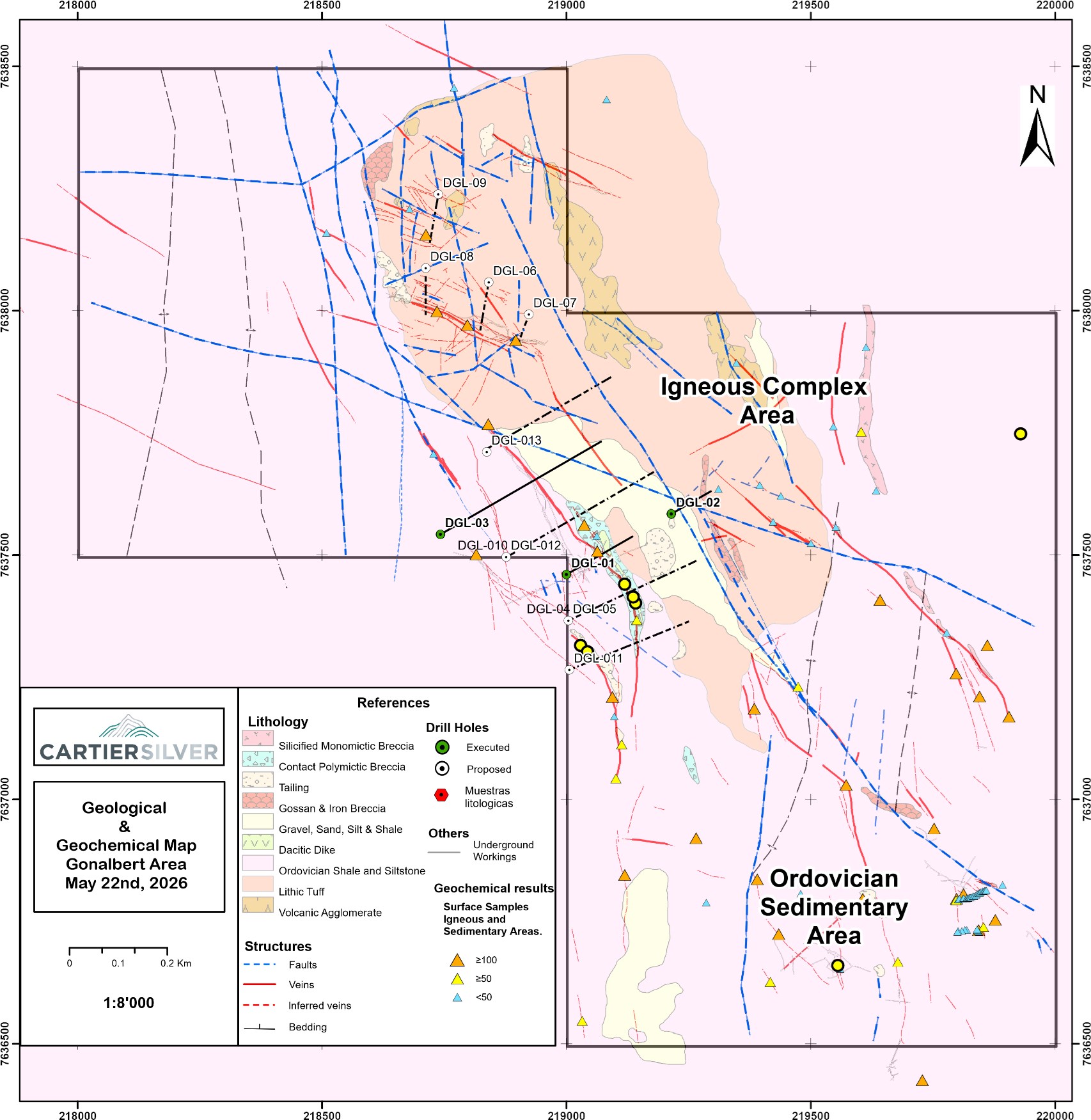
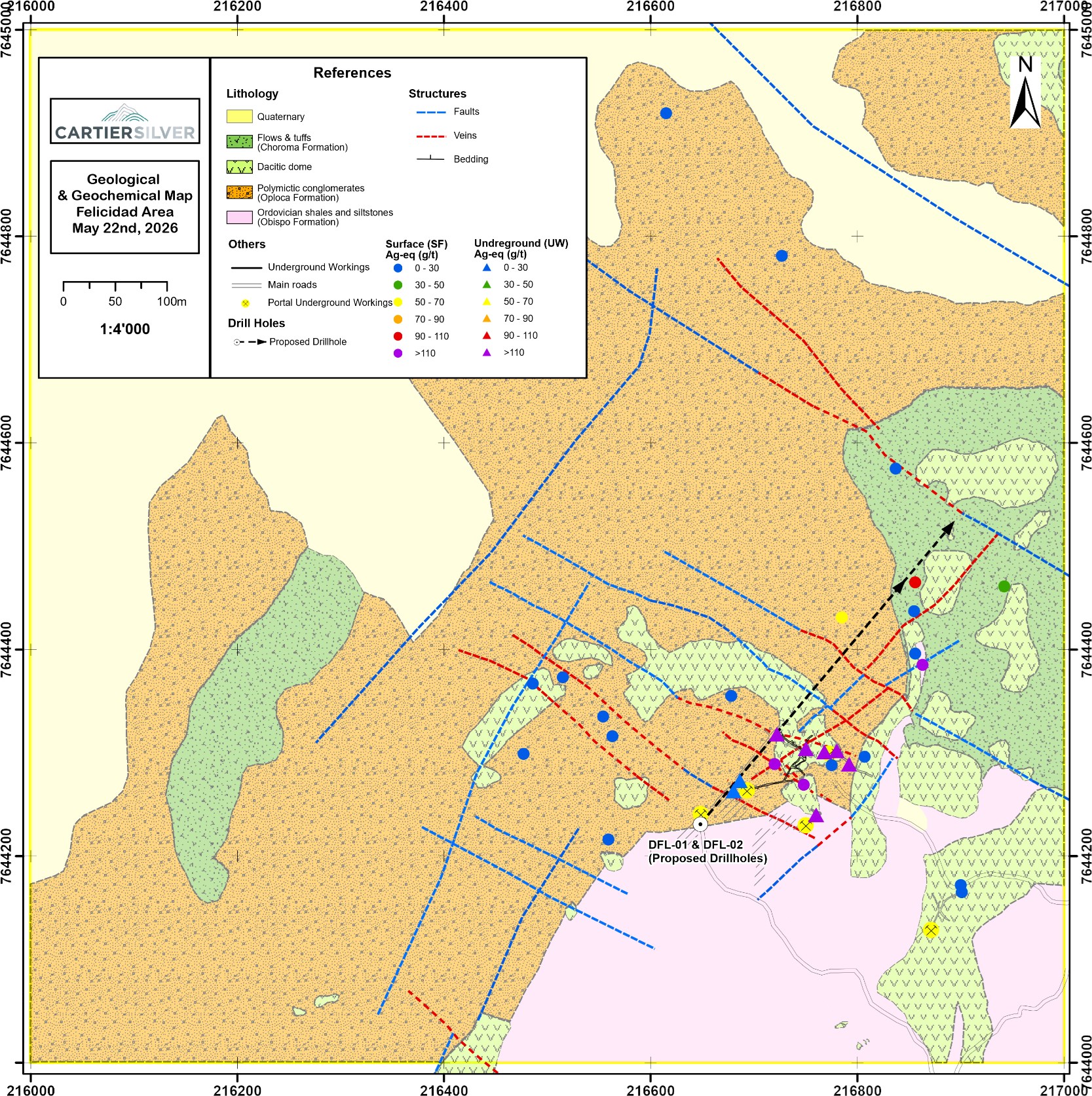
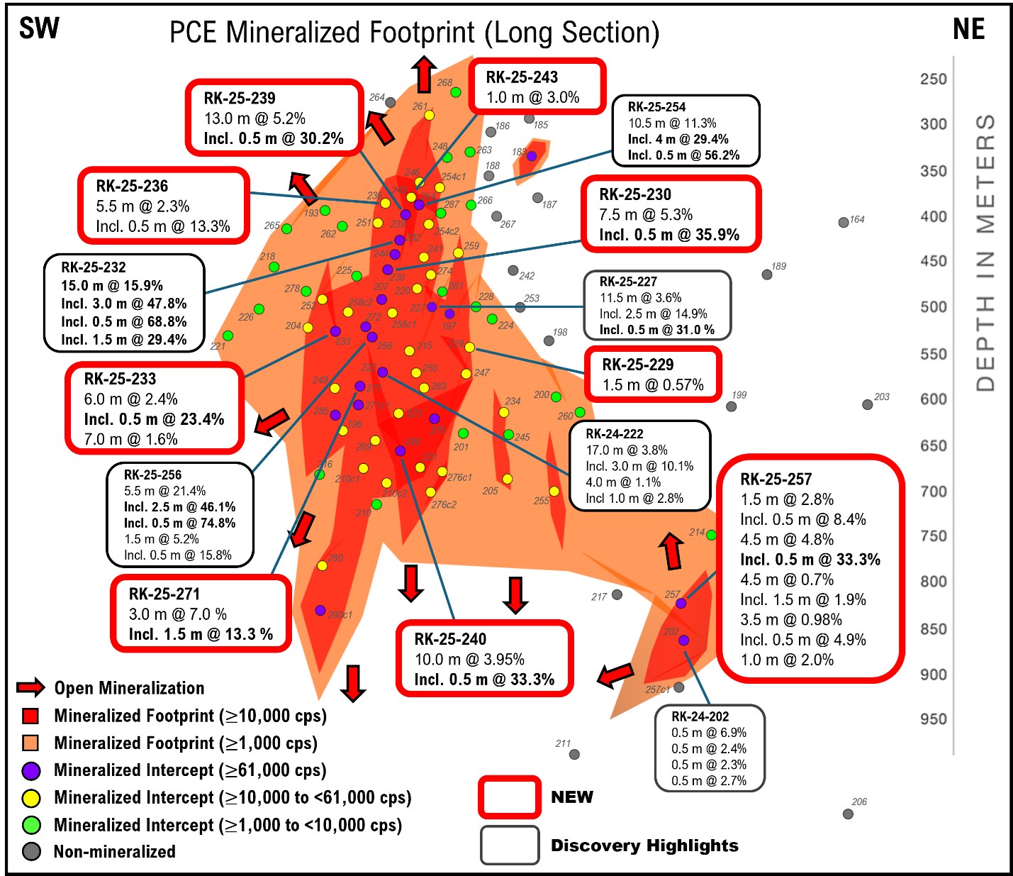
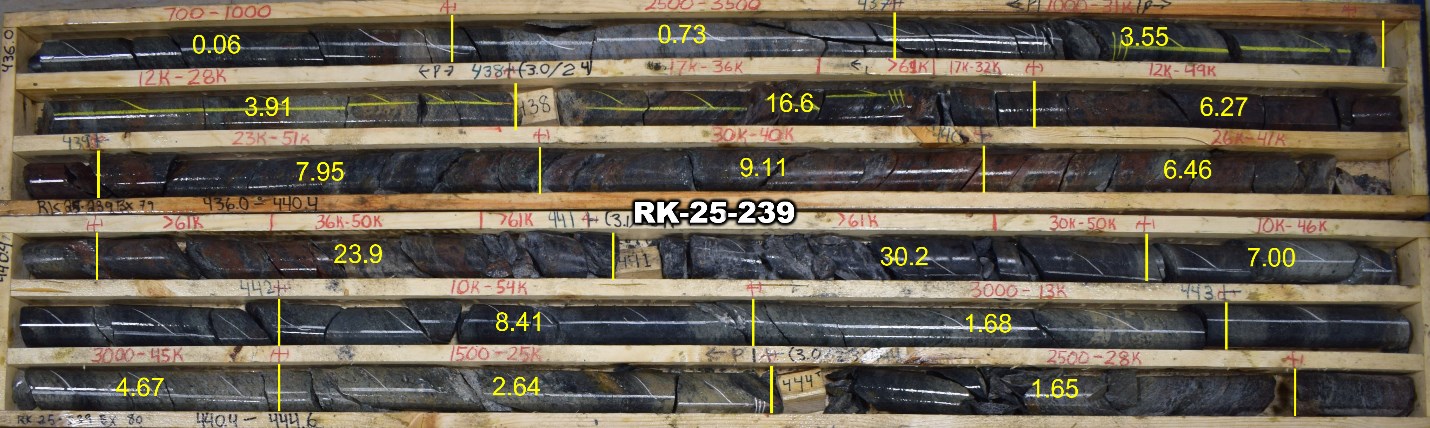
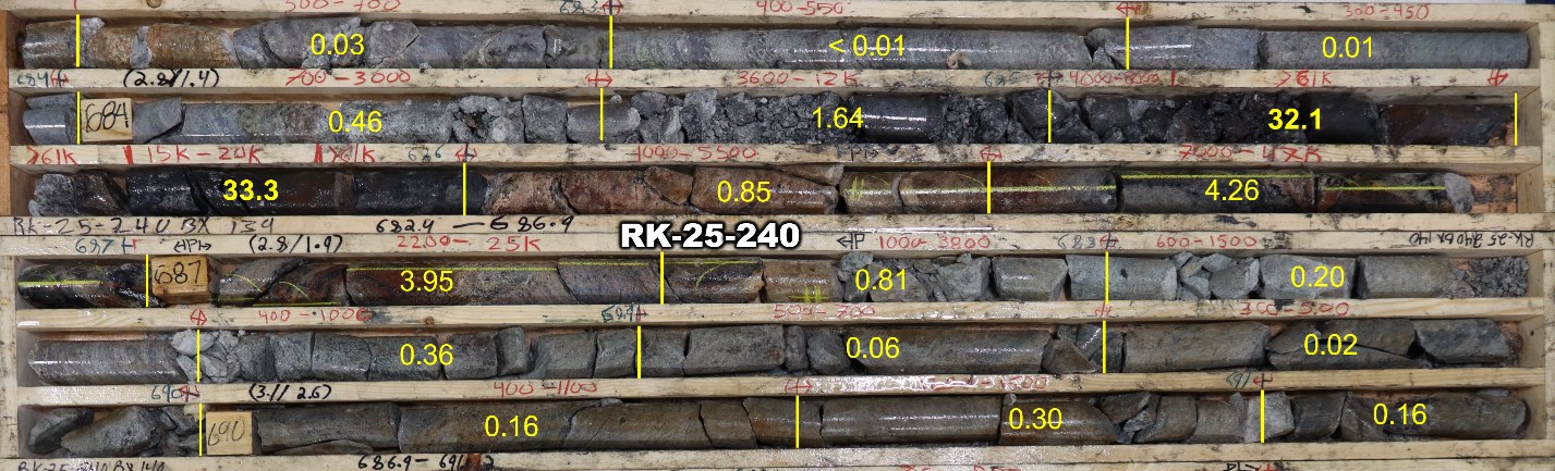
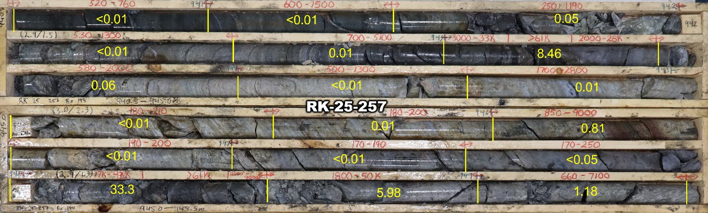
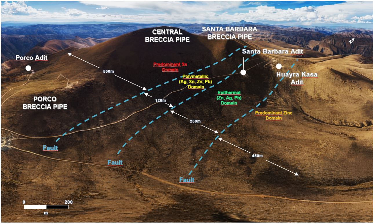
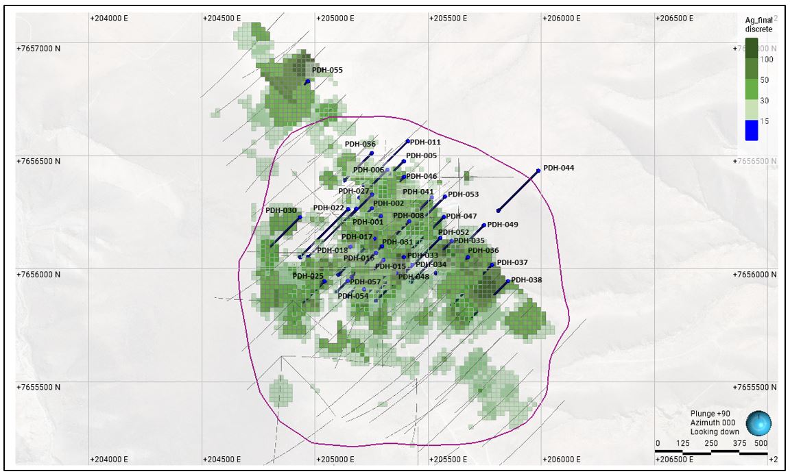
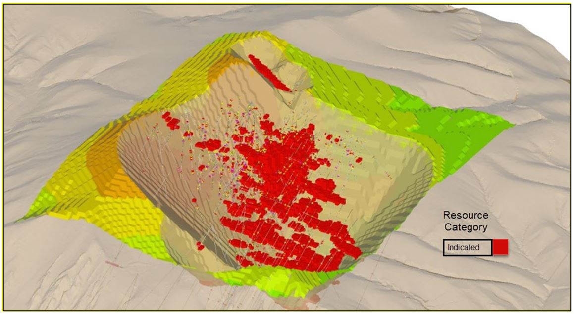
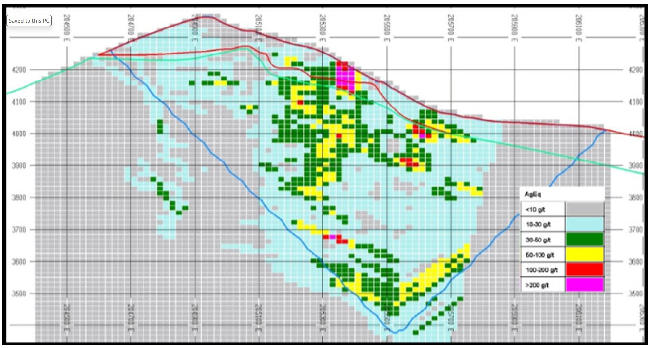
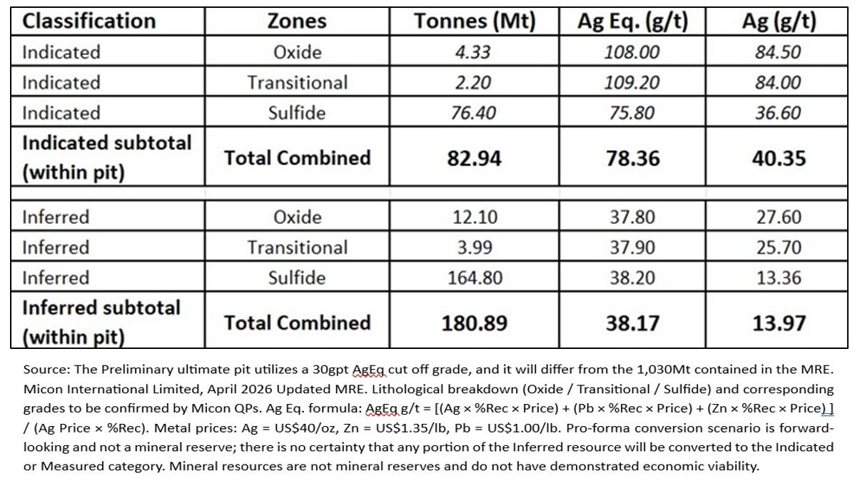
NexGen to Host Q1 2026 Conference Call
Vancouver, British Columbia–(Newsfile Corp. – May 5, 2026) – NexGen Energy Ltd. (TSX: NXE) (NYSE: NXE) (ASX: NXG) (“NexGen” or the “Company”) will host its 2026 first quarter conference call on Thursday, May 7, 2026, at 8:00 am Eastern Time.
During the call, NexGen’s Founder and Chief Executive Officer, Leigh Curyer, Chief Commercial Officer, Travis McPherson, Chief Financial Officer, Benjamin Salter, and Chris Copley, Project Director will provide an update on the site activities at NexGen’s 100% owned Rook I Project (the “Project“). Including the Company’s 2025 site infrastructure program, construction preparation, pending major contract announcements, timelines and procurement readiness, financing, the continued drilling success at Patterson Corridor East (“PCE”), and strengthening uranium market dynamics, alongside NexGen’s strategy to optimize value through maximizing leverage to future uranium prices.
Call-in Details:
Date: Thursday, May 7, 2026
Time: 8:00 am Eastern Time
Participants should advise the operator that they are joining the “NexGen Energy Ltd. Conference Call” to gain admission to the event:
North America Toll Free Number: 1-833-752-3734
Australia Local Toll Number: +61-7-3911-1378
Participants accessing the call via either of the provided links will be automatically connected to the NexGen Energy Ltd. Conference Call:
International HD Web Phone Access: Access Link
Call meTM : Call Me Link
Prior to the call, the Company will file its 2026 first quarter Financial Statements and Management Discussion & Analysis on Tuesday, May 5, 2026, after the North American markets close. These fillings will be available for review on the NexGen website under Reports and Filings and on the Company’s SEDAR+ profile at www.sedarplus.ca. In addition, a replay of the call will be available on the NexGen website under Events & Webcasts.
Further Information is available at www.nexgenenergy.ca.
About NexGen
NexGen Energy is a Canadian company focused on delivering clean energy fuel for the future. The Company’s flagship Rook I Project is being optimally developed into the largest low cost producing uranium mine globally, incorporating the most elite standards in environmental and social governance. The Rook I Project is supported by a NI 43-101 compliant Feasibility Study which outlines the elite environmental performance and industry leading economics. NexGen is led by a team of experienced uranium and mining industry professionals with expertise across the entire mining life cycle, including exploration, financing, project engineering and construction, operations and closure. NexGen is leveraging its proven experience to deliver a Project that leads the entire mining industry socially, technically and environmentally. The Project and prospective portfolio in northern Saskatchewan will provide generational long-term economic, environmental, and social benefits for Saskatchewan, Canada, and the world.
NexGen is listed on the Toronto Stock Exchange, the New York Stock Exchange under the ticker symbol “NXE” and on the Australian Securities Exchange under the ticker symbol “NXG” providing access to global investors to participate in NexGen’s mission of solving three major global challenges in decarbonization, energy security and access to power. The Company is headquartered in Vancouver, British Columbia, with its primary operations office in Saskatoon, Saskatchewan.
Contact Information
Leigh Curyer
Founder & Chief Executive Officer
NexGen Energy Ltd.
+1 604 428 4112
lcuryer@nxe-energy.ca
www.nexgenenergy.ca
Travis McPherson
Chief Commercial Officer
NexGen Energy Ltd.
+1 604 428 4112
tmcpherson@nxe-energy.ca
www.nexgenenergy.ca
Monica Kras
Vice President, Corporate Development
NexGen Energy Ltd.
+44 (0) 7307 191933
mkras@nxe-energy.ca
www.nexgenenergy.ca
Forward-Looking Information
The information contained herein contains “forward-looking statements” within the meaning of applicable United States securities laws and regulations and “forward-looking information” within the meaning of applicable Canadian securities legislation. “Forward-looking information” includes, but is not limited to, statements with respect to mineral reserve and mineral resource estimates, the 2021 Arrow Deposit, Rook I Project and estimates of uranium production, grade and long-term average uranium prices, anticipated effects of completed drill results on the Rook I Project, planned work programs, completion of further site investigations and engineering work to support basic engineering of the project and expected outcomes. Generally, but not always, forward-looking information and statements can be identified by the use of words such as “plans”, “expects”, “is expected”, “budget”, “scheduled”, “estimates”, “forecasts”, “intends”, “anticipates”, or “believes” or the negative connotation thereof or variations of such words and phrases or state that certain actions, events or results “may”, “could”, “would”, “might” or “will be taken”, “occur” or “be achieved” or the negative connotation thereof. Statements relating to “mineral resources” are deemed to be forward-looking information, as they involve the implied assessment that, based on certain estimates and assumptions, the mineral resources described can be profitably produced in the future.
Forward-looking information and statements are based on the then current expectations, beliefs, assumptions, estimates and forecasts about NexGen’s business and the industry and markets in which it operates. Forward-looking information and statements are made based upon numerous assumptions, including among others, that the mineral reserve and resources estimates and the key assumptions and parameters on which such estimates are based are as set out in this news release and the technical report for the property, the results of planned exploration activities are as anticipated, the price and market supply of uranium, the cost of planned exploration activities, that financing will be available if and when needed and on reasonable terms, that third party contractors, equipment, supplies and governmental and other approvals required to conduct NexGen’s planned exploration activities will be available on reasonable terms and in a timely manner and that general business and economic conditions will not change in a materially adverse manner. Although the assumptions made by the Company in providing forward-looking information or making forward-looking statements are considered reasonable by management at the time, there can be no assurance that such assumptions will prove to be accurate in the future.
Although the Company has attempted to identify important factors that could cause actual results to differ materially from those contained in the forward-looking information or statements or implied by forward-looking information or statements, there may be other factors that cause results not to be as anticipated, estimated or intended. Readers are cautioned not to place undue reliance on forward-looking information or statements due to the inherent uncertainty thereof.
There can be no assurance that forward-looking information and statements will prove to be accurate, as actual results and future events could differ materially from those anticipated, estimated or intended. Accordingly, readers should not place undue reliance on forward-looking statements or information. The Company undertakes no obligation to update or reissue forward-looking information as a result of new information or events except as required by applicable securities laws.
Eloro: Third largest in situ silver deposit in the world
Eloro Resources (ELO.T) put out a press release outlining its updated 43-101 Compliant Mineral Resource Estimate for its Iska Iska project in Bolivia. For the first time it was able to report “indicated” resources as well as significantly increased “inferred” resources.
ELO shares traded down.
I spoke to CEO Tom Larsen who was, as you might expect, disappointed with the market’s reception of what, objectively, is excellent news. Now part of the share price story is secular, the war in Iran, the price of silver falling; but part of it is the very nature of the 43-101 Mineral Resource process.
“So the actual Estimate is done by a third party,” said Larsen. “The independent mining consultant firm who have been hired for the inaugural 2023 MRE and the recent upgrade study is Micon International, an Independent Mining Consulting firm. They have to be conservative. Hundred meter by hundred meter drill spacings will always be classified as “inferred”. Fifty by fifty meter spacings are required for indicated.”
What Micon cannot comment on nor can Larsen, is the fact that the mineralization at Iska Iska has been remarkably consistent. Eloro has drilled to date 146 drill holes totalling 119,930 metres, every one of which has hit mineralization. It has developed a robust geological model of the drilled sections of the overall Iska Iska ground and is able to accurately discern well defined tin, lead/zinc and primary silver domains.
“The inferred silver resource in the upper part of the system in the 2023 MRE report reported 24 gram silver within 132 million tonnes,” said Larsen. “With our infill drilling in the last couple years we have moved to 85 million tons of indicated 40 gpt ton silver. The silver grade is up 66%.”
“We will be drilling up to 40,000 meters in the upcoming months,” said Larsen. “Primarily focused on the silver primary domain. We know that as we infill drill the grade goes up. By doing a focused infill drilling program we are confident we can take the indicated silver tons to 140 million at 40 grams per ton.”
40 grams is a tiny bit less than an ounce and a half. Here’s another thing which the 43-101 rules prohibit Eloro from including in the press release on the revised MRE: the value of 140 million tons of ounce and a half silver. Simple math with today’s silver price gives a gross value of US$ 10.5 billion. Ballpark cost of mining and processing at $20-25/ton leaves a profit of $50/ton or 7 billion US dollars. And that is just for the silver.
As I write, ELO’s market cap is 229 million Canadian or 167 million US. Little wonder that Larsen is disappointed with the market’s reaction to the revised MRE.
“We are going to focus on upgrading the silver primary,” said Larsen. “Iska Iska is the third largest in situ silver deposit in the world with in excess of 360 million ounces. We can increase the grade and the value of that deposit with minimal, but well targeted, drilling.”
At the same time Eloro will also be drilling in the tin domain to the West. “Right now, we have an inferred 31 million tons of tin at .2 percent,” said Larsen. “While our primary target is the silver, we will also drill the newly discovered tin corridor to the west of Santa Barbara to enhance the tin inferred resource as a potential standalone open pit mining operation. We would like to have drilled enough to include the tin resource as a sidebar in the upcoming Preliminary Economic Assessment.”
Eloro has faced obstacles in its drilling program in the last couple of years. Drill rigs not available and the diesel to run them being in short supply. However, the new Bolivian government has improved the diesel situation and ELO has retained a new drilling contractor. “We’ll have rigs running in early May,” said Larsen. “We plan on having three or four drills running as we progress.”
Polymetallic deposits are complicated and one as large as Iska Iska is difficult to explain to retail investors. Institutional investors, on the other hand, can digest and analyze the gist of the MRE. Here’s what Red Cloud had to say,
“We view this as a positive update that has resulted in a 54% increase in total mineralized tonnage. The higher confidence indicated resource exhibits a 65% higher grade compared to the high-grade portion of the 2023 MRE. As we had anticipated, the high-grade indicated portion (40 g/t Ag and 75.2 g/t AgEq) lies in the middle of the resource pit shell. We believe the high-grade core should dispel concerns about the potential quality of the deposit while its size, geometry and continuity remain key defining attributes that place Iska Iska among the premier Ag dominant development projects globally.”
As investment bankers are wont to do, Red Cloud compared Eloro’s $0.18 US per in situ ounce valuation with ten peers which had an average in situ silver ounce valuation of $1.93 US. Unsurprisingly, Red Cloud is looking for a $5.50 target price.
Along with capital markets people, Eloro is also attracting the attention of large balance sheet companies. “We have four NDAs in place,” said Larsen while declining to actually name the entities involved.
Taking a strategic stake in Eloro or buying some or all of the Iska Iska deposit or joint venturing are all potential outcomes for ELO’s suitors. At the moment there has to be a serious temptation to put in a stink bid at, say, $4.00 (less than $500 million) Canadian to get an asset the silver value of which, net, is on the order of 7 billion dollars. Such a bid would kick off a competition and it is a good bet the final offer would leave Red Cloud’s $5.50 target in the dust.
The next major event for Eloro will be its PEA expected Q4 2026. Chances are pretty good that PEA will include a further revised MRE based on the drilling at Iska Iska starting in the next couple of weeks. In the PEA Eloro will be allowed to attach some actual economics to the geology. Mining and processing costs, recoveries and sensitivity tables reflecting the effect of the price of silver and the other metals. Plus, if the drilling goes well, the tin domain’s value will be reflected as well.
Cartier Cuts 7.9 g/t Au Over 4.0 m Within A Broader Segment of 2.3 g/t Au Over 19.0 m at Hope Sector (Cadillac); Unlocks New High-Grade Gold Zone in Underexplored Pontiac Sediments
Cartier Resources Inc. (″ Cartier ″ or the ″ Company ″) (TSXV: ECR; FSE: 6CA) is pleased to announce the eleventh batch of results from the 100,000-m drilling program (2 drill rigs), within the underexplored Pontiac sedimentary Group in Hope Sector, on the 100%-owned Cadillac Project, located in Val-d’Or (Abitibi, Quebec).
Strategic Highlights from Hope Sector
Drill Hole Results (Figures 1 to 3)
New Zones
- CA26-591 reported 7.9 g/t Au over 4.0 m included in 2.3 g/t Au over 19.0 m, with visible gold grains.
- CA26-334 graded 7.8 g/t Au over 1.0 m included in 2.3 g/t Au over 4.0 m.
- CA26-335 intersected 3.1 g/t Au over 3.0 m included in 1.1 g/t Au over 11.0 m.
Porphyry #1 Zone
- CA26-334 reported 6.2 g/t Au over 1.0 m included in 2.7 g/t Au over 3.0 m.
Significance for Investors
- Hole CA26-591 introduces a new high-grade gold zone near surface in the unexplored Pontiac sediments. The intersection is located south of the Cadillac Fault and 50 m south of the Porphyry #2 intrusion, which opens an entirely new exploration target.
- This new discovery closely resembles the gold mineralization in the Cadillac sediments, consisting of a stockwork of quartz-carbonate veins and veinlets accompanied by sulfides and visible gold grains. To date, only two holes have tested this discovery, demonstrating the mineralized zone is open in all directions and at depth, and signaling significant exploration potential.
- Drill holes CA26-334 and 335 intersected the Porphyry #1 intrusion, extending its westward dimension to at least 1 km in length, remains open at depth and suggests a sizeable intrusive system in play.
- The two mineralization styles (sediment-hosted gold and porphyry-related gold systems) elevate the Hope Sector as a highly strategic area for the Cadillac project, despite its early-stage exploration status, highlighting its strong potential for new gold discoveries.
Next Steps
- Further expansion drilling is being planned at the Hope Sector to unlock the full potential of these two new styles of mineralization (sediments and porphyries).
- Additional exploration drilling is already planned to test two new high-priority geophysical targets, namely:
- A 1,500 m strong chargeability anomaly, between the existing porphyry zones to test the expansion potential of the mineralized system or a new porphyry center;
- A 750 m ovoid magnetic anomaly, consistent with a sizable intrusive body often associated with porphyry mineralization.
” This second set of results underscores the emerging significance of the Hope sector, which remains at an early stage of development with considerable exploration runway ahead. The confirmation of a porphyry intrusion-related gold system (Porphyries #1 and #2) and a sediment-hosted gold mineralization, materially enhances the geological prospectivity of the Cadillac project. These discoveries point to the presence of multiple mineralizing systems, increasing the potential for scale and supporting a more diversified exploration model. With a footprint of approximately 30 km², the Hope Sector represents a meaningful growth opportunity, offering strong upside leverage through continued exploration, potential resource delineation, and long-term value creation. ” – Philippe Cloutier, President and CEO of Cartier.
” The underexplored Pontiac region represents a compelling opportunity for discovery, with strong indications of multiple gold-bearing lithologies, including porphyritic intrusions and sedimentary units. Over the coming months, an expanded drilling program will systematically evaluate the Pontiac land package, targeting new zones of gold mineralization and testing high-priority anomalies. This program is designed to unlock additional resource potential, drive new discoveries, and meaningfully enhance the overall value of the project. ” – Ronan Deroff, Vice President Exploration of Cartier.
Table 1: Drill hole best assay results from Hope Sector
| Hole Number | From (m) | To (m) | Core Length** (m) | Au (g/t) Uncut | Vertical Depth (m) | Zone |
| CA26-334 | 173.0 | 177.0 | 4.0 | 2.3 | ≈160 | – |
| Including | 173.0 | 174.0 | 1.0 | 7.8 | ||
| And | 313.0 | 316.0 | 3.0 | 2.7 | ≈280 | Porphyry #1 |
| Including | 314.0 | 315.0 | 1.0 | 6.2 | ||
| CA26-335 | 157.0 | 168.0 | 11.0 | 1.1 | ≈150 | – |
| Including | 157.0 | 160.0 | 3.0 | 3.1 | ||
| CA26-591 | 257.0 | 276.0 | 19.0 | 2.3* | ≈190 | – |
| Including | 272.0 | 276.0 | 4.0 | 7.9 |
* Occurrences of visible gold (VG) have been noted in the drill core at various intervals. ** Based on the observed intercept angles within the drill core, true thicknesses are estimated to represent approximately 60-90% of the reported core length intervals.
Figure 1: Location of the new drill results (regional plan view)

Figure 2: Plan view, cross and long sections of the Hope Sector

Figure 3: Photos of the drill core from hole CA26-591

Hope Sector
The Hope Sector is a newly identified highly prospective area and untested conceptual exploration opportunity, situated immediately south of the prolific Cadillac Fault, with potential to host a new style of gold mineralization (intrusion-related gold deposits) within the underexplored Pontiac sedimentary Group, supporting significant discovery upside. The known presence of the porphyritic felsic intrusion is a favorable horizon for hydrothermal fluid flow. This sector hosts several new high-priority drill targets identified through geoscientific compilation and modelling.
The Hope Sector, defined by at least two porphyry mineralized systems, are typically and primarily associated with a fine-grained and disseminated pyrite-pyrrhotite mineralization, with a pervasive silica-biotite-sericite-carbonate alteration, all crosscut by late-stage smoky and white quartz vein and veinlet stockworks containing visible gold. Locally, accessory minerals such as tourmaline are observed.
Milestones of 2025-2027 Exploration Program
100,000 m Drilling Program (Q3 2025 to Q2 2027)
The ambitious 600-hole drilling program will both expand known gold zones and test new shallow surface high-potential targets. The objective is to unlock the camp-scale, high-grade gold potential along the 15 km Cadillac Fault Zone. It is important to note that Cartier’s recent consolidation of this large land holding offers the unique opportunity in over 90 years for unrestricted exploration.
Environmental Baseline Studies & Economic Evaluation of Chimo mine tailings (Q3 2025 to Q3 2026)
The baseline studies will be divided into two distinct parts which include 1) environmental baseline desktop study and 2) preliminary environmental geochemical characterization. The initial baseline studies will provide a comprehensive understanding of the current environmental conditions and implement operations that minimize environmental impact while optimizing the economic potential of the project. These studies will be supplemented by an initial assessment of the economic potential of the past-producing Chimo mine tailings to determine whether a quantity of gold can be extracted economically.
Metallurgical Sampling and Testwork Program (Q4 2025 to Q1 2026)
The metallurgical testwork program includes defining of expected gold recovery rates and improving historical results from the Chimo deposit, as well as establishing metallurgical recovery data for the first-time for the East Chimo and West Nordeau satellite deposits, where no previous data exists. This comprehensive program will characterize the mineralized material, gold recovery potential and validate optimal grind size defining the most efficient and cost-effective flowsheet. The data generated will directly support optimized project development and have the potential to significantly reduce both capital and operating costs, while also improving the environmental footprint.
Table 2: Drill hole collar coordinates from Hope Sector
| Hole Number | UTM Easting (m) | UTM Northing (m) | Elevation (m) | Azimuth (°) | Dip (°) | Hole Length (m) |
| CA26-334 | 331052 | 5319918 | 340 | 225 | -64 | 336 |
| CA26-335 | 331052 | 5319918 | 340 | 180 | -72 | 348 |
| CA26-591 | 333593 | 5319172 | 347 | 190 | -44 | 300 |
Table 3: Drill hole detailed assay results from Hope Sector
| Hole Number | From (m) | To (m) | Core Length* (m) | Au (g/t) Uncut | Vertical Depth (m) | Zone |
| CA26-334 | 173.0 | 177.0 | 4.0 | 2.3 | ≈160 | – |
| Including | 173.0 | 174.0 | 1.0 | 7.8 | ||
| And | 195.0 | 197.0 | 2.0 | 2.6 | ≈175 | – |
| Including | 195.0 | 196.0 | 1.0 | 2.8 | ||
| Including | 196.0 | 197.0 | 1.0 | 2.4 | ||
| And | 212.0 | 213.0 | 1.0 | 1.6 | ≈190 | – |
| And | 224.1 | 225.1 | 1.0 | 1.0 | ≈200 | – |
| And | 313.0 | 316.0 | 3.0 | 2.7 | ≈280 | Porphyry #1 |
| Including | 313.0 | 314.0 | 1.0 | 1.2 | ||
| Including | 314.0 | 315.0 | 1.0 | 6.2 | ||
| CA26-335 | 157.0 | 168.0 | 11.0 | 1.1 | ≈150 | – |
| Including | 157.0 | 158.0 | 1.0 | 4.8 | ||
| Including | 159.0 | 160.0 | 1.0 | 4.0 | ||
| Including | 164.0 | 165.0 | 1.0 | 1.0 | ||
| And | 213.7 | 214.8 | 1.1 | 5.3 | ≈200 | – |
| CA26-591 | 147.5 | 148.5 | 1.0 | 2.9 | ≈110 | – |
| And | 163.0 | 164.0 | 1.0 | 1.1 | ≈120 | – |
| And | 257.0 | 276.0 | 19.0 | 2.3 | ≈190 | – |
| Including | 257.0 | 258.0 | 1.0 | 1.6 | ||
| Including | 258.0 | 259.0 | 1.0 | 4.8 | ||
| Including | 259.0 | 260.0 | 1.4 | 2.4* | ||
| Including | 272.0 | 273.0 | 1.0 | 22.0 | ||
| Including | 273.0 | 274.0 | 1.0 | 2.4 | ||
| Including | 274.0 | 275.0 | 1.0 | 3.3 | ||
| Including | 275.0 | 276.0 | 1.0 | 3.9 |
* Occurrences of visible gold (VG) have been noted in the drill core at various intervals. ** Based on the observed intercept angles within the drill core, true thicknesses are estimated to represent approximately 60-90% of the reported core length intervals.
Quality Assurance and Quality Control (QA/QC) Program
The drill core from the Cadillac Project is NQ-size and, upon receipt from the drill rig, is described and sampled by Cartier geologists. Core is sawn in half, with one half labelled, bagged and submitted for analysis and the other half retained and stored at Cartier’s coreshack facilities located in Val-d’Or, Quebec, for future reference and verification. As part of Quality Assurance and Quality Control (QA/QC) program, Cartier inserts blank samples and certified reference materials (standards) at regular intervals into the sample stream prior to shipment to monitor laboratory performance and analytical accuracy.
Drill core samples are sent to MSALABS’s analytical laboratory located in Val-d’Or, Quebec, for preparation and gold analysis. The entire sample is dried and crushed (70% passing a 2-millimeter sieve). The analysis for gold is performed on an approximately 500 g aliquot using Chrysos Photon Assay™ technology, which uses high-energy X-ray excitation with gamma detection to quickly and non-destructively measure gold content.
Alternatively, samples are submitted to Activation Laboratories Ltd. (“Actlabs”), located in either Val-d’Or or Ste-Germaine-Boulé, both in Quebec, for preparation and gold analysis. The entire sample is dried, crushed (90% passing a 2-millimetre sieve) and 250 g is pulverized (90% passing a 0.07-millimetre sieve). The analysis for gold is conducted using a 50 g fire assay fusion with atomic absorption spectroscopy (AAS) finish, with a detection limit up to 10,000 ppb. Samples exceeding this threshold are reanalyzed by fire assay with a gravimetric finish to determine high-grade values accurately.
Both MSALABS and Actlabs are ISO/IEC 17025 accredited for gold assays and implement industry-standard QA/QC protocols. Their internal quality control programs include the use of blanks, duplicates, and certified reference materials at set intervals, with established acceptance criteria to ensure data integrity and analytical precision.
Qualified Person
The scientific and technical content of this press release has been prepared, reviewed and approved by Mr. Ronan Déroff, P.Geo., M.Sc., Vice President Exploration, who is a ″ Qualified Person ″ as defined by National Instrument 43-101 – Standards of Disclosure for Mineral Projects (″ NI 43-101 ″).
About Cadillac Project
The Cadillac Project, covering 14,000 hectares along a 15-kilometre stretch of the Cadillac Fault, is one of the largest consolidated land packages in the Val-d’Or mining camp. Cartier’s flagship asset integrates the historic Chimo Mine and East Cadillac projects, creating a dominant position in a world class gold mining district. With excellent road access, year-round infrastructure and nearby milling capacity, the project is ideally positioned for rapid advancement and value creation.
The Cadillac property contains total gold resource of 767,800 ounces in the measured and indicated category (10.0 Mt at 2.4 g/t Au) and 2,416,900 ounces in the inferred category (35.2 Mt at 2.1 g/t Au) across all the sectors. Please see the ″ NI 43-101 Technical Report and Mineral Resource Estimate on the Cadillac Project, Val-d’Or, Abitibi, Quebec, Canada. Pierre-Luc Richard, P.Geo. of PLR Resources Inc., Stephen Coates, P.Eng. of Evomine Consulting Inc. and Florent Baril, P.Eng. of Bumigeme Inc. ″, effective January 27, 2026.
About Cartier Resources Inc.
Cartier Resources Inc., founded in 2006 and headquartered in Val-d’Or (Quebec) is a gold exploration company focused on building shareholder value through discovery and development in one of Canada’s most prolific mining camps. The Company combines strong technical expertise and a track record of successful exploration to advance its flagship Cadillac Project. Cartier’s strategy is clear: unlock the full potential of one of the largest undeveloped gold landholdings in Quebec.
For further information, contact:
Philippe Cloutier, P. Geo.
President and CEO
Telephone: 819-856-0512
philippe.cloutier@ressourcescartier.com
www.ressourcescartier.com
NexGen Announces Expansion of High-Grade Zone at Patterson Corridor East (PCE) and the Completion of 2026 Winter Drill Program
NexGen Energy Ltd. (TSX: NXE) (NYSE: NXE) (ASX: NXG) (“NexGen” or the “Company”) announces results from the 2026 winter drill program at Patterson Corridor East (“PCE”) that recently concluded, highlighting significant vertical growth and strong internal continuity of high-grade mineralization.
Within the mineralized zone of PCE, the high-grade subdomain has now grown to 550 m in vertical extent, a 33% increase, with a strike length of 210 m. This expansion was primarily driven by hole RK-26-280c1 which returned cumulative 4.2m of >10,000 cps including 0.6m of >61,000 cps at 834m below surface (Figures 1-3). The hole successfully intersected mineralization 230m down plunge along a high-grade shoot interpreted to connect with RK-26-271c1 (Figure 4).
Holes RK-26-271c1, RK-26-276, and RK-26-285 returned strong mineralized intercepts between 600 to 700m below surface, where the system remains open for expansion (Figures 1 and 2, Table 1). Results from RK-26-271c1 include cumulative 12.6m of >10,000 cps including 2.3m of >61,000 cps 80m down plunge of RK-25-256 (5.5m at 21.4% U3O8) indicating continuity of intense high-grade mineralization (Figure 3). Further, the intersections from RK-26-276 (cumulative 11.2m of >10,000 cps including 0.6m of >61,000 cps) and RK-26-285 (cumulative 9.0m of >10,000 cps including 0.7m of >61,000 cps) add progressive high-grade continuity to the base of this growing subdomain.
Drilling 600m to the southeast of PCE along a separate parallel trend, prospective structure and alteration features are vectoring the Company toward potential repetition of mineralization within the overall PCE system (Figure 5).
Summer drilling of ~29,200m is schedule to commence the week of May 25, 2026. All samples from 2026 drilling are submitted to the independent Saskatchewan Research Council Geoanalytical Laboratory (SRC), with results to follow.
Leigh Curyer, Founder & Chief Executive Officer, commented: “Today’s results from the 2026 winter program confirm both the scale and growth of PCE continues to advance at pace. Increasing the vertical extent of the high-grade subdomain by 33% during the winter program, suggests substantial drilling is required going forward to fully understand the extent of this mineralized zone. In parallel, drilling focused on vectoring into additional zones of mineralization will be incorporated into the summer program based on these winter results.
“With the Rook I Project commencing construction this summer and the significance of PCE materializing rapidly, we look forward to future drilling and evaluation of PCE and its potential position in the long-term profile of NexGen’s uranium portfolio. NexGen is positioned to meet the strong demand for Canadian uranium for many decades into the future, whilst setting a new industry standard in the safe, efficient and reliable delivery of offtake to utility customers around the world.”
A total of 12,758.2m of the planned 42,000m has been completed in 2026, focusing on high-grade growth and expansion of mineralization. Thirteen drill holes totalling 9,131.7m were dedicated to advancing the mineralization at PCE and six drill holes totalling 3,626.5m tested the parallel trend. Since discovery (see news release date March 11, 2024), 115 drillholes totalling 72,464.7m targeted PCE mineralization (Figure 4) with 79 of the 115 drill holes being mineralized, including 54 intersecting high-grade (>10,000 cps) and 21 intersecting off-scale (>61,000 cps).

Figure 1: Interpreted 3D model of PCE shown looking northwest (across strike) and northeast (along strike); previously reported in December 1, 2025 release, now with RK-26-271c1, RK-26-276, RK-26-280c1, and RK-26-285 intersections outlined in purple
To view an enhanced version of this graphic, please visit:
https://images.newsfilecorp.com/files/1745/293775_f571136e943028da_002full.jpg
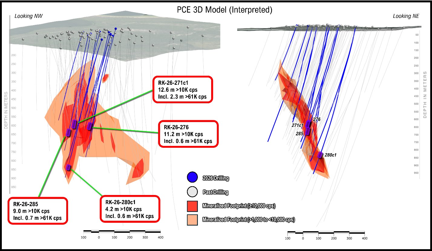

Figure 2: Interpreted model of mineralization at PCE (as of this release); new holes emphasized by larger diameter pierce points and bold labels; view is a long section that looks perpendicular to the primary mineralized plane; total mineralized footprint in orange and the high-grade subdomains in red
To view an enhanced version of this graphic, please visit:
https://images.newsfilecorp.com/files/1745/293775_f571136e943028da_003full.jpg
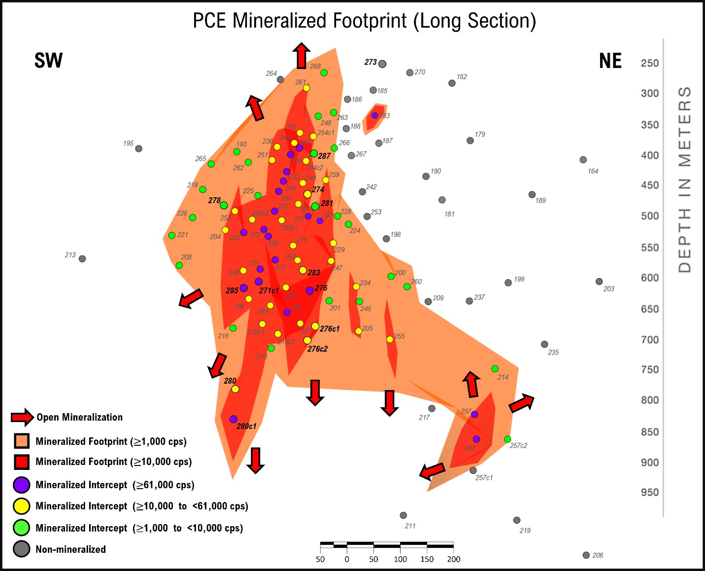

Figure 3: Core photo from RK-25-280c1 displays semi-massive, off-scale (>61,000 cps) from uranium vein at 834m down hole
To view an enhanced version of this graphic, please visit:
https://images.newsfilecorp.com/files/1745/293775_f571136e943028da_004full.jpg
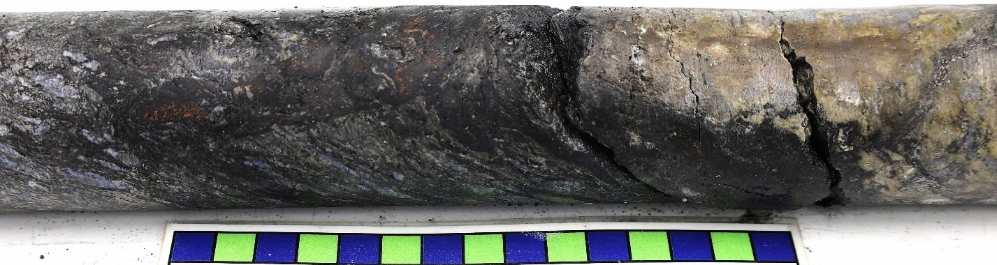

To view an enhanced version of this graphic, please visit:
https://images.newsfilecorp.com/files/1745/293775_f571136e943028da_005full.jpg
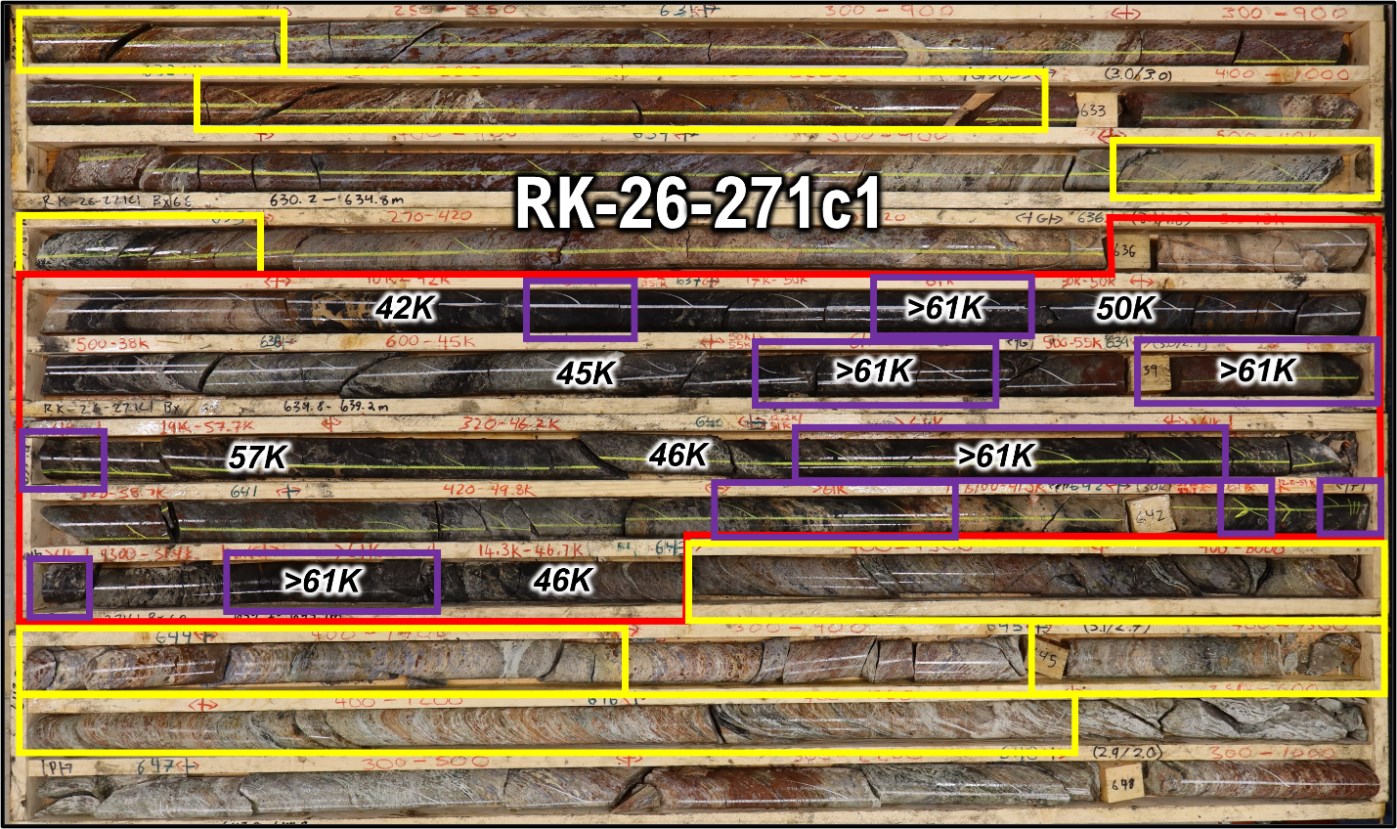

Figure 5: Map of PCE with completed 2026 drill holes; ground gravity in background, interpreted fault shown as black dashed line
To view an enhanced version of this graphic, please visit:
https://images.newsfilecorp.com/files/1745/293775_f571136e943028da_006full.jpg
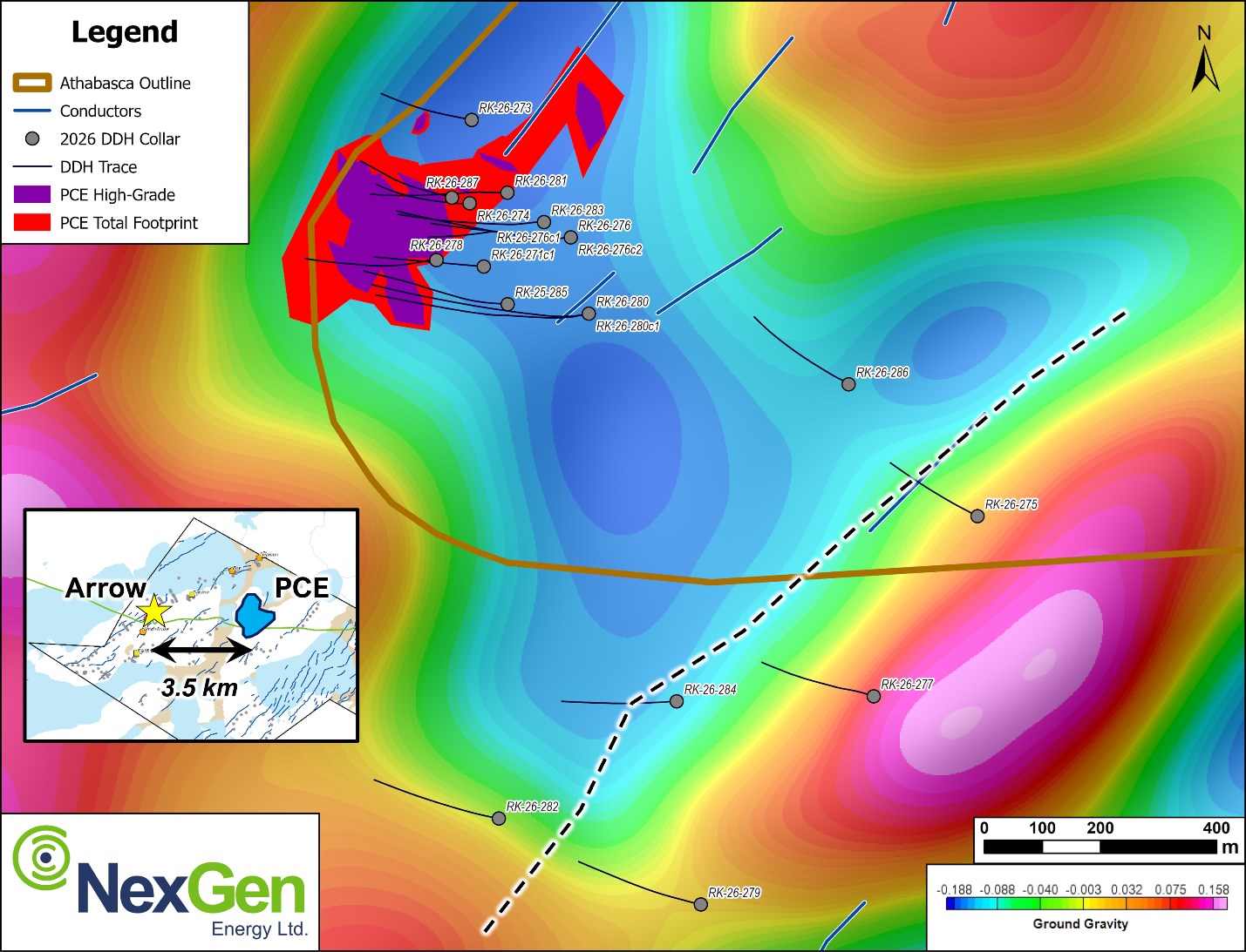
Table 1: Spectrometer results since January 15, 2026 release
| Drillhole | Unconformity Depth (m) | Handheld Spectrometer Results (RS-125) | ||||||
| Hole ID | Azimuth | Dip | Total Depth (m) | From (m) | To (m) | Width (m) | CPS Range | |
| RK-26-271c1 | 275 | -75 | 730.0 | – | 615.0 | 616.5 | 1.5 | <500 |
| 618.0 | 619.0 | 1.0 | <500 | |||||
| 619.5 | 627.5 | 8.0 | <500 | |||||
| 627.5 | 627.7 | 0.2 | 600 – 2000 | |||||
| 627.7 | 627.8 | 0.1 | >61000 | |||||
| 627.8 | 628.0 | 0.2 | 800 – 3000 | |||||
| 628.0 | 630.0 | 2.0 | <500 | |||||
| 630.0 | 630.5 | 0.5 | <500 – 1400 | |||||
| 630.5 | 631.0 | 0.5 | <500 | |||||
| 631.0 | 632.0 | 1.0 | <500 – 900 | |||||
| 632.0 | 632.5 | 0.5 | 600 – 1200 | |||||
| 632.5 | 633.0 | 0.5 | <500 – 2200 | |||||
| 633.0 | 633.5 | 0.5 | <500 – 1000 | |||||
| 633.5 | 634.5 | 1.0 | <500 – 900 | |||||
| 634.5 | 635.0 | 0.5 | 500 – 40000 | |||||
| 635.0 | 635.5 | 0.5 | <500 | |||||
| 635.5 | 636.0 | 0.5 | <500 – 720 | |||||
| 636.0 | 636.5 | 0.5 | 500 – 13000 | |||||
| 636.5 | 636.8 | 0.3 | 10000 – 42000 | |||||
| 636.8 | 636.9 | 0.1 | >61000 | |||||
| 636.9 | 637.0 | 0.1 | 24000 – 35000 | |||||
| 637.0 | 637.2 | 0.2 | 17000 – 50000 | |||||
| 637.2 | 637.4 | 0.2 | >61000 | |||||
| 637.4 | 637.5 | 0.1 | 30000 – 50000 | |||||
| 637.5 | 638.0 | 0.5 | 500 – 38000 | |||||
| 638.0 | 638.5 | 0.5 | 600 – 45000 | |||||
| 638.5 | 638.6 | 0.1 | 50000 – 55000 | |||||
| 638.6 | 638.9 | 0.3 | >61000 | |||||
| 638.9 | 639.0 | 0.1 | 500 – 55000 | |||||
| 639.0 | 639.3 | 0.3 | >61000 | |||||
| 639.3 | 639.5 | 0.2 | 19000 – 57700 | |||||
| 639.5 | 640.0 | 0.5 | <500 – 46200 | |||||
| 640.0 | 640.1 | 0.1 | 12200 – 51000 | |||||
| 640.1 | 640.6 | 0.5 | >61000 | |||||
| 640.6 | 641.0 | 0.4 | <500 – 58700 | |||||
| 641.0 | 641.5 | 0.5 | <500 – 49800 | |||||
| 641.5 | 641.8 | 0.3 | >61000 | |||||
| 641.8 | 642.0 | 0.2 | 6700 – 41300 | |||||
| 642.0 | 642.1 | 0.1 | >61000 | |||||
| 642.1 | 642.2 | 0.1 | 12200 – 51000 | |||||
| 642.2 | 642.3 | 0.1 | >61000 | |||||
| 642.3 | 642.4 | 0.1 | 9300 – 51400 | |||||
| 642.4 | 642.7 | 0.3 | >61000 | |||||
| 642.7 | 643.0 | 0.3 | 14300 – 46700 | |||||
| 643.0 | 643.5 | 0.5 | <500 – 7300 | |||||
| 643.5 | 644.0 | 0.5 | <500 – 8000 | |||||
| 644.0 | 644.5 | 0.5 | <500 – 1400 | |||||
| 644.5 | 645.0 | 0.5 | <500 | |||||
| 645.0 | 645.5 | 0.5 | <500 – 1300 | |||||
| 645.5 | 646.5 | 1.0 | <500 – 1200 | |||||
| 646.5 | 647.0 | 0.5 | <500 – 600 | |||||
| 647.0 | 647.5 | 0.5 | <500 | |||||
| 647.5 | 648.0 | 0.5 | <500 – 2200 | |||||
| 648.0 | 648.5 | 0.5 | <500 – 1000 | |||||
| 648.5 | 649.0 | 0.5 | <500 – 8000 | |||||
| 649.0 | 649.5 | 0.5 | 3000 – 10000 | |||||
| 649.5 | 650.0 | 0.5 | 3000 – 22000 | |||||
| 650.0 | 650.5 | 0.5 | <500 – 7000 | |||||
| 650.5 | 653.0 | 2.5 | <500 | |||||
| 653.0 | 653.5 | 0.5 | <500 – 900 | |||||
| 653.5 | 654.0 | 0.5 | <500 | |||||
| 654.0 | 655.0 | 1.0 | 600 – 12000 | |||||
| 655.0 | 655.5 | 0.5 | 500 – 7000 | |||||
| 655.5 | 656.0 | 0.5 | 500 – 1600 | |||||
| 656.0 | 656.5 | 0.5 | <500 – 2200 | |||||
| 656.5 | 657.0 | 0.5 | <500 – 800 | |||||
| 657.0 | 657.5 | 0.5 | <500 – 700 | |||||
| 657.5 | 658.0 | 0.5 | <500 | |||||
| 658.0 | 658.5 | 0.5 | <500 – 600 | |||||
| 658.5 | 659.0 | 0.5 | <500 – 900 | |||||
| 659.0 | 660.0 | 1.0 | <500 | |||||
| 660.0 | 660.5 | 0.5 | <500 – 1100 | |||||
| 660.5 | 661.0 | 0.5 | <500 – 800 | |||||
| 661.0 | 661.5 | 0.5 | <500 – 1300 | |||||
| 661.5 | 662.0 | 0.5 | <500 | |||||
| 662.0 | 662.5 | 0.5 | <500 – 1000 | |||||
| 662.5 | 663.0 | 0.5 | <500 – 9500 | |||||
| 663.0 | 663.5 | 0.5 | <500 – 650 | |||||
| 663.5 | 665.5 | 2.0 | <500 | |||||
| 665.5 | 666.0 | 0.5 | <500 – 2200 | |||||
| 666.0 | 666.5 | 0.5 | <500 – 1500 | |||||
| 670.5 | 671.0 | 0.5 | <500 – 18300 | |||||
| 671.0 | 671.5 | 0.5 | <500 – 6100 | |||||
| 671.5 | 672.0 | 0.5 | 570 – 32400 | |||||
| 672.0 | 672.5 | 0.5 | <500 – 4100 | |||||
| 672.5 | 673.0 | 0.5 | <500 – 7100 | |||||
| 673.0 | 673.5 | 0.5 | <500 – 3800 | |||||
| 674.0 | 674.5 | 0.5 | <500 – 530 | |||||
| 674.5 | 675.0 | 0.5 | <500 – 650 | |||||
| 675.5 | 676.0 | 0.5 | <500 – 900 | |||||
| 676.0 | 676.5 | 0.5 | <500 | |||||
| 677.0 | 677.5 | 0.5 | <500 | |||||
| 678.5 | 679.5 | 1.0 | <500 | |||||
| 679.5 | 680.0 | 0.5 | <500 – 22800 | |||||
| 680.0 | 680.5 | 0.5 | 10000 – 42300 | |||||
| 680.5 | 681.0 | 0.5 | 2000 – 30000 | |||||
| 681.0 | 681.5 | 0.5 | <500 – 1300 | |||||
| 681.5 | 682.5 | 1.0 | <500 | |||||
| 682.5 | 683.0 | 0.5 | <500 – 2900 | |||||
| 683.0 | 683.5 | 0.5 | <500 – 10400 | |||||
| 683.5 | 684.0 | 0.5 | <500 – 8000 | |||||
| 684.0 | 684.5 | 0.5 | <500 | |||||
| 685.5 | 686.0 | 0.5 | <500 – 1000 | |||||
| 688.5 | 689.0 | 0.5 | <500 – 4400 | |||||
| 689.0 | 689.5 | 0.5 | <500 – 1700 | |||||
| 691.0 | 692.0 | 1.0 | <500 | |||||
| 692.5 | 693.0 | 0.5 | <500 – 1700 | |||||
| 695.0 | 695.5 | 0.5 | <500 | |||||
| 696.5 | 697.0 | 0.5 | <500 | |||||
| 698.5 | 699.0 | 0.5 | <500 – 1600 | |||||
| 700.0 | 700.5 | 0.5 | <500 – 1100 | |||||
| 700.5 | 701.0 | 0.5 | <500 – 2100 | |||||
| 701.0 | 701.5 | 0.5 | <500 – 1500 | |||||
| 701.5 | 702.5 | 1.0 | <500 – 1700 | |||||
| 703.0 | 703.5 | 0.5 | <500 – 1900 | |||||
| 706.0 | 706.5 | 0.5 | <500 | |||||
| 709.0 | 709.5 | 0.5 | <500 – 800 | |||||
| 709.5 | 710.0 | 0.5 | <500 | |||||
| 710.5 | 711.0 | 0.5 | <500 – 1400 | |||||
| 711.0 | 711.5 | 0.5 | <500 – 1700 | |||||
| 712.0 | 713.0 | 1.0 | <500 | |||||
| 714.0 | 715.0 | 1.0 | <500 – 900 | |||||
| 715.5 | 716.0 | 0.5 | <500 – 1000 | |||||
| 716.0 | 716.5 | 0.5 | <500 | |||||
| 718.5 | 719.0 | 0.5 | <500 | |||||
| 720.0 | 720.5 | 0.5 | <500 – 3400 | |||||
| 720.5 | 721.0 | 0.5 | <500 – 1900 | |||||
| 721.0 | 721.5 | 0.5 | <500 – 1400 | |||||
| 721.5 | 722.0 | 0.5 | <500 | |||||
| 723.0 | 723.5 | 0.5 | <500 – 550 | |||||
| RK-26-273 | 295 | -66 | 390.0 | 131.5 | 267.0 | 267.5 | 0.5 | <500 – 800 |
| RK-26-274 | 280 | -75 | 546.0 | 119.9 | 417.0 | 418.0 | 1.0 | <500 |
| 418.5 | 419.0 | 0.5 | <500 | |||||
| 419.0 | 419.5 | 0.5 | <500 – 530 | |||||
| 419.5 | 420.0 | 0.5 | <500 – 2300 | |||||
| 420.0 | 420.5 | 0.5 | <500 – 660 | |||||
| 420.5 | 421.5 | 1.0 | <500 | |||||
| 430.0 | 430.5 | 0.5 | <500 | |||||
| 431.5 | 432.5 | 1.0 | <500 | |||||
| 433.0 | 433.5 | 0.5 | <500 | |||||
| 435.5 | 436.0 | 0.5 | <500 | |||||
| 437.5 | 438.0 | 0.5 | <500 – 1050 | |||||
| 438.0 | 438.5 | 0.5 | 1000 – 13000 | |||||
| 438.5 | 439.0 | 0.5 | <500 – 2350 | |||||
| 441.5 | 442.0 | 0.5 | <500 – 950 | |||||
| 442.0 | 442.5 | 0.5 | 700 – 1800 | |||||
| 442.5 | 443.0 | 0.5 | 800 – 2000 | |||||
| 443.0 | 443.5 | 0.5 | 800 – 1400 | |||||
| 443.5 | 444.0 | 0.5 | 630 – 4900 | |||||
| 444.0 | 444.5 | 0.5 | 3800 – 10000 | |||||
| 444.5 | 445.0 | 0.5 | 800 – 4900 | |||||
| 445.0 | 447.5 | 2.5 | <500 | |||||
| 447.5 | 448.0 | 0.5 | <500 – 1000 | |||||
| 448.0 | 448.5 | 0.5 | <500 – 770 | |||||
| 452.0 | 452.5 | 0.5 | <500 – 590 | |||||
| 453.0 | 454.0 | 1.0 | <500 | |||||
| 454.0 | 454.5 | 0.5 | <500 – 780 | |||||
| 454.5 | 455.0 | 0.5 | <500 – 560 | |||||
| 455.0 | 456.0 | 1.0 | <500 | |||||
| 456.0 | 456.5 | 0.5 | 600 – 1100 | |||||
| 456.5 | 457.0 | 0.5 | <500 – 1500 | |||||
| 457.0 | 457.5 | 0.5 | 700 – 1200 | |||||
| 457.5 | 458.0 | 0.5 | <500 – 700 | |||||
| 458.0 | 459.0 | 1.0 | <500 | |||||
| 459.0 | 459.5 | 0.5 | 640 – 1700 | |||||
| 459.5 | 460.0 | 0.5 | <500 | |||||
| 468.0 | 468.5 | 0.5 | <500 – 900 | |||||
| 468.5 | 469.0 | 0.5 | <500 – 1400 | |||||
| 469.0 | 469.5 | 0.5 | <500 | |||||
| 470.0 | 470.5 | 0.5 | <500 – 510 | |||||
| 470.5 | 471.0 | 0.5 | <500 | |||||
| 473.5 | 475.0 | 1.5 | <500 | |||||
| 475.0 | 475.5 | 0.5 | <500 – 510 | |||||
| 475.5 | 476.0 | 0.5 | <500 – 700 | |||||
| 476.0 | 476.5 | 0.5 | <500 | |||||
| 476.5 | 477.0 | 0.5 | <500 – 2700 | |||||
| 479.5 | 480.0 | 0.5 | 550 – 1100 | |||||
| 480.0 | 480.5 | 0.5 | 700 – 2900 | |||||
| 480.5 | 481.0 | 0.5 | <500 – 11700 | |||||
| 481.0 | 481.5 | 0.5 | <500 | |||||
| 482.5 | 483.0 | 0.5 | <500 – 600 | |||||
| 490.5 | 491.0 | 0.5 | <500 – 930 | |||||
| 491.0 | 491.5 | 0.5 | <500 – 880 | |||||
| 491.5 | 492.0 | 0.5 | <500 – 690 | |||||
| 541.5 | 542.0 | 0.5 | <500 – 6500 | |||||
| RK-26-275 | 310 | -70 | 519.0 | 93.9 | No Significant Intersections | |||
| RK-26-276 | 276 | -69 | 810.0 | 112.7 | 662.5 | 663.5 | 1.0 | <500 |
| 663.5 | 664.0 | 0.5 | <500 – 4000 | |||||
| 664.0 | 664.5 | 0.5 | 620 – 2200 | |||||
| 664.5 | 665.0 | 0.5 | <500 – 560 | |||||
| 667.5 | 669.5 | 2.0 | <500 | |||||
| 669.5 | 670.0 | 0.5 | <500 – 700 | |||||
| 670.0 | 670.5 | 0.5 | <500 – 1700 | |||||
| 670.5 | 671.0 | 0.5 | 1500 – 4300 | |||||
| 671.0 | 671.5 | 0.5 | 800 – 1400 | |||||
| 671.5 | 671.9 | 0.4 | 3000 – 3300 | |||||
| 671.9 | 672.0 | 0.2 | >61000 | |||||
| 672.0 | 672.2 | 0.2 | 6000 – 53000 | |||||
| 672.2 | 672.5 | 0.3 | >61000 | |||||
| 672.5 | 673.0 | 0.5 | 1680 – 34000 | |||||
| 673.0 | 673.5 | 0.5 | 17000 – 35000 | |||||
| 673.5 | 674.0 | 0.5 | 600 – 950 | |||||
| 674.0 | 674.5 | 0.5 | <500 | |||||
| 675.0 | 676.5 | 1.5 | <500 | |||||
| 676.5 | 677.0 | 0.5 | <500 – 4050 | |||||
| 677.0 | 677.5 | 0.5 | <500 – 24000 | |||||
| 678.5 | 679.0 | 0.5 | 800 – 6200 | |||||
| 679.0 | 679.5 | 0.5 | <500 – 1250 | |||||
| 679.5 | 680.0 | 0.5 | 550 – 3600 | |||||
| 680.0 | 680.5 | 0.5 | 1000 – 6900 | |||||
| 680.5 | 681.0 | 0.5 | 1200 – 5500 | |||||
| 681.0 | 681.5 | 0.5 | 750 – 1800 | |||||
| 681.5 | 682.0 | 0.5 | <500 – 1100 | |||||
| 682.0 | 682.5 | 0.5 | 6000 – 14000 | |||||
| 682.5 | 683.0 | 0.5 | 1300 – 5010 | |||||
| 683.0 | 683.5 | 0.5 | <500 – 2700 | |||||
| 683.5 | 684.0 | 0.5 | 2080 – 18500 | |||||
| 684.0 | 684.5 | 0.5 | 3050 – 26500 | |||||
| 684.5 | 685.0 | 0.5 | 7200 – 15000 | |||||
| 685.0 | 685.5 | 0.5 | 5500 – 18700 | |||||
| 685.5 | 686.0 | 0.5 | 2500 – 26000 | |||||
| 686.0 | 686.5 | 0.5 | 3500 – 30000 | |||||
| 686.5 | 687.0 | 0.5 | 12000 – 15000 | |||||
| 687.0 | 687.5 | 0.5 | 1300 – 15500 | |||||
| 687.5 | 688.0 | 0.5 | <500 | |||||
| 688.0 | 688.5 | 0.5 | 1000 – 30000 | |||||
| 688.5 | 689.0 | 0.5 | 2000 – 10000 | |||||
| 689.0 | 689.5 | 0.5 | 1400 – 7500 | |||||
| 689.5 | 690.0 | 0.5 | 6700 – 9000 | |||||
| 690.0 | 690.5 | 0.5 | <500 | |||||
| 690.5 | 691.0 | 0.5 | 600 – 7700 | |||||
| 691.0 | 691.5 | 0.5 | <500 – 1200 | |||||
| 691.5 | 692.0 | 0.5 | 590 – 9100 | |||||
| 692.0 | 692.5 | 0.5 | 1100 – 21000 | |||||
| 692.5 | 693.0 | 0.5 | 2700 – 44000 | |||||
| 693.0 | 693.5 | 0.5 | 1400 – 7100 | |||||
| 693.5 | 694.0 | 0.5 | 1000 – 38000 | |||||
| 694.0 | 694.5 | 0.5 | 3700 – 31000 | |||||
| 694.5 | 695.0 | 0.5 | 1100 – 14000 | |||||
| 695.0 | 695.5 | 0.5 | <500 – 4400 | |||||
| 695.5 | 695.9 | 0.4 | 1100 – 14000 | |||||
| 695.9 | 696.0 | 0.1 | >61000 | |||||
| 696.0 | 696.5 | 0.5 | <500 – 700 | |||||
| 697.0 | 697.5 | 0.5 | <500 | |||||
| 697.5 | 698.0 | 0.5 | 1250 – 5500 | |||||
| 698.0 | 698.5 | 0.5 | <500 – 1000 | |||||
| 698.5 | 699.0 | 0.5 | <500 – 11600 | |||||
| 699.0 | 699.5 | 0.5 | <500 – 2650 | |||||
| 699.5 | 700.0 | 0.5 | <500 – 3100 | |||||
| 700.0 | 700.5 | 0.5 | <500 – 3220 | |||||
| 702.5 | 703.0 | 0.5 | <500 – 2300 | |||||
| 705.0 | 705.5 | 0.5 | <500 | |||||
| 705.5 | 706.0 | 0.5 | <500 – 1100 | |||||
| 709.0 | 709.5 | 0.5 | <500 – 3800 | |||||
| 709.5 | 710.0 | 0.5 | <500 – 9800 | |||||
| 710.0 | 710.5 | 0.5 | <500 – 4400 | |||||
| RK-26-276c1 | 276 | -69 | 814.0 | – | 678.5 | 679.0 | 0.5 | <500 |
| 683.0 | 683.5 | 0.5 | <500 | |||||
| 683.5 | 684.0 | 0.5 | <500 – 580 | |||||
| 684.0 | 684.5 | 0.5 | <500 | |||||
| 684.5 | 685.0 | 0.5 | <500 – 1320 | |||||
| 685.0 | 685.5 | 0.5 | <500 – 3150 | |||||
| 685.5 | 686.0 | 0.5 | 570 – 1890 | |||||
| 686.0 | 686.5 | 0.5 | 1400 – 7550 | |||||
| 686.5 | 687.0 | 0.5 | 500 – 4500 | |||||
| 687.0 | 687.5 | 0.5 | <500 – 730 | |||||
| 687.5 | 688.0 | 0.5 | <500 – 510 | |||||
| 688.0 | 688.5 | 0.5 | 1050 – 10000 | |||||
| 688.5 | 689.0 | 0.5 | 1480 – 4000 | |||||
| 689.0 | 689.5 | 0.5 | 740 – 12000 | |||||
| 689.5 | 690.0 | 0.5 | <500 – 4960 | |||||
| 690.0 | 690.5 | 0.5 | 1250 – 13300 | |||||
| 690.5 | 691.0 | 0.5 | <500 – 780 | |||||
| 691.0 | 691.5 | 0.5 | <500 – 650 | |||||
| 694.5 | 695.0 | 0.5 | <500 – 800 | |||||
| 695.5 | 696.0 | 0.5 | <500 – 760 | |||||
| 697.0 | 697.5 | 0.5 | <500 | |||||
| 699.5 | 700.0 | 0.5 | <500 – 1220 | |||||
| 700.5 | 701.0 | 0.5 | <500 – 4100 | |||||
| 701.0 | 701.5 | 0.5 | <500 – 1780 | |||||
| 701.5 | 702.0 | 0.5 | <500 – 1000 | |||||
| 702.0 | 702.5 | 0.5 | <500 | |||||
| 702.5 | 703.0 | 0.5 | <500 – 2720 | |||||
| 706.0 | 706.5 | 0.5 | <500 – 1340 | |||||
| 706.5 | 707.0 | 0.5 | <500 | |||||
| 707.0 | 707.5 | 0.5 | <500 – 1780 | |||||
| 707.5 | 708.0 | 0.5 | <500 | |||||
| 711.5 | 712.0 | 0.5 | <500 – 2450 | |||||
| 713.5 | 714.0 | 0.5 | <500 – 3500 | |||||
| 714.0 | 714.5 | 0.5 | <500 – 1050 | |||||
| 714.5 | 715.0 | 0.5 | <500 – 850 | |||||
| 715.0 | 715.5 | 0.5 | 620 – 8300 | |||||
| 716.0 | 716.5 | 0.5 | <500 – 8450 | |||||
| 722.5 | 723.0 | 0.5 | <500 – 580 | |||||
| 724.0 | 724.5 | 0.5 | <500 | |||||
| 724.5 | 725.0 | 0.5 | <500 – 650 | |||||
| 725.0 | 725.5 | 0.5 | <500 – 1280 | |||||
| 725.5 | 726.0 | 0.5 | <500 – 1600 | |||||
| 726.5 | 727 | 0.5 | <500 – 840 | |||||
| 727.0 | 727.5 | 0.5 | <500 – 1020 | |||||
| 727.5 | 728 | 0.5 | <500 – 560 | |||||
| 728.0 | 728.5 | 0.5 | <500 – 540 | |||||
| 728.5 | 729 | 0.5 | <500 | |||||
| 729.5 | 730 | 0.5 | <500 – 640 | |||||
| 732.0 | 732.5 | 0.5 | <500 – 700 | |||||
| 732.5 | 733 | 0.5 | <500 – 680 | |||||
| 733.0 | 733.5 | 0.5 | <500 | |||||
| 740.5 | 741 | 0.5 | <500 | |||||
| 741.0 | 741.5 | 0.5 | <500 – 580 | |||||
| 741.5 | 742 | 0.5 | <500 – 750 | |||||
| 742.5 | 743 | 0.5 | <500 | |||||
| 746.5 | 747 | 0.5 | 620 – 1400 | |||||
| 747.0 | 747.5 | 0.5 | 680 – 1400 | |||||
| 747.5 | 748 | 0.5 | 1100 – 5000 | |||||
| 748.0 | 748.5 | 0.5 | <500 – 810 | |||||
| 749.0 | 749.5 | 0.5 | <500 | |||||
| 751.5 | 752.5 | 1.0 | <500 | |||||
| 754.0 | 754.5 | 0.5 | <500 | |||||
| 755.0 | 756.5 | 1.5 | <500 | |||||
| 757.0 | 757.5 | 0.5 | <500 – 700 | |||||
| 757.5 | 758 | 0.5 | <500 – 780 | |||||
| 758.0 | 758.5 | 0.5 | 600 – 1700 | |||||
| 758.5 | 759 | 0.5 | 520 – 1100 | |||||
| 760.5 | 761 | 0.5 | <500 | |||||
| 763.0 | 763.5 | 0.5 | <500 – 700 | |||||
| 764.5 | 765 | 0.5 | <500 | |||||
| 766.5 | 767 | 0.5 | <500 – 720 | |||||
| 767.0 | 767.5 | 0.5 | <500 | |||||
| 767.5 | 768 | 0.5 | <500 – 1650 | |||||
| 783.0 | 783.5 | 0.5 | <500 | |||||
| 787.0 | 788 | 1.0 | <500 | |||||
| 805.0 | 805.5 | 0.5 | <500 | |||||
| RK-26-276c2 | 276 | -69 | 864.0 | – | 731.0 | 731.5 | 0.5 | <500 – 47400 |
| 785.5 | 786.0 | 0.5 | 530 – 1350 | |||||
| 786.0 | 786.5 | 0.5 | <500 – 1700 | |||||
| 786.5 | 787.0 | 0.5 | <500 – 950 | |||||
| 787.0 | 787.5 | 0.5 | <500 | |||||
| 789.5 | 790.0 | 0.5 | <500 | |||||
| 798.0 | 798.5 | 0.5 | <500 | |||||
| 798.5 | 799.0 | 0.5 | <500 – 700 | |||||
| 808.0 | 808.5 | 0.5 | <500 – 650 | |||||
| 810.5 | 811.0 | 0.5 | <500 – 720 | |||||
| 811.0 | 811.5 | 0.5 | <500 – 940 | |||||
| 812.5 | 813.0 | 0.5 | <500 | |||||
| 813.0 | 813.5 | 0.5 | <500 – 740 | |||||
| RK-26-277 | 290 | -70 | 525.0 | – | No Significant Intersections | |||
| RK-26-278 | 270 | -70 | 648.2 | 117.9 | 513 | 513.5 | 0.5 | <500 |
| 513.5 | 514 | 0.5 | <500 – 600 | |||||
| 514 | 514.5 | 0.5 | <500 – 520 | |||||
| 514.5 | 522.5 | 8.0 | <500 | |||||
| 522.5 | 523 | 0.5 | <500 – 510 | |||||
| 523 | 523.5 | 0.5 | <500 – 510 | |||||
| 523.5 | 524 | 0.5 | 500 – 3000 | |||||
| 524 | 538 | 14.0 | <500 | |||||
| 538 | 538.5 | 0.5 | <500 – 570 | |||||
| 538.5 | 554.5 | 16.0 | <500 | |||||
| 554.5 | 555 | 0.5 | <500 – 520 | |||||
| 555 | 555.5 | 0.5 | <500 – 520 | |||||
| 555.5 | 558.5 | 3.0 | <500 | |||||
| 558.5 | 559 | 0.5 | <500 – 530 | |||||
| 559 | 564.5 | 5.5 | <500 | |||||
| 574 | 575 | 1.0 | <500 | |||||
| 577.5 | 578 | 0.5 | <500 | |||||
| 578 | 578.5 | 0.5 | <500 – 610 | |||||
| 578.5 | 579 | 0.5 | <500 – 750 | |||||
| 579 | 579.5 | 0.5 | <500 – 530 | |||||
| 579.5 | 580 | 0.5 | <500 – 1000 | |||||
| 580 | 580.5 | 0.5 | <500 – 1080 | |||||
| 580.5 | 581 | 0.5 | 850 – 1900 | |||||
| 581 | 582 | 1.0 | <500 | |||||
| 582 | 582.5 | 0.5 | <500 – 710 | |||||
| 582.5 | 583 | 0.5 | <500 – 950 | |||||
| 583 | 583.5 | 0.5 | 530 – 750 | |||||
| 583.5 | 585 | 1.5 | <500 | |||||
| 585.5 | 586 | 0.5 | <500 | |||||
| 586.5 | 587 | 0.5 | <500 | |||||
| 587 | 587.5 | 0.5 | <500 – 800 | |||||
| 587.5 | 588 | 0.5 | <500 – 1020 | |||||
| 588 | 589.5 | 1.5 | <500 | |||||
| 589.5 | 590 | 0.5 | <500 – 1450 | |||||
| 590 | 590.5 | 0.5 | <500 | |||||
| 592.5 | 594 | 1.5 | <500 | |||||
| RK-26-279 | 290 | -70 | 569.5 | – | No Significant Intersections | |||
| RK-26-280 | 270 | -69 | 951 | 108.8 | 881.5 | 882.0 | 0.5 | <500 – 13400 |
| 882.0 | 882.5 | 0.5 | <500 – 2500 | |||||
| 901.5 | 902.5 | 1.0 | <500 | |||||
| 902.5 | 903.0 | 0.5 | <500 – 570 | |||||
| 903.0 | 903.5 | 0.5 | <500 – 1080 | |||||
| 904.0 | 904.5 | 0.5 | <500 – 670 | |||||
| 904.5 | 905.0 | 0.5 | <500 – 570 | |||||
| 905.0 | 905.5 | 0.5 | <500 – 1100 | |||||
| 905.5 | 906.0 | 0.5 | <500 | |||||
| 906.0 | 906.5 | 0.5 | <500 – 11100 | |||||
| 906.5 | 907.0 | 0.5 | <500 – 50600 | |||||
| 908.5 | 909.0 | 0.5 | <500 – 1200 | |||||
| 909.0 | 909.5 | 0.5 | <500 – 920 | |||||
| 909.5 | 910.0 | 0.5 | <500 – 640 | |||||
| 910.5 | 911.0 | 0.5 | <500 | |||||
| 912.0 | 913.0 | 1.0 | <500 | |||||
| RK-26-280c1 | 270 | -70 | 1020 | – | 877.0 | 877.3 | 0.3 | <500 – 750 |
| 877.3 | 877.4 | 0.1 | >61000 | |||||
| 877.4 | 877.5 | 0.1 | 4000 – 59000 | |||||
| 877.5 | 877.7 | 0.2 | 700 – 14300 | |||||
| 877.7 | 877.8 | 0.1 | >61000 | |||||
| 877.8 | 878.0 | 0.2 | 3200 – 53600 | |||||
| 878.0 | 878.5 | 0.5 | <500 – 4600 | |||||
| 878.5 | 879.0 | 0.5 | <500 | |||||
| 879.0 | 879.5 | 0.5 | <500 – 920 | |||||
| 879.5 | 880.0 | 0.5 | <500 | |||||
| 880.0 | 880.5 | 0.5 | <500 – 640 | |||||
| 881.5 | 882.0 | 0.5 | <500 – 2600 | |||||
| 882.0 | 883.0 | 1.0 | <500 | |||||
| 883.0 | 883.5 | 0.5 | 1300 – 43400 | |||||
| 883.5 | 883.7 | 0.2 | 1500 – 60400 | |||||
| 883.7 | 884.0 | 0.3 | >61000 | |||||
| 884.0 | 884.5 | 0.5 | 2900 – 22400 | |||||
| 884.5 | 885.0 | 0.5 | <500 – 1100 | |||||
| 885.0 | 885.5 | 0.5 | <500 – 6400 | |||||
| 885.5 | 886.0 | 0.5 | <500 – 8500 | |||||
| 886.5 | 887.0 | 0.5 | <500 – 8700 | |||||
| 887.0 | 887.5 | 0.5 | <500 – 10700 | |||||
| 889.0 | 889.5 | 0.5 | <500 – 5100 | |||||
| 890.0 | 890.5 | 0.5 | <500 | |||||
| 890.5 | 891.0 | 0.5 | <500 – 970 | |||||
| 891.0 | 891.5 | 0.5 | <500 – 850 | |||||
| 892.5 | 893.0 | 0.5 | <500 – 900 | |||||
| 893.0 | 893.5 | 0.5 | <500 – 870 | |||||
| 893.5 | 894.0 | 0.5 | <500 | |||||
| 896.5 | 897.0 | 0.5 | <500 – 580 | |||||
| 897.0 | 897.5 | 0.5 | <500 – 720 | |||||
| 897.5 | 898.0 | 0.5 | <500 | |||||
| 898.0 | 898.5 | 0.5 | <500 – 750 | |||||
| 898.5 | 899.0 | 0.5 | <500 – 2800 | |||||
| 899.0 | 899.5 | 0.5 | <500 – 550 | |||||
| 899.5 | 900.0 | 0.5 | <500 – 2600 | |||||
| 900.0 | 900.5 | 0.5 | <500 – 850 | |||||
| 900.5 | 901.0 | 0.5 | <500 – 1150 | |||||
| 901.0 | 901.5 | 0.5 | 500 – 2700 | |||||
| 901.5 | 902.0 | 0.5 | 550 – 3400 | |||||
| 902.5 | 903.0 | 0.5 | <500 | |||||
| 903.0 | 903.5 | 0.5 | <500 – 700 | |||||
| 903.5 | 904.0 | 0.5 | <500 – 670 | |||||
| 904.0 | 904.5 | 0.5 | 800 – 8700 | |||||
| 904.5 | 905.0 | 0.5 | 1100 – 20500 | |||||
| 905.0 | 905.5 | 0.5 | 600 – 15700 | |||||
| 905.5 | 906.0 | 0.5 | <500 – 3500 | |||||
| 906.0 | 906.5 | 0.5 | <500 | |||||
| 906.5 | 906.8 | 0.3 | 9600 – 44700 | |||||
| 906.8 | 906.9 | 0.1 | >61000 | |||||
| 906.9 | 907.0 | 0.1 | 13000 – 59000 | |||||
| 907.0 | 907.5 | 0.5 | <500 – 8400 | |||||
| 907.5 | 908.0 | 0.5 | 550 – 1750 | |||||
| 908.0 | 908.5 | 0.5 | <500 – 1300 | |||||
| 919.0 | 919.5 | 0.5 | <500 – 3700 | |||||
| 923.0 | 923.5 | 0.5 | <500 – 900 | |||||
| 925.0 | 925.5 | 0.5 | <500 – 980 | |||||
| 925.5 | 926.0 | 0.5 | 650 – 8800 | |||||
| 936.5 | 937.0 | 0.5 | <500 – 3100 | |||||
| RK-26-281 | 272 | -70 | 539 | 117.7 | 492.5 | 493.0 | 0.5 | <500 – 510 |
| 494.0 | 495.0 | 1.0 | <500 | |||||
| 516.0 | 516.5 | 0.5 | <500 – 550 | |||||
| 516.5 | 517.0 | 0.5 | <500 | |||||
| 517.0 | 517.5 | 0.5 | <500 – 550 | |||||
| 517.5 | 518.0 | 0.5 | <500 | |||||
| 518.5 | 519.0 | 0.5 | <500 – 690 | |||||
| 519.0 | 519.5 | 0.5 | <500 – 7200 | |||||
| 519.5 | 520.0 | 0.5 | 980 – 6600 | |||||
| 520.0 | 520.5 | 0.5 | <500 – 2100 | |||||
| 520.5 | 521.0 | 0.5 | <500 – 660 | |||||
| 521.0 | 522.5 | 1.5 | <500 | |||||
| 522.5 | 523.0 | 0.5 | <500 – 6000 | |||||
| 523.0 | 523.5 | 0.5 | <500 | |||||
| 523.5 | 524.0 | 0.5 | <500 – 1400 | |||||
| 524.0 | 524.5 | 0.5 | <500 – 560 | |||||
| 524.5 | 525.0 | 0.5 | <500 – 1700 | |||||
| 525.0 | 525.5 | 0.5 | <500 – 580 | |||||
| 525.5 | 526.0 | 0.5 | <500 – 970 | |||||
| 526.0 | 526.5 | 0.5 | <500 | |||||
| 526.5 | 527.0 | 0.5 | <500 – 2100 | |||||
| 527.0 | 527.5 | 0.5 | 870 – 2200 | |||||
| 527.5 | 528.0 | 0.5 | 970 – 1800 | |||||
| 528.0 | 528.5 | 0.5 | 500 – 1940 | |||||
| 528.5 | 529.0 | 0.5 | <500 – 1400 | |||||
| 529.0 | 529.5 | 0.5 | 550 – 2900 | |||||
| 529.5 | 530.0 | 0.5 | <500 | |||||
| 530.5 | 531.0 | 0.5 | <500 – 660 | |||||
| 531.0 | 531.5 | 0.5 | <500 – 670 | |||||
| 531.5 | 532.0 | 0.5 | <500 – 810 | |||||
| 532.0 | 532.5 | 0.5 | <500 | |||||
| 532.5 | 533.0 | 0.5 | <500 – 1600 | |||||
| 533.5 | 534.0 | 0.5 | <500 | |||||
| 534.0 | 534.5 | 0.5 | <500 – 970 | |||||
| 534.5 | 535.0 | 0.5 | <500 | |||||
| 536.0 | 537.5 | 1.5 | <500 | |||||
| 578.0 | 578.5 | 0.5 | <500 – 550 | |||||
| 578.5 | 579.0 | 0.5 | <500 | |||||
| RK-26-282 | 290 | -70 | 609 | 92.5 | No Significant Intersections | |||
| RK-26-283 | 270 | -70 | 708.8 | 113.2 | 566.5 | 567.0 | 0.5 | <500 – 620 |
| 567.0 | 567.5 | 0.5 | <500 | |||||
| 572.0 | 572.5 | 0.5 | <500 | |||||
| 573.5 | 574.0 | 0.5 | <500 | |||||
| 574.0 | 574.5 | 0.5 | <500 – 760 | |||||
| 575.0 | 576.0 | 1.0 | <500 | |||||
| 577.0 | 577.5 | 0.5 | <500 – 520 | |||||
| 577.5 | 578.0 | 0.5 | <500 – 1200 | |||||
| 581.5 | 582.0 | 0.5 | <500 | |||||
| 582.0 | 582.5 | 0.5 | <500 – 1630 | |||||
| 582.5 | 583.0 | 0.5 | 520 – 1420 | |||||
| 583.0 | 583.5 | 0.5 | 500 – 1650 | |||||
| 583.5 | 584.0 | 0.5 | <500 – 2300 | |||||
| 584.5 | 585.0 | 0.5 | <500 – 650 | |||||
| 585.0 | 587.0 | 2.0 | <500 | |||||
| 588.0 | 588.5 | 0.5 | <500 – 670 | |||||
| 588.5 | 589.0 | 0.5 | <500 – 610 | |||||
| 589.0 | 589.5 | 0.5 | <500 – 1520 | |||||
| 589.5 | 590.0 | 0.5 | <500 | |||||
| 590.0 | 590.5 | 0.5 | 840 – 2760 | |||||
| 590.5 | 591.0 | 0.5 | <500 – 1150 | |||||
| 591.0 | 591.5 | 0.5 | <500 | |||||
| 591.5 | 592.0 | 0.5 | <500 – 1570 | |||||
| 592.0 | 592.5 | 0.5 | <500 – 1170 | |||||
| 592.5 | 593.0 | 0.5 | 540 – 2200 | |||||
| 593.0 | 593.5 | 0.5 | <500 – 630 | |||||
| 593.5 | 594.0 | 0.5 | 510 – 1150 | |||||
| 594.0 | 594.5 | 0.5 | 750 – 5400 | |||||
| 594.5 | 595.0 | 0.5 | 630 – 3130 | |||||
| 595.0 | 595.5 | 0.5 | 1350 – 31200 | |||||
| 595.5 | 596.0 | 0.5 | <500 – 2400 | |||||
| 596.0 | 596.5 | 0.5 | 750 – 5000 | |||||
| 596.5 | 597.5 | 1.0 | <500 | |||||
| 597.5 | 598.0 | 0.5 | <500 – 1670 | |||||
| 598.0 | 598.5 | 0.5 | 1560 – 2100 | |||||
| 598.5 | 599.0 | 0.5 | 620 – 3200 | |||||
| 599.0 | 599.5 | 0.5 | <500 – 590 | |||||
| 600.0 | 600.5 | 0.5 | <500 | |||||
| 600.5 | 601.0 | 0.5 | <500 – 520 | |||||
| 601.0 | 603.5 | 2.5 | <500 | |||||
| 603.5 | 604.0 | 0.5 | <500 – 700 | |||||
| 604.5 | 605.0 | 0.5 | 700 – 1510 | |||||
| 605.0 | 605.5 | 0.5 | <500 – 21000 | |||||
| 605.5 | 606.0 | 0.5 | <500 – 630 | |||||
| 606.0 | 606.5 | 0.5 | <500 – 1200 | |||||
| 606.5 | 607.0 | 0.5 | <500 – 900 | |||||
| 607.0 | 607.5 | 0.5 | <500 | |||||
| 607.5 | 608.0 | 0.5 | <500 – 600 | |||||
| 608.0 | 608.5 | 0.5 | <500 – 740 | |||||
| 615.0 | 615.5 | 0.5 | <500 | |||||
| 615.5 | 616.0 | 0.5 | <500 – 700 | |||||
| 616.0 | 616.5 | 0.5 | 630 – 1480 | |||||
| 616.5 | 617.0 | 0.5 | <500 – 620 | |||||
| 617.0 | 617.5 | 0.5 | <500 – 610 | |||||
| 617.5 | 618.0 | 0.5 | <500 – 950 | |||||
| 618.0 | 618.5 | 0.5 | 630 – 1840 | |||||
| 618.5 | 619.0 | 0.5 | <500 – 640 | |||||
| 619.0 | 619.5 | 0.5 | <500 – 570 | |||||
| 619.5 | 620.0 | 0.5 | <500 – 680 | |||||
| 620.0 | 620.5 | 0.5 | <500 – 570 | |||||
| 620.5 | 621.0 | 0.5 | <500 | |||||
| 621.0 | 621.5 | 0.5 | <500 – 750 | |||||
| 621.5 | 622.0 | 0.5 | <500 – 800 | |||||
| 622.0 | 622.5 | 0.5 | <500 – 710 | |||||
| 622.5 | 623.0 | 0.5 | <500 – 1190 | |||||
| 623.0 | 623.5 | 0.5 | <500 | |||||
| 624.0 | 625.5 | 1.5 | <500 | |||||
| 626.5 | 628.0 | 1.5 | <500 | |||||
| 628.5 | 629.0 | 0.5 | <500 | |||||
| 629.0 | 629.5 | 0.5 | <500 – 850 | |||||
| 629.5 | 630.0 | 0.5 | 1300 – 3160 | |||||
| 630.0 | 630.5 | 0.5 | <500 | |||||
| 630.5 | 631.0 | 0.5 | <500 – 1720 | |||||
| 631.0 | 631.5 | 0.5 | <500 – 510 | |||||
| 631.5 | 631.6 | 0.1 | 3000 – 4500 | |||||
| 631.6 | 631.7 | 0.1 | 44000 – 60000 | |||||
| 631.7 | 631.8 | 0.1 | >61000 | |||||
| 631.8 | 631.9 | 0.1 | 800 – 37000 | |||||
| 631.9 | 632.0 | 0.1 | 900 – 2100 | |||||
| 632.0 | 632.5 | 0.5 | <500 | |||||
| 634.5 | 635.0 | 0.5 | <500 | |||||
| 639.5 | 640.0 | 0.5 | <500 – 820 | |||||
| 640.0 | 640.5 | 0.5 | 1760 – 13300 | |||||
| 670.0 | 670.5 | 0.5 | <500 – 2980 | |||||
| 670.5 | 671.0 | 0.5 | 1080 – 6700 | |||||
| 671.0 | 671.5 | 0.5 | 860 – 9900 | |||||
| 672.0 | 672.5 | 0.5 | <500 | |||||
| 681.0 | 681.5 | 0.5 | <500 – 1700 | |||||
| 681.5 | 682.0 | 0.5 | <500 – 1300 | |||||
| 691.0 | 691.5 | 0.5 | <500 – 3500 | |||||
| 691.5 | 692.0 | 0.5 | <500 | |||||
| 696.0 | 696.5 | 0.5 | <500 – 700 | |||||
| RK-26-284 | 270 | -70 | 558 | 111.5 | No Significant Intersections | |||
| RK-26-285 | 275 | -72 | 831 | 111.0 | 689.0 | 689.5 | 0.5 | <500 |
| 689.5 | 690.0 | 0.5 | <500 – 950 | |||||
| 690.0 | 690.5 | 0.5 | <500 – 680 | |||||
| 690.5 | 691.0 | 0.5 | 930 – 2100 | |||||
| 691.0 | 691.5 | 0.5 | <500 – 1300 | |||||
| 691.5 | 692.0 | 0.5 | 930 – 1600 | |||||
| 692.0 | 692.5 | 0.5 | <500 – 570 | |||||
| 692.5 | 693.5 | 1.0 | <500 | |||||
| 693.5 | 694.0 | 0.5 | <500 – 900 | |||||
| 694.0 | 694.5 | 0.5 | <500 – 600 | |||||
| 697.5 | 698.0 | 0.5 | <500 | |||||
| 699.5 | 700.0 | 0.5 | <500 – 1300 | |||||
| 701.5 | 702.0 | 0.5 | 1100 – 31000 | |||||
| 702.0 | 702.5 | 0.5 | 6000 – 23000 | |||||
| 702.5 | 703.0 | 0.5 | 500 – 11900 | |||||
| 703.0 | 703.5 | 0.5 | 700 – 8600 | |||||
| 703.5 | 704.0 | 0.5 | <500 – 3500 | |||||
| 704.0 | 704.5 | 0.5 | 1800 – 49800 | |||||
| 704.5 | 705.0 | 0.5 | 2200 – 30600 | |||||
| 705.0 | 705.2 | 0.2 | >61000 | |||||
| 705.2 | 705.5 | 0.3 | 1300 – 38900 | |||||
| 705.5 | 706.0 | 0.5 | 7500 – 31000 | |||||
| 706.0 | 706.5 | 0.5 | 1300 – 3000 | |||||
| 706.5 | 707.0 | 0.5 | 700 – 1300 | |||||
| 707.0 | 707.5 | 0.5 | 2800 – 21800 | |||||
| 707.5 | 708.0 | 0.5 | 2400 – 2900 | |||||
| 708.0 | 708.5 | 0.5 | <500 – 610 | |||||
| 708.5 | 709.0 | 0.5 | >61000 | |||||
| 709.0 | 709.5 | 0.5 | 3000 – 14100 | |||||
| 709.5 | 710.0 | 0.5 | 7500 – 41600 | |||||
| 710.0 | 710.5 | 0.5 | 1400 – 26800 | |||||
| 710.5 | 711.0 | 0.5 | 16100 – 21900 | |||||
| 711.0 | 711.5 | 0.5 | <500 – 630 | |||||
| 711.5 | 712.5 | 1.0 | <500 | |||||
| 712.5 | 713.0 | 0.5 | <500 – 530 | |||||
| 716.5 | 717.0 | 0.5 | 800 – 25800 | |||||
| 717.5 | 718.0 | 0.5 | 1100 – 6600 | |||||
| 718.0 | 718.5 | 0.5 | 1800 – 5300 | |||||
| 718.5 | 719.0 | 0.5 | 4500 – 12000 | |||||
| 721.0 | 721.5 | 0.5 | 4700 – 25900 | |||||
| 722.0 | 722.5 | 0.5 | <500 – 2650 | |||||
| 723.0 | 723.5 | 0.5 | <500 – 1880 | |||||
| 723.5 | 724.0 | 0.5 | 1400 – 3300 | |||||
| 724.5 | 725.0 | 0.5 | 1100 – 14800 | |||||
| 725.0 | 725.5 | 0.5 | <500 – 1800 | |||||
| 727.5 | 728.0 | 0.5 | <500 – 1300 | |||||
| 729.0 | 729.5 | 0.5 | <500 – 8100 | |||||
| 729.5 | 730.0 | 0.5 | 4100 – 32100 | |||||
| 730.0 | 730.5 | 0.5 | <500 | |||||
| 730.5 | 731.0 | 0.5 | <500 – 510 | |||||
| 731.0 | 731.5 | 0.5 | <500 – 5150 | |||||
| 731.5 | 732.0 | 0.5 | <500 – 1300 | |||||
| 732.0 | 732.5 | 0.5 | <500 – 1700 | |||||
| 732.5 | 733.0 | 0.5 | <500 – 2200 | |||||
| 733.0 | 733.5 | 0.5 | 4100 – 6100 | |||||
| 736.0 | 736.5 | 0.5 | <500 | |||||
| 739.5 | 740.0 | 0.5 | <500 – 630 | |||||
| 742.5 | 743.0 | 0.5 | <500 – 570 | |||||
| 743.5 | 744.0 | 0.5 | <500 | |||||
| 745.0 | 745.5 | 0.5 | <500 – 1500 | |||||
| 745.5 | 746.0 | 0.5 | <500 – 1080 | |||||
| 752.0 | 752.5 | 0.5 | <500 – 670 | |||||
| 752.5 | 753.0 | 0.5 | <500 | |||||
| 753.0 | 753.5 | 0.5 | 770 – 1900 | |||||
| 753.5 | 754.0 | 0.5 | <500 – 790 | |||||
| 754.0 | 754.5 | 0.5 | <500 – 770 | |||||
| 754.5 | 755.0 | 0.5 | <500 – 590 | |||||
| 757.0 | 757.5 | 0.5 | <500 – 520 | |||||
| 757.5 | 758.5 | 1.0 | <500 | |||||
| 760.0 | 760.5 | 0.5 | <500 – 790 | |||||
| 760.5 | 761.0 | 0.5 | <500 – 780 | |||||
| 761.5 | 762.0 | 0.5 | <500 – 580 | |||||
| 763.0 | 763.5 | 0.5 | <500 – 540 | |||||
| 763.5 | 764.0 | 0.5 | 600 – 930 | |||||
| 764.0 | 764.5 | 0.5 | <500 | |||||
| 765.0 | 765.5 | 0.5 | <500 – 550 | |||||
| 765.5 | 766.0 | 0.5 | 630 – 1300 | |||||
| 766.0 | 766.5 | 0.5 | 880 – 3700 | |||||
| 766.5 | 767.0 | 0.5 | <500 – 1500 | |||||
| 767.5 | 768.0 | 0.5 | 1600 – 2900 | |||||
| 768.0 | 768.5 | 0.5 | <500 – 630 | |||||
| 768.5 | 769.0 | 0.5 | <500 – 1700 | |||||
| 771.5 | 772.0 | 0.5 | <500 – 570 | |||||
| 772.0 | 772.5 | 0.5 | <500 – 1600 | |||||
| 773.5 | 774.0 | 0.5 | <500 | |||||
| 776.5 | 777.0 | 0.5 | <500 – 1500 | |||||
| RK-26-286 | 300 | -70 | 624 | 108.1 | No Significant Intersections | |||
| RK-26-287 | 288 | -70.5 | 513 | 122.7 | 369.5 | 370.0 | 0.5 | <500 |
| 390.0 | 391.0 | 1.0 | <500 | |||||
| 394.0 | 395.0 | 1.0 | <500 | |||||
| 395.5 | 398.0 | 2.5 | <500 | |||||
| 399.0 | 401.0 | 2.0 | <500 | |||||
| 401.5 | 402.0 | 0.5 | <500 | |||||
| 403.5 | 404.0 | 0.5 | <500 | |||||
| 406.5 | 407.0 | 0.5 | <500 | |||||
| 407.0 | 407.5 | 0.5 | <500 – 950 | |||||
| 407.5 | 408.0 | 0.5 | <500 – 700 | |||||
| 408.0 | 408.5 | 0.5 | <500 | |||||
| 408.5 | 409.0 | 0.5 | <500 – 650 | |||||
| 410.5 | 411.0 | 0.5 | <500 | |||||
| 411.0 | 411.5 | 0.5 | <500 – 2200 | |||||
| 411.5 | 412.0 | 0.5 | <500 – 1400 | |||||
| 412.0 | 412.5 | 0.5 | <500 – 1700 | |||||
| 412.5 | 413.0 | 0.5 | <500 – 540 | |||||
| 414.0 | 415.0 | 1.0 | <500 – 600 | |||||
| 416.0 | 416.5 | 0.5 | <500 | |||||
| 417.0 | 417.5 | 0.5 | <500 – 800 | |||||
| 418.0 | 418.5 | 0.5 | <500 | |||||
| 436.5 | 437.0 | 0.5 | <500 | |||||
| 437.0 | 437.5 | 0.5 | <500 – 800 | |||||
| 437.5 | 438.0 | 0.5 | <500 – 660 | |||||
| 438.0 | 438.5 | 0.5 | <500 – 740 | |||||
| 439.5 | 440.0 | 0.5 | <500 | |||||
| 440.5 | 441.0 | 0.5 | <500 – 740 | |||||
| 441.0 | 441.5 | 0.5 | 620 – 1400 | |||||
| 441.5 | 442.0 | 0.5 | 520 – 1600 | |||||
| 442.0 | 442.5 | 0.5 | <500 – 780 | |||||
| 446.5 | 447.0 | 0.5 | <500 | |||||
| 452.5 | 453.0 | 0.5 | <500 – 640 | |||||
| 453.0 | 454.5 | 1.5 | <500 | |||||
| 454.5 | 455.0 | 0.5 | <500 – 690 | |||||
| 455.0 | 455.5 | 0.5 | <500 | |||||
- All depths and intervals are meters downhole, true thicknesses are yet to be determined.
- “Off-scale” refers to >61,000 cps (counts per second) readings by gamma spectrometer type RS-125.
- “Anomalous” means >500 cps readings by gamma spectrometer type RS-120.
- Where “CPS Range” is <500 cps, this refers to local low radioactivity within the overall interval.
- Unconformity of ‘N/A’ denotes a lack of visible contact between Athabasca sandstone and basement rock.
- Maximum internal dilution 2.0 m downhole.
- All depths and intervals are meters downhole, true thicknesses are yet to be determined. Resource modelling in conjunction with an updated mineral resource estimate is required before true thicknesses can be determined.
About NexGen
NexGen Energy is a Canadian company focused on delivering clean energy fuel for the future. The Company’s flagship Rook I Project is being optimally developed into the largest low-cost producing uranium mine globally, incorporating the most elite environmental and social governance standards. The Rook I Project is supported by an N.I. 43-101 compliant Feasibility Study, which outlines the elite environmental performance and industry-leading economics. NexGen is led by a team of experienced uranium and mining industry professionals with expertise across the entire mining life cycle, including exploration, financing, project engineering and construction, operations and closure. NexGen is leveraging its proven experience to deliver a Project that leads the entire mining industry socially, technically and environmentally. The Project and prospective portfolio in northern Saskatchewan will provide generational, long-term economic, environmental, and social benefits for Saskatchewan, Canada, and the world.
NexGen is listed on the Toronto Stock Exchange, the New York Stock Exchange under the ticker symbol “NXE,” and on the Australian Securities Exchange under the ticker symbol “NXG,” providing access to global investors to participate in NexGen’s mission of solving three major global challenges in decarbonization, energy security and access to power. The Company is headquartered in Vancouver, British Columbia, with its primary operations office in Saskatoon, Saskatchewan.
Contact Information
Leigh Curyer
Chief Executive Officer
NexGen Energy Ltd.
+1 604 428 4112
lcuryer@nxe-energy.ca
www.nexgenenergy.ca
Travis McPherson
Chief Commercial Officer
NexGen Energy Ltd.
+1 604 428 4112
tmcpherson@nxe-energy.ca
www.nexgenenergy.ca
Monica Kras
Vice President, Corporate Development
NexGen Energy Ltd.
+44 7307 191933
mkras@nxe-energy.ca
www.nexgenenergy.ca
Technical Disclosure*
All technical information in this news release has been reviewed and approved by Jason Craven, NexGen’s Vice President, Exploration, a qualified person under National Instrument 43-101.
Natural gamma radiation in drill core reported in this news release was measured in counts per second (cps) using a Radiation Solutions Inc. RS-125 gamma spectrometer. The reader is cautioned that total count gamma readings may not be directly or uniformly related to uranium grades of the rock sample measured; they should be used only as a preliminary indication of the presence of radioactive minerals.
A technical report in respect of the FS is filed on SEDAR+ (www.sedarplus.ca) and EDGAR (www.sec.gov/edgar.shtml) and is available for review on NexGen Energy’s website (www.nexgenenergy.ca).
Cautionary Note to U.S. Investors
This news release includes Mineral Reserves and Mineral Resources classification terms that comply with reporting standards in Canada and the Mineral Reserves and the Mineral Resources estimates are made in accordance with NI 43-101. NI 43-101 is a rule developed by the Canadian Securities Administrators that establishes standards for all public disclosure an issuer makes of scientific and technical information concerning mineral projects. These standards differ from the requirements of the Securities and Exchange Commission (“SEC”) set by the SEC’s rules that are applicable to domestic United States reporting companies. Consequently, Mineral Reserves and Mineral Resources information included in this news release is not comparable to similar information that would generally be disclosed by domestic U.S. reporting companies subject to the reporting and disclosure requirements of the SEC Accordingly, information concerning mineral deposits set forth herein may not be comparable with information made public by companies that report in accordance with U.S. standards.
Forward-Looking Information
The information contained herein contains “forward-looking statements” within the meaning of applicable United States securities laws and regulations and “forward-looking information” within the meaning of applicable Canadian securities legislation. “Forward-looking information” includes, but is not limited to, statements with respect to mineral reserve and mineral resource estimates, the 2021 Arrow Deposit, Rook I Project and estimates of uranium production, grade and long-term average uranium prices, anticipated effects of completed drill results on the Rook I Project, planned work programs, completion of further site investigations and engineering work to support basic engineering of the project and expected outcomes. Generally, but not always, forward-looking information and statements can be identified by the use of words such as “plans”, “expects”, “is expected”, “budget”, “scheduled”, “estimates”, “forecasts”, “intends”, “anticipates”, or “believes” or the negative connotation thereof or variations of such words and phrases or state that certain actions, events or results “may”, “could”, “would”, “might” or “will be taken”, “occur” or “be achieved” or the negative connotation thereof. Statements relating to “mineral resources” are deemed to be forward-looking information, as they involve the implied assessment that, based on certain estimates and assumptions, the mineral resources described can be profitably produced in the future.
Forward-looking information and statements are based on the then current expectations, beliefs, assumptions, estimates and forecasts about NexGen’s business and the industry and markets in which it operates. Forward-looking information and statements are made based upon numerous assumptions, including among others, that the mineral reserve and resources estimates and the key assumptions and parameters on which such estimates are based are as set out in this news release and the technical report for the property , the results of planned exploration activities are as anticipated, the price and market supply of uranium, the cost of planned exploration activities, that financing will be available if and when needed and on reasonable terms, that third party contractors, equipment, supplies and governmental and other approvals required to conduct NexGen’s planned exploration activities will be available on reasonable terms and in a timely manner and that general business and economic conditions will not change in a material adverse manner. Although the assumptions made by the Company in providing forward looking information or making forward looking statements are considered reasonable by management at the time, there can be no assurance that such assumptions will prove to be accurate in the future.
Forward-looking information and statements also involve known and unknown risks and uncertainties and other factors, which may cause actual results, performances and achievements of NexGen to differ materially from any projections of results, performances and achievements of NexGen expressed or implied by such forward-looking information or statements, including, among others, the existence of negative operating cash flow and dependence on third party financing, uncertainty of the availability of additional financing, the risk that pending assay results will not confirm previously announced preliminary results, conclusions of economic valuations, the risk that actual results of exploration activities will be different than anticipated, the cost of labour, equipment or materials will increase more than expected, that the future price of uranium will decline or otherwise not rise to an economic level, the appeal of alternate sources of energy to uranium-produced energy, that the Canadian dollar will strengthen against the U.S. dollar, that mineral resources and reserves are not as estimated, that actual costs or actual results of reclamation activities are greater than expected, that changes in project parameters and plans continue to be refined and may result in increased costs, of unexpected variations in mineral resources and reserves, grade or recovery rates or other risks generally associated with mining, unanticipated delays in obtaining governmental, regulatory or First Nations approvals, risks related to First Nations title and consultation, reliance upon key management and other personnel, deficiencies in the Company’s title to its properties, uninsurable risks, failure to manage conflicts of interest, failure to obtain or maintain required permits and licences, risks related to changes in laws, regulations, policy and public perception, as well as those factors or other risks as more fully described in NexGen’s Annual Information Form dated March 6, 2024 filed with the securities commissions of all of the provinces of Canada except Quebec and in NexGen’s 40-F filed with the United States Securities and Exchange Commission, which are available on SEDAR+ at www.sedarplus.ca and Edgar at www.sec.gov.
Although the Company has attempted to identify important factors that could cause actual results to differ materially from those contained in the forward-looking information or statements or implied by forward-looking information or statements, there may be other factors that cause results not to be as anticipated, estimated or intended. Readers are cautioned not to place undue reliance on forward-looking information or statements due to the inherent uncertainty thereof.
There can be no assurance that forward-looking information and statements will prove to be accurate, as actual results and future events could differ materially from those anticipated, estimated or intended. Accordingly, readers should not place undue reliance on forward-looking statements or information. The Company undertakes no obligation to update or reissue forward-looking information as a result of new information or events except as required by applicable securities laws.
Source: NexGen Energy Ltd.
Eloro Resources Reports Substantial Resource Growth in Updated Mineral Resource Estimate at Its Iska Iska Project, Potosi Department, Southwestern Bolivia
Eloro Resources Ltd. (TSX: ELO) (OTCQX: ELRRF) (FSE: P2QM) (“Eloro”, or the “Company”) is pleased to announce the updated mineral resource estimate (“Updated MRE”) for the Iska Iska silver-tin polymetallic project in the Potosi Department of southwestern Bolivia. The Updated MRE, as set out in Tables 1 to 3 below, has been prepared by independent qualified persons (“QPs”) with Micon International Limited (“Micon”), as defined under National Instrument 43-101 (“NI-43-101”). Micon also authored the inaugural MRE in 2023. A Technical Report outlining the mineral resource estimation will be filed on Sedar within 45 days of the date of this release.
Table 1: Summary of Indicated Mineral Resource in Optimized Pit
| Domain | Cut-off Grade | Mt | Ag Eq. g/t | Ag g/t | Ag Moz | Zn % | Zn Mt | Pb % | Pb Mt | Sn % | Sn Mt | Au g/t | Au Moz |
| Polymetallic (Ag-Pb-Zn) | Ag Eq. 51 g/t | 85.17 | 78.38 | 40 | 109.53 | 1.21 | 1.03 | 0.71 | 0.60 | N/A | N/A | N/A | N/A |
| Total tonnage | 85.17 | 40 | 109.53 | 1.21 | 1.03 | 0.71 | 0.60 | N/A | N/A | N/A | N/A |
Source: Micon, April 2026. Note that the indicated mineral resource is in the shallower part of the deposit
Table 2: Summary of Inferred Resource in Optimized Pit
| Domain | Cut-off Grade | Mt | Ag Eq. g/t | Ag g/t | Ag Moz | Zn % | Zn Mt | Pb % | Pb Mt | Sn % | Sn Mt | Au g/t | Au Moz |
| Ag Dominant | Ag 20 g/t | 61.92 | 36.32 | 27 | 53.75 | 0.19 | 0.12 | 0.18 | 0.11 | 0.06 | 0.04 | 0.05 | 0.10 |
| Zn Dominant | Zn 0.90 % | 116.03 | 36.74 | 7 | 26.11 | 1.16 | 1.35 | 0.28 | 0.32 | 0.02 | 0.02 | 0.04 | 0.15 |
| Sn Dominant | Sn 0.12 % | 31.01 | 13.53 | 8 | 7.98 | 0.09 | 0.28 | 0.10 | 0.03 | 0.20 | 0.06 | 0.04 | 0.04 |
| Polymetallic 1 (Ag-Pb-Zn-Sn) | Ag Eq. 36 g/t | 13.84 | 39.74 | 15 | 6.71 | 0.73 | 0.10 | 0.43 | 0.06 | 0.04 | 0.01 | 0.07 | 0.03 |
| Polymetallic 2 (Ag-Pb-Zn-Sn) | Ag Eq. 11.14 g/t | 722.63 | 18.49 | 7 | 154.05 | 0.40 | 2.87 | 0.14 | 0.98 | 0.02 | 0.16 | 0.04 | 0.89 |
| Total tonnage | 945.43 | 8.5 | 248.60 | 0.47 | 4.72 | 0.16 | 1.50 | 0.03 | 0.29 | 0.04 | 1.21 |
Source: Micon, April 2026. NB: Polymetallic 1 = Medium Grade, Polymetallic 2 = Lower Grade
Notes: Applicable to Tables 1 and 2.
- The effective date of this mineral resource statement is April 2, 2026.
- The Micon qualified persons (QPs) responsible for this Mineral Resource Estimate are Charley Murahwi, P.Geo., FAusIMM and Richard Gowans, P.Eng.
- The mineral resource has been estimated in accordance with the CIM Best Practice Guidelines (2019) and the CIM Definition Standards (2014).
- The mineral resource is based on a 3D block model developed using Leapfrog software. The inverse distance cubed (ID3) technique was used to estimate the block grades; ordinary kriging (OK) and the nearest neighbour (NN) techniques were used to validate the block grades in addition to comparing block grades to drillhole intercepts. Block size = 20x20x15 m.
- To assess reasonable prospects for eventual economic extraction, open pit optimization was carried out using the Lerch Grossman method utilising the parameters/factors listed hereunder (in notes numbered 6, 7, and 8 below) and a conservative slope angle of 48 degrees. The optimized pit has an overall strip ratio of 1:1.
- Metallurgical recoveries are: Pb = 71.4% (includes pre-concentration and concentration into a lead concentrate); Zn = 70% (includes pre-concentration and concentration into a zinc concentrate); Ag = 80.4% (pre-concentration and concentration into both lead and zinc concentrates); Sn = 40.4% (includes preconcentration, concentration and fuming). These recoveries are based on metallurgical investigations at SLR laboratory (UK) to date. Au = 47.5% based on investigations carried out by the Metallurgical Research Institute of the Technical University of Oruro in 2026.
- Metal prices used in the mineral resource estimate are based on projected long-term average metal prices of Ag = US$40/oz, Pb = 1.00/lb, Sn = US$15.87/lb, Zn = US$1.35/lb, and Au = US$3,000/oz.
- Other economic factors include open pit mining cost = US$2.50/t; G & A costs = US$0.55/t; and all-inclusive processing costs of for all the domains = US$8.62/t.
- To facilitate metallurgical optimization, the resource within the pit was partitioned into domains on the basis of the dominant metal as shown in the resource table.
- Classification: currently there are no Measured resources; Indicated resources = drill spacing 50 m or less, high confidence in geological continuity and sample coverage, and within Passes 1 and 2 of the search ellipse; Inferred resources = sparsely drilled zones of between 50 and 200 m with good geological continuity but poor sample coverage; mostly in Passes 3 and 4 of the search ellipse. The Indicated resources include the ‘must take’ minor Inferred which is interlocked with masses of Indicated blocks.
- Figures may not tally due to rounding.
- Mineral resources unlike mineral reserves do not have demonstrated economic viability.
- This mineral resource considers only a surface scenario. The 2023 underground resource has been engulfed by the 2026 expanded resource pit.
- As of the effective date of this Mineral Resource estimate, the Micon QPs are not aware of any known permitting, legal, title, taxation, socio-economic, marketing, political, or other relevant factors that could materially affect the Mineral Resource estimate.
Table 3: Comparison between 2023 and 2026 MRE
| Category | Metal | Units | Contained Metal | Increase % | |
| 2023 | 2026 | ||||
| Indicated | Silver | Moz | Nil | 109.53 | 100 |
| Zinc | Mt | Nil | 1.03 | 100 | |
| Lead | Mt | Nil | 0.60 | 100 | |
| Gold | Moz | Nil | N/A | N/A | |
| Tin | Mt | Nil | N/A | N/A | |
| Inferred | Silver | Moz | 298.68 | 248.60 | -16.77* |
| Zinc | Mt | 4.09 | 4.72 | 14.91 | |
| Lead | Mt | 1.74 | 1.50 | -14.37* | |
| Gold | Moz | Not estimated | 1.24 | N/A | |
| Tin | Mt | 0.13 | 0.29 | 107.69 | |
Source: Micon, April 2026. The apparent decrease in the inferred resource (*) is due to the upgrading into the indicated category.
MINERAL RESOURCE ESTIMATE (MRE) SUMMARY
General Statement
The mineral resource is based on a 3D block model developed using Leapfrog software. The inverse distance cubed (ID3) technique has been utilized to estimate the grade. The mineral resource comprises an open pit resource constrained by an optimized pit shell. The optimization indicates a cut-off grade of 11.14 g/t silver equivalent (AgEq). The AgEq approach is used in the present updated MRE rather than Net Smelter Return (“NSR”) since it provides a simpler, more intuitive “single number” metric for Iska Iska valuation and because silver is now the primary product. The Ag Eq. ratio focuses on the economic impact of that metal. Figure 1 shows the collar distribution of drill holes (including infill) used in the 2026 MRE. The AgEq formula is as follows:
AgEq g/t = [(Ag ppm x %Rec. x Price/g) + (Pb ppm x %Rec. x Price/g) + (Zn ppm x %Rec. x Price/g) + (Sn ppm x %Rec. x Price/g) + (Au ppm x %Rec. x Price/g)] / (Ag Price/g x %Rec).
Note: Rec. = metallurgical recovery. AgEq=Silver Equivalent.

Figure 1: Distribution of drillholes used in the current 2026 MRE
To view an enhanced version of this graphic, please visit:
https://images.newsfilecorp.com/files/1539/293755_0fe08a9484b95a25_028full.jpg
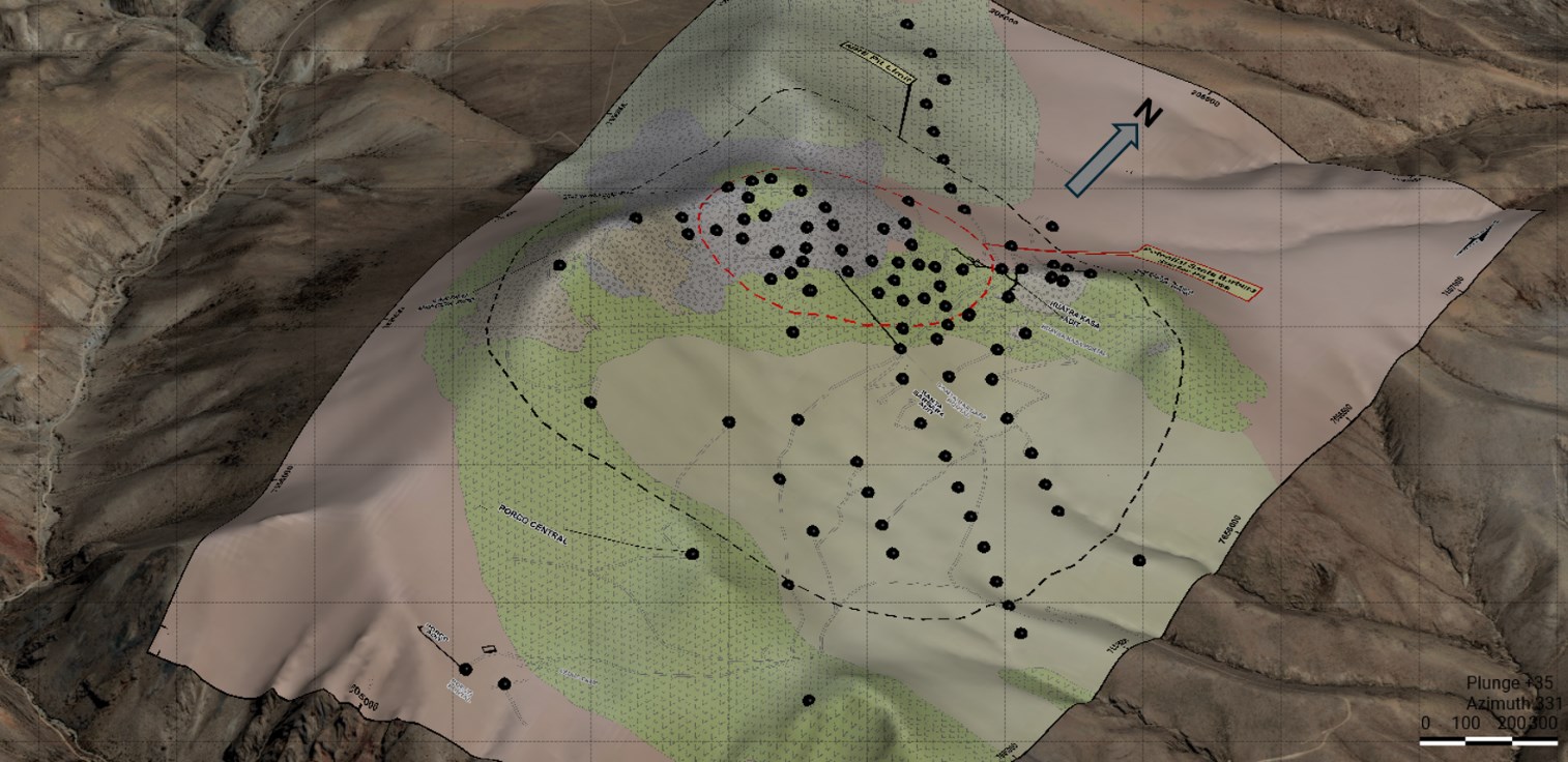
Source: Micon 2026 – Generated from the MRE Database.
Modelling
Modelling of the deposit is based on the polymetallic index technique. A polymetallic index is a single number used to describe how strongly a location is mineralized when more than one metal is important. In an Ag-Zn-Pb-Sn system, different parts of the deposit can be dominated by different metals, so no single element can define mineralization everywhere. To build the index, each metal is first put on the same scale so they can be compared fairly, and then, at each sample or block, the metal with the strongest anomaly is selected. The resulting index simply reflects the strongest metal signal present at that location, regardless of which metal it is. This allows a single, geology-based mineralization envelope to be defined that includes Sn-rich, Pb-Zn-rich, or Ag-rich zones without introducing economic assumptions such as prices or recoveries. Power 2 metallic index was used to define the overall envelope of the deposit (LDD) while power 4 metallic index was used to define the high density drilled (HDD) area. Incidentally, the Indicated mineral resource is located within the HDD. The resultant wireframes/solids are shown in Figure 2.

Figure 2: Iska Iska Deposit Wireframes in 3D Perspective
To view an enhanced version of this graphic, please visit:
https://images.newsfilecorp.com/files/1539/293755_0fe08a9484b95a25_029full.jpg
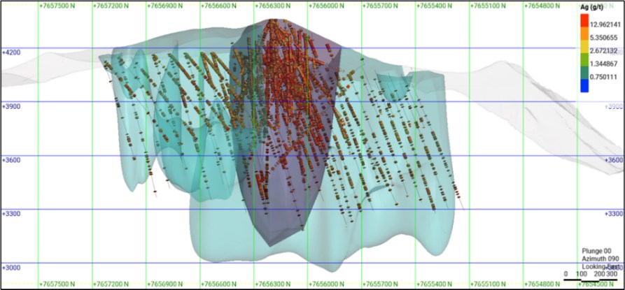
Source: Micon 2026 (Note: light blue = LDD; purple = HDD).
Grade Interpolation
Following statistical/geostatistical interpretation and grade capping, grade interpolation was conducted utilizing the ID3 technique. Ordinary kriging (OK) and nearest neighbour (NN) techniques were used to validate the block grades in addition to comparing block grades to drillhole intercepts. The ID3 technique was preferred for reporting the block grades as it highlights higher grade zones with better precision than the OK method.
Pit Optimization
To assess reasonable prospects for eventual economic extraction, open pit optimization was carried out using the Lerch Grossman method utilising the parameters/factors listed in notes numbered 6, 7, and 8 above and a conservative slope angle of 48 degrees. To be conservative, Au and Sn were not included in the optimization equation. The optimization indicates a cut-off grade of 11.14 g/t silver equivalent (AgEq) with an overall strip ration of 1:1. To highlight the distribution of the metals for metallurgical optimization, the resource was partitioned into various domains utilizing the following cut-off-grades obtained from inflexion points of cumulative frequency curves/graphs: AgEq 51 g/t for the high grade Polymetallic Domain, Ag 20 g/t for the Ag Dominant Domain, 0.90% Zn for the Zn Dominant Domain, 0.12% Sn cut-off for the Sn dominant domain, AgEq 36 g/t for the medium grade Polymetallic Domain, and AgEq 11.14 g/t for the lower grade Polymetallic Domain. The tabulations are shown in Tables 1 and 2 above. The distribution of the domains is shown in Figure 3.

Figure 3: Distribution of Metal Domains in the Optimized Pit.
To view an enhanced version of this graphic, please visit:
https://images.newsfilecorp.com/files/1539/293755_0fe08a9484b95a25_030full.jpg
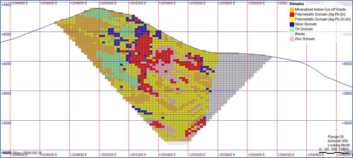
Source: Micon 2026
Classification
The mineral resource was classified into the Indicated and Inferred categories; at present there is no Measured resource. The Indicated resource is based on high density drilling (< 50 m spacing)/confidence in the sample representativity and geological continuity. The Inferred resource is in areas with sparse drilling (100 to 250 m spacing)/low sample coverage but geological continuity not in doubt; hence, it is reasonably expected that the inferred resource could be upgraded into the Indicated category with further exploration/infill drilling. Figure 4 shows the MRE classification. The Indicated resources include the ‘must take’ minor Inferred which is interlocked with masses of Indicated blocks.

Figure 4: East-west cross-section of the optimized pit showing mineral resource classification
To view an enhanced version of this graphic, please visit:
https://images.newsfilecorp.com/files/1539/293755_0fe08a9484b95a25_031full.jpg
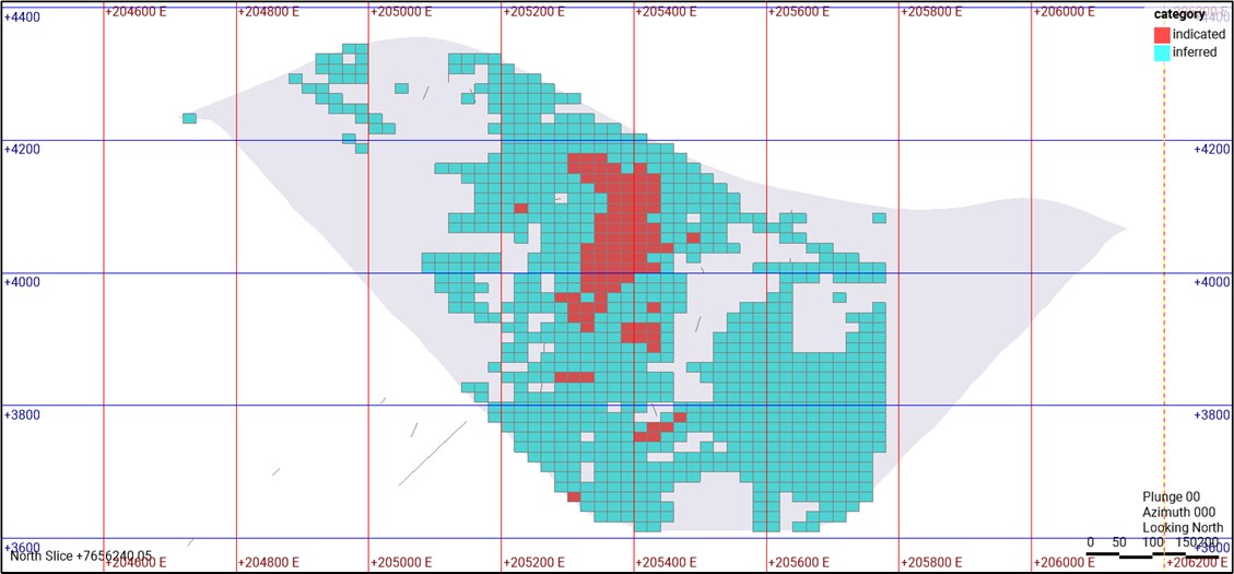
Source: Micon 2026 Resource Block Model
The Micon QPs with responsibility for the updated Mineral Resource Estimate are Charley Murahwi, P.Geo., FAusIMM and Richard Gowans P.Eng. The underground Inferred resource defined in 2023 is engulfed in the 2026 enlarged pit. The effective date of the Updated MRE is April 2, 2026.
————————————————–
Tom Larsen, CEO of Eloro, commented: “We are thrilled to announce an Updated Mineral Resource Estimate, with increases in contained tonnages, as well as grades. The continuity of higher-grade values, particularly in the Santa Barbara Zone, positions Eloro uniquely for the advancement and development of the Project, which will be detailed in the planned PEA. This Mineral Resource Estimate demonstrates the team’s ability to successfully delineate and expand the Iska Iska Project into a major Ag-Sn-polymetallic asset.”
Mr. Larsen continued: “This Updated MRE represents a defining milestone for Eloro, since it upgrades notably all of the numbers from the initial MRE in 2023, now outlining 85.17 Mt of Indicated resource and 945.43 Mt of Inferred resource, confirming the scale of the discovery at Iska Iska. Additionally, recent metallurgical work improved tin recoveries to 59%, materially enhancing the project’s potential economics. The majority of the resource is currently outlined within an optimized open pit measuring approximately 1.4km in diameter and 750m in depth, underscoring the remarkable scale of the Iska Iska mineralized system. The confirmed overall stripping ratio of 1:1 is also particularly attractive. While a substantial portion of the resource remains in the Inferred category, ongoing infill drilling is anticipated to support the conversion of these resources to the Indicated category. In addition, existing Indicated resources have the potential to be further upgraded to the Measured category with continued infill drilling. In parallel, an extensive metallurgical testing program is underway, with the potential to further improve recoveries.”
Mr. Larsen added: “These resources cover only a portion of the broader Iska Iska Project area. Based on historical drill results and geophysical data, we believe the deposit continues further along strike, across strike and at depth, providing additional targets for resource expansion possibilities beyond the solid foundation for the maiden PEA. We will be commencing shortly with the 2026, 40,000 metre drilling program, which will in part support and inform the PEA.”
Dr. Osvaldo Arce, P.Geo., Eloro’s Executive Vice President, Exploration and Latin America Operations commented: “The 2026 Mineral Resource Estimate clearly demonstrates that the Iska Iska is a major asset with extensive Ag-Sn-polymetallic mineralization. Our initial 50m-by-50m definition drilling has been very effective in confirming continuity of higher-grade mineralization, especially silver and tin, while also transforming previously reported waste areas into resources, significantly increasing overall tonnage and grades. Furthermore, the large remaining lower-grade inferred polymetallic mineral resource is due to the fact that it has been minimally drilled or yet to be drilled (Polymetallic Domains 1 and 2 in Table 2). This confirms that we improved our geological understanding of the mineralization and its host structures and this facilitates the delineation of the different metal domains, which significantly influences the quality of the estimate. Additionally, Iska Iska also hosts important potential resources of indium, rare earth elements contained principally in monazite and disseminated low-grade gold. The Company will be continuing with its responsible mineral exploration program, environmental protection and respect for the rights of local communities to ensure sustainable and equitable growth. We will keep advancing Iska Iska as one of the largest Ag-Sn-polymetallic resources in Bolivia and Latin America.”
Qualified Person
Dr. Osvaldo Arce, P.Geo. Executive Vice President, Latin America for Eloro and General Manager of Eloro’s Bolivian subsidiary, Minera Tupiza S.R.L, and a Qualified Person (“QP”) as defined by National Instrument (“NI”) 43-101 has reviewed and approved the technical content of this news release. Dr. Arce who has more than 35 years of mineral exploration and extensive mining expertise across several countries in North and South America manages the overall technical program and supervises all field work conducted at Iska Iska.
Eloro utilized both ALS and AHK for drill core analyses, both of whom are major international accredited laboratories. Drill samples sent to ALS were prepared in both ALS Bolivia Ltda’s preparation facility in Oruro, Bolivia and the preparation facility operated by AHK in Tupiza with pulps sent to the main ALS Global laboratory in Lima for analysis. Drill core samples sent to AHK Laboratories are also prepared by AHK in Tupiza with pulps sent to the AHK laboratory in Lima, Peru.
Silver (Ag), zinc (Zn) and lead (Pb) are analyzed by Inductively Coupled Plasma Atomic Emission Spectroscopy (ICP-AES) using a four-acid digestion; Sn is analyzed by X-Ray Fluorescence (XRF) and Au is analyzed by fire assay on 50g pulps with an Atomic Absorption Spectroscopy (AAS) finish. AAS measures absorbed light to quantify elements, while ICP, such as ICP-OES or ICP-MS, measure emitted light or ions to determine elements. XRF uses fluorescent X-rays to excite atoms and to emit X-rays that reveal the presence and concentration of tin. Sample size in ICP typically ranges from 100 mg (0.1 g) to 1 g, for AAS, is usually less than 100 mg (0.1 g) and for XRF is ideally below 75 µm.
Check samples between ALS and AHK are regularly done as a QA/QC check. AHK is following the same analytical protocols used as with ALS and with the same QA/QC protocols except for Sn for which a sodium peroxide fusion is used at AHK following by ICP. Check comparisons of Sn results from ALS and ALS indicate no statistically significant difference between results using the two different analytical techniques.
Eloro employs an industry standard QA/QC program with standards, blanks and duplicates inserted into each batch of samples analyzed at both laboratories with selected check samples sent to a separate accredited laboratory. Check results are regularly monitored.
About Iska Iska
The Iska Iska silver-tin polymetallic project is a road accessible, royalty-free property, wholly controlled by Eloro Resources Ltd. and is located 48 km north of Tupiza city, in the Sud Chichas Province of the Department of Potosi in southern Bolivia. Eloro has an option to earn a 100% interest in Iska Iska.
Iska Iska is a major silver-tin polymetallic porphyry-epithermal complex associated with a Miocene collapsed/resurgent caldera, emplaced on Ordovician age rocks with major breccia pipes, dacitic domes and hydrothermal breccias. The caldera is 1.6 km by 1.8 km in dimension with a vertical extent of at least 1km. Mineralization age is similar to Cerro Rico de Potosí and other major deposits such as San Vicente, Chorolque, Tasna and Tatasi, all located along the same overall geological trend.
Eloro began underground diamond drilling from the Huayra Kasa underground workings at Iska Iska on September 13, 2020. On January 26, 2021, Eloro announced significant results from the first drilling at the Santa Barbara Breccia Pipe (SBBP) including the discovery hole DHK-15 which returned 29.53g Ag/t, 0.078g Au/t, 1.45%Zn, 0.59%Pb, 0.080%Cu and 0.056%Sn over 257.5m, from surface. Subsequent drilling has confirmed the presence of significant values of Ag-Sn polymetallic mineralization in the SBBP and the adjacent Central Breccia Pipe (CBP). A substantive mineralized envelope which is open along strike and down-dip extends around both major breccia pipes. Continuous channel sampling along the walls of the Santa Barbara Adit located to the east of SBBP returned average grades of 164.96 g Ag/t, 0.46%Sn, 3.46% Pb and 0.14% Cu over 166m including 446 g Ag/t, 9.03% Pb and 1.16% Sn over 56.19m. The west end of the adit intersects the end of the SBBP.
Since the initial discovery hole Eloro has released a number of significant drill results in the SBBP and the surrounding mineralized envelope which, along with geophysical data, has defined an extensive target zone. On October 17, 2023, Eloro filed the NI 43-101 Technical Report outlining the initial inferred MRE for Iska Iska, prepared by independent consultants Micon International Limited. The MRE was reported in two domains, the Polymetallic (Ag-Zn-Pb) Domain which is primarily in the east and south of the Santa Barbara deposit and the Tin (Sn-Ag-Pb) Domain which is primarily in the west and north.
Metallurgical tests reported on January 23, 2024, from a 6.3 tonne PQ drill core bulk sample representative of the higher grade Polymetallic (Ag-Zn-Pb) Domain returned a significantly higher average silver value of 91 g Ag/t compared to the weighted average grade of the original twinned holes at 31 g Ag/t strongly suggesting that the average silver grade was likely significantly underreported in the original twinned holes due to the much smaller sample size.
The Company reported on July 30, 2024, that updated modelling of the potential starter pit area at Santa Barbara zone highlights the importance of completing additional drilling to better define the grade and extent of the mineral resource in this area. Areas with higher-grade resource typically have much better drilling density but holes outside the core potential pit area are too widely spaced to give an accurate estimate of grade.
On September 4, 2024, the Company announced the restart of definition drilling in the potential starter pit area at Santa Barbara. It was highly focused on infill and step-out drill program in order to better define the full vertical and lateral extent of high-grade Sn and Ag mineralization, expanding higher-grade Sn mineralization to the west and the silver to the central and west parts. Also, to fill-in gaps that were formerly categorized as low-grade or internal waste in the mineral resource model and to drill in a closer-spacing 50m x 50m grid. Previous drilling has shown that areas with high-grade mineralization typically have much better drilling density, whereas holes outside the core area are too widely spaced to give an accurate grade estimate. This increased drilling density is particularly important for defining the extent of the high-grade Ag-bearing and Sn-bearing structures, and for categorizing the mineral resources from inferred to indicated, which have a major influence on overall grade and resources that will contribute to the PEA.
Since September 4, 2024, the Company has completed 27 drill holes totalling 14,085.80 metres of definition drilling in 2 distinct phases of diamond drilling in the potential starter pit area of the Santa Barbara Zone. This drilling has continued to intersect strong, broad zones and high-grade mineralization with good continuity in both the predominant Sn-Ag domain to the west (15 drill holes) and in the predominant Ag-Zn-Polymetallic domain to the east (12 drill holes). Both zones remain open along and across strike as well as downdip.
The intercepts of 151.47 g Ag/t over 135m found in hole DSB-75; 66.90g Ag/t over 289.13m in hole DSB-68; 126.10g Ag/t over 122.03m, 127.49g Ag/t over 41.25m and 49.71g Ag/t over 142.50m found in hole DSB-69; and 45.71g Ag/t over 81.00m and 30.08g Ag/t over 255.75m found in hole DSB-70 confirm the presence of continued silver pockets grading over 50 g Ag/t. Moreover, tin enriched pockets such as 1.39% Sn over 33m, 0.74% Sn over 87m found in hole DSB-72 and 0.55% Sn over 49.5m, 0.34% Sn over 91.5m, 0.31% Sn over 103.5m in hole DSB-74 demonstrate the existence of consistent high grade tin pockets at the Santa Barbara zone. And finally, the presence of intercepts such as 1.41% Zn over 151.50m in hole DSB-91, 1.77% Zn over 238.50m and 1.72% Zn over 456m found in hole DSB-88 reveal continuous Zn (and Pb) ore shoots in the property. These results have further expanded, at least 200m laterally, the higher-grade tin and silver and polymetallic (Ag-Sn-Zn-Pb) mineralization and the footprint of this large multi-phase hydrothermal system at Iska Iska.
About Eloro Resources Ltd.
Eloro is an exploration and mine development company with a portfolio of precious and base-metal properties in Bolivia, Peru and Quebec. Eloro, through its Bolivian subsidiary, Minera Tupiza SRL, has a 99% joint venture interest and a 100% economic participation interest in the highly prospective Iska Iska Property, which can be classified as a polymetallic epithermal-porphyry complex, a significant mineral deposit type in the Potosi Department, in southern Bolivia. A NI 43-101 Technical Report on Iska Iska, which was completed by Micon International Limited, is available on Eloro’s website and under its filings on SEDAR+. Iska Iska is a road-accessible, royalty-free property. Eloro also owns an 82% interest in the La Victoria Gold/Silver Project, located in the North-Central Mineral Belt of Peru some 50 km south of the Lagunas Norte Gold Mine and the La Arena Gold Mine.
For further information please contact either Thomas G. Larsen, Chairman and CEO or Jorge Estepa, Vice-President at (416) 868-9168
Information in this news release may contain forward-looking information. Statements containing forward-looking information express, as at the date of this news release, the Company’s plans, estimates, forecasts, projections, expectations, or beliefs as to future events or results and are believed to be reasonable based on information currently available to the Company. There can be no assurance that forward-looking statements will prove to be accurate. Actual results and future events could differ materially from those anticipated in such statements. Readers should not place undue reliance on forward-looking information.
Cartier Resources on the Move
Towards the middle of March, Philippe Cloutier, CEO of Cartier Resources (ECR.V) got on the first of at least a dozen planes flying around the world to market the Cartier story: London, Paris, Frankfurt, Munich, Hong Kong and Singapore. Cloutier was spreading the word to investors worldwide.
Exploration and development stories take a while to ripen. It is one thing to have targets stretching over 15 kilometres of prime gold ground along the Abitibi belt. But for serious investors to be interested, those targets have to be drilled and the results posted. Which is exactly what Cartier has been doing.
Since September 2025, Cartier has put out ten results-driven news releases, one every two weeks or so. Each reports two or three fairly short holes, all report good to excellent gold values. Most of the holes have encountered relatively shallow gold mineralization.
In the process, Cartier is racking up gold ounces in “inventory” and gaining a profound understanding of the geological structures which host the gold. In its most recent news release, Cartier disclosed the discovery of “a new style of gold mineralization (intrusion-related gold deposits) within the underexplored Pontiac sedimentary Group in Hope Sector”. A style of mineralization which is similar to “large-scale gold mineralization typical of porphyry intrusion-related systems in the Pontiac sediments that are reminiscent of the Canadian Malartic Camp”.
Early days and all, “Sure, we’re drilling in places we had not planned to drill,” said Cloutier in a phone call. “It’s a long shot, but it could be another Canadian Malartic”.
Canadian Malartic was initially developed by Osisko Mining as a huge open pit operation producing hundreds of thousands of ounces of gold per year. It was sold to a partnership between Yamana Gold and Agnico Eagle in 2014, and Agnico bought out Yamana in 2023. It is 25 km West of Val-d’Or and is Canada’s largest gold mine. Here’s a picture for scale:

A gold camp on the scale of Canadian Malartic would transform Cartier, and that is exactly what Cloutier is looking for.
And it is not as long a shot as you might imagine. Malartic was, prior to Osisko’s massive development, an area which hosted several underground gold mines. Mines which were similar to the Chimo mine on the Cadillac Project, which was where Cloutier started drilling up his resource. The Chimo mine went down nearly 1000 meters with 19 levels of workings. It was very typical of the mines on the Abitibi belt.
So, when Cloutier was meeting with one of the two hundred people and groups he spoke to on his round-the-world trip, he had results to discuss and a much larger concept to bring into play. Being able to mention Canadian Malartic in the context of the Cadillac project will perk up the ears of gold mining investors. When Osisko began consolidating the Malartic project in 2004, it was trading as a junior explorer at less than a $1.00, when Canadian Malartic was bought out in 2014, the shares were worth about $8.00.
The Hope Sector is one, somewhat unexpected, part of the overall Cadillac project. You can get a sense of the scope of the potential gold camp from this map:

Cloutier had never taken the Cartier story to Asia. This time he did. He worked with a Hong Kong investment bank, which arranged meetings with institutional investors and family offices. Cloutier was well received wherever he went.
“Clearly, in Asia, there is a real understanding of gold as a store of value,” said Cloutier. “There was no real resistance, but there was uncertainty because of the events in Iran.”
“It was interesting. Great questions,” said Cloutier. “And all the meetings went over their allotted time.”
“One question which came up was “How is the dynamic with Agnico Eagle?” It’s a question I like because Agnico owns 27% of Cartier, and people expect them to buy us out. But our relationship with Agnico is great. Agnico has grown very rapidly, and as long as we stick with our plan, there is no reason for them to buy us out.”
“Another gentleman told me, “We reviewed Cartier six years ago,” I replied that the company had evolved since then. “I know. Why do you think I am here?”
“In fact, we’re setting the stage for a transformative year,” said Cloutier. “Something needs to happen this year. We’re at an inflection point.”
It’s not obvious what that something is. But the recent appointment of Glenn Mullan to Cartier’s Board is suggestive. As Chairman of the Board, Daniel Massé puts it, “As Cartier continues to advance on its strategic path, the appointment of Glenn Mullan represents a meaningful addition to our Board. Glenn brings a highly complementary combination of geological, corporate and capital markets expertise, together with a strong track record of value creation in the mining sector. His insight and experience will be particularly valuable as the Company moves forward with increasing focus, added depth and a clear vision for the future.”
Mullan has led two resource companies to acquisition by larger companies. He is experienced on the royalty side of the game as well.
Transformation can come in many guises. The only thing certain is that Philippe Cloutier will do all he can to ensure that his shareholders benefit from any transformative event.